| Reference: | S39539 |
| Author | Guillaulme DE L'ISLE |
| Year: | 1720 |
| Zone: | China, East Indies |
| Printed: | Amsterdam |
| Measures: | 635 x 635 mm |
| Reference: | S39539 |
| Author | Guillaulme DE L'ISLE |
| Year: | 1720 |
| Zone: | China, East Indies |
| Printed: | Amsterdam |
| Measures: | 635 x 635 mm |
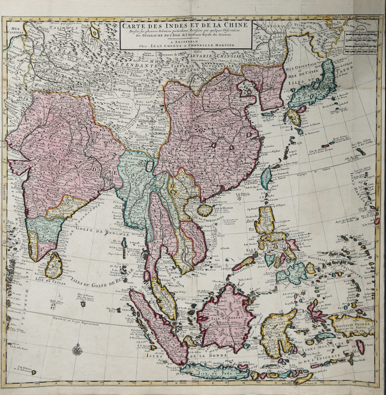
The map is based upon the earlier work of the famed geographer Guillaume De L'Isle. It covers much of Asia, from China and Japan, south to New Guinea and the Moluccas, west through Malaysia and Indonesia to what is today Vietnam and Thailand, and India.
Dotted lines mark political boundaries. The map is thickly detailed with settlements, geographic features, and ethnographic notes. There is a simple title cartouche in the top center, with a quadruple scale bar in the upper right corner.
While most of the outlines of the continent appear familiar to the modern eye, the landmass north of Japan may prove surprising. Here, the “Terre de Yeco ou d’Eso.” Yeco is a reference to Jesso, a feature included on many seventeenth and eighteenth-century maps. Historically, Eso (Jesso, Yedso, Yesso) refers to the island of Hokkaido. It varies on maps from a small island to a near-continent sized mass that stretched from Asia to Alaska.
The thoroughness of the information included here, and its density, is characteristic of Guillaume De L’Isle, who originally drafted the map. Covens and Mortier, a powerful publishing partnership based in Amsterdam, published French maps for the Dutch market.
Guillaulme DE L'ISLE (1675 - 1726)
|
vershadowed by his more famous son, Guillaume.
Guillaume De L’Isle, (1675-1726) Premier Geographe to the French king, was probably the leading map-maker of the period. His work was important as marking a transition from the maps of the Dutch school, which were highly decorative and artistically-orientated, to a more scientific approach, which reduced the importance given to the decorative elements, and emphasized the scientific base on which their maps were constructed, out of which the modern school of cartography emerged. He was prominent in the recalculation of latitude and longitude, based on the most up-to-date celestial observations, and his major contribution was in collating and incorporating this information in his maps, setting a new standard of accuracy, quickly followed by many of his contemporaries, including the Dutch firm of Covens and Mortier.
Having learnt geography from his father, it is said that at the age of eight or nine he could draw maps to demonstrate ancient history. He studied mathematics and astronomy under J.D. Cassini, where he received the grounding in scientific cartography, that is the hallmark of his work.
His first atlas was published in about 1700, in 1702 he was elected a member of the Academie Royale des Sciences, and in 1718 became Premier Geographe du Roi. His maps of the newly explored parts of the world reflect the most up-to-date information available and did not contain fanciful detail in the absence of solid information.
After his death in 1726 his business was continued by his nephew Philippe Buache, and subsequently by J. Dezauche.
Joseph Nicholas De L’Isle (1688-1768), Guillaume’s brother, became a friend of Peter the Great and supplied him with information on the Russian Empire. He stayed in Russia for twenty-two years and was in charge of the Royal Observatory in St. Petersburg, returning to France in 1747, taking with him much of the material he had access to, particularly relating to explorations along the northern Pacific coasts of Russia and America, which he subsequently published. The Atlas Russicus was published in 1747 and contained twenty maps.
Simon Claude De L’Isle (1675-1726) was a historian. It is curious to note that he was born and died in the same years as his elder brother Guillaume.
|