| Reference: | s29418 |
| Author | Tobias Conrad LOTTER |
| Year: | 1750 ca. |
| Zone: | Central Italy |
| Printed: | Augsburg |
| Measures: | 585 x 510 mm |
| Reference: | s29418 |
| Author | Tobias Conrad LOTTER |
| Year: | 1750 ca. |
| Zone: | Central Italy |
| Printed: | Augsburg |
| Measures: | 585 x 510 mm |
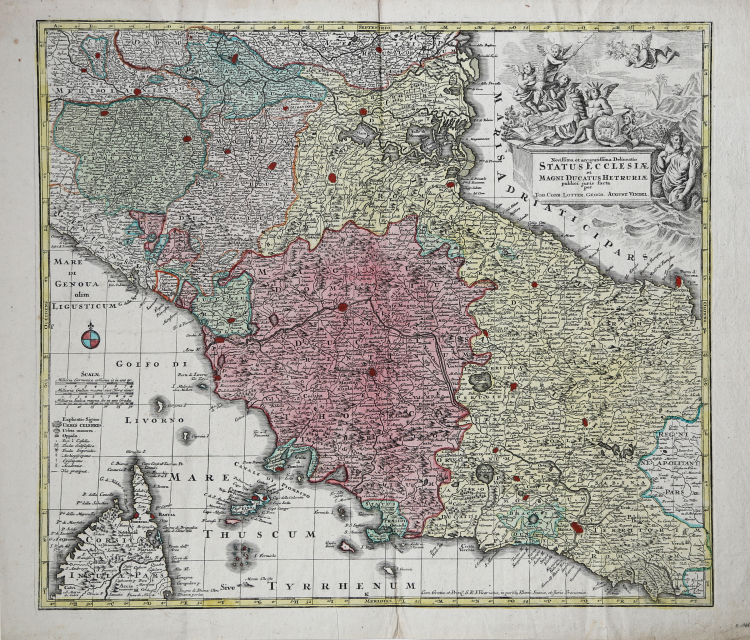
Second state of the map of Central Italy by Seutter, with the imprint of Tobias Conrad Lotter.
“Per la graduazione, orientazione e scale vedi la carta precedente, di cui questa rappresenta la stessa area, centrata sul Granducato di Toscana e sullo Stato Pontificio. Tratta dal Grosser Atlas (e non dal Novus Atlas), cambia ad ogni modo la figurazione del cartiglio, dove compaiono simboli ecclesiastici, lo stemma mediceo e un diverso sfondo paesaggistico. Sono però evidenti le affinità, sia per quanto attiene ai dati tecnici e scientifici che agli elementi formali e stilistici: è quanto osserva anche F. R. Cassano (p. 108) che la riporta nella sua raccolta, segnalandola però come anonima e con T. C. Lotter quale cartografo (questi, genero di Seutter, dalla cui officina in mezzo secolo usciranno circa 400 carte, ne continuò l'opera pubblicando vari atlanti, ma senza introdurvi novità)” (cfr. "Le antiche terre del Ducato di Spoleto", p. 162).
Matthäus Seutter (1678 - 1757) was one of the most important and prolific German map publishers of the 18th century. Seutter was born the son of a goldsmith but apprenticed as a brewer. Apparently uninspired by the beer business, Seutter abandoned his apprenticeship and moved to Nuremberg where he apprenticed as an engraver under the tutelage of the prominent J. B. Homann. Sometime in the early 1700s Seutter left Homann to return to Augsburg, where he worked for the prominent art publisher jeremiad Wolff (1663 - 1724), for whom he engraved maps and other prints. Most of Seutter's maps are heavily based upon, if not copies of, earlier work done by the Homann and De L'Isle firms. Nonetheless, by 1731/32 Seutter was one of the most prolific publishers of his time and was honored by the German Emperor Karl VI who gave him the title of Imperial Geographer, after which most subsequent maps included the Avec Privilege designation.
Copperplate with fine original colouring, good condition.
|
F. Ronca e A. Sorbini (a cura di) "Le antiche terre del Ducato di Spoleto", p. 162, 67.
|
Tobias Conrad LOTTER (1717 - 1777)
|
Tobias Conrad Lotter (1717 - 1777) was a German engraver and map publisher. Lotter was the son of a baker and city guardsman, but married Euphrosina Seutter (1709-1784), elder daughter of the prominent map publisher Matthäus Seutter. He began working at his is father-in-law's map business about 1740. Between 1740 and 1744 he produced, under Seutter's imprint, the Atlas minor, Praecipua orbis terrarum imperia, regna et provincias, Germania potissimum tabelli. Upon Seutter's death, in 1757, the firm's stock was taken over by his son, Albrecht Karl Seutter (1722-1762), who himself died in 1762, just a few years later. The remaining Suetter map plates were subsequently divided between Lotter and the publisher Johan Mitchell Probst (1727 - 1776). With the support of his sons, Matthäus Albrecht (1741-1810), Georg Friedrich (1744-1801) and Gustav Conrad (1746-1776), Tobias Conrad Lotter succeeded in building on the economic success and professional reputation of his father-in-law. In time, Lotter became one of the most prominent mid-18th century map publishers working in the German school. After Lotter's death in 1777, the business was taken over by his two eldest sons, who, lacking their father's business acumen, presided over the firm's slow decline. It was nonetheless passed on to a subsequent generation of Lotters, Matthäus Albrecht Lotter's sons, Gabriel (1776-1857) and Georg Friedrich (1787-1864), who pushed it into further decline until it faded out in the early-19th century.
c.1744 Atlas Minor
1760 -62 Atlas Geographicus portabilis
c.1770 Atlas Novus
1776 A map of the most inhabited part of New England
1778 Atlas Geographique
1778 (M.A. Lotter) World Map showing Cook’s voyages
|
|
F. Ronca e A. Sorbini (a cura di) "Le antiche terre del Ducato di Spoleto", p. 162, 67.
|
Tobias Conrad LOTTER (1717 - 1777)
|
Tobias Conrad Lotter (1717 - 1777) was a German engraver and map publisher. Lotter was the son of a baker and city guardsman, but married Euphrosina Seutter (1709-1784), elder daughter of the prominent map publisher Matthäus Seutter. He began working at his is father-in-law's map business about 1740. Between 1740 and 1744 he produced, under Seutter's imprint, the Atlas minor, Praecipua orbis terrarum imperia, regna et provincias, Germania potissimum tabelli. Upon Seutter's death, in 1757, the firm's stock was taken over by his son, Albrecht Karl Seutter (1722-1762), who himself died in 1762, just a few years later. The remaining Suetter map plates were subsequently divided between Lotter and the publisher Johan Mitchell Probst (1727 - 1776). With the support of his sons, Matthäus Albrecht (1741-1810), Georg Friedrich (1744-1801) and Gustav Conrad (1746-1776), Tobias Conrad Lotter succeeded in building on the economic success and professional reputation of his father-in-law. In time, Lotter became one of the most prominent mid-18th century map publishers working in the German school. After Lotter's death in 1777, the business was taken over by his two eldest sons, who, lacking their father's business acumen, presided over the firm's slow decline. It was nonetheless passed on to a subsequent generation of Lotters, Matthäus Albrecht Lotter's sons, Gabriel (1776-1857) and Georg Friedrich (1787-1864), who pushed it into further decline until it faded out in the early-19th century.
c.1744 Atlas Minor
1760 -62 Atlas Geographicus portabilis
c.1770 Atlas Novus
1776 A map of the most inhabited part of New England
1778 Atlas Geographique
1778 (M.A. Lotter) World Map showing Cook’s voyages
|