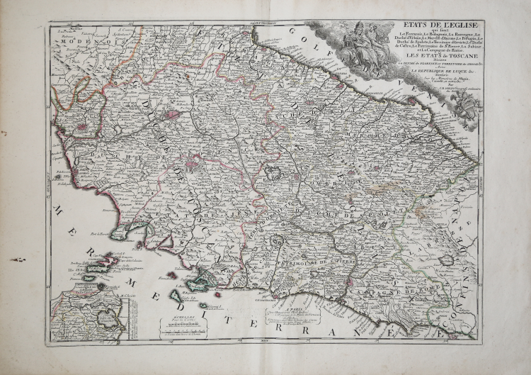
| Reference: | CO-269 |
| Author | Jean Baptiste NOLIN |
| Year: | 1702 ca. |
| Zone: | Central Italy |
| Printed: | Paris |
| Measures: | 640 x 480 mm |
| Reference: | CO-269 |
| Author | Jean Baptiste NOLIN |
| Year: | 1702 ca. |
| Zone: | Central Italy |
| Printed: | Paris |
| Measures: | 640 x 480 mm |
I modelli cartografici di riferimento per la realizzazione di quest'opera, sono Magini e Cantelli, come lo stesso autore dichiara nel titolo, rispetto ai quali, però, presenta elementi innovativi, in primis l'accurato rilevamento dei confini politico-amministrativi.
L'elaborato cartiglio mostra lo stemma di papa Clemente XI Albani. La carta viene realizzata per Le Theatre de la Guerre en Italie, per la prima volta edito nel 1701. L’opera descrive dettagliatamente la Campagna d’Italia del 1701-1702 che vede coinvolti territori dell’Italia settentrionale con Milano, Cremona, Mantova, Parma, Modena, Bergamo, Crema, Brescia, Verona, Vicenza, Padova, Ferrara e Bologna.
La tipografia Nolin venne fondata da Jean Baptiste Nolin (1657-1708 circa) che intraprende l’attività editoriale di famiglia a Parigi, in Rue St. Jacques, dove il padre aveva una bottega d’incisione. Allievo di Francois de Poilly, verso la fine del secolo iniziò a godere di una certa notorietà fino a diventare “graveur ordinaire du roi, marchand de tailles douces” e, nel 1694, “géographe du duc d’Orléans”, fratello di re Louis XIV. Alla scomparsa del duca, nel 1701, assunse la qualifica di “geographe du Roy”. La sua carriera ebbe una certa evoluzione dopo l’incontro con l’abate Vincenzo Maria Coronelli che gli affidò l’incisione del suo grande globo celeste di 28 fusi.
Nolin, non essendo un geografo vero e proprio, aveva difficoltà a realizzare carte originali e, pertanto, si rifaceva a modelli di altri geografi. Molte delle sue opere si basano sulle incisioni di Coronelli - alcune realizzate in collaborazione - e di un altro cartografo francese, Jean Nicolas de Tralage detto Tillemon.
Altra fonte per le sue carte furono le informazioni che arrivavano dalle guerre in Europa, alle quali aveva accesso essendo “geographe du Roy”. Nel 1701 stesso il Nolin pubblicò Le Theatre de la Guerre en Italie, una raccolta composta da iniziali 18 carte che fu bene presto ristampata e aggiornata.
Incisione in rame, finemente colorata a mano, consuete pieghe di carta, in buono stato di conservazione.
Acquaforte, coloritura coeva dei contorni, in ottimo stato di conservazione.
Jean Baptiste NOLIN (circa 1657 - 1708)
|
Jean-Baptiste Nolin (ca. 1657-1708) was a French engraver who worked at the turn of the eighteenth century. Initially trained by Francois de Poilly, his artistic skills caught the eye of Vincenzo Coronelli when the latter was working in France. Coronelli encouraged the young Nolin to engrave his own maps, which he began to do.
Whereas Nolin was a skilled engraver, he was not an original geographer. He also had a flair for business, adopting monikers like the Geographer to the Duke of Orelans and Engerver to King XIV. He, like many of his contemporaries, borrowed liberally from existing maps. In Nolin’s case, he depended especially on the works of Coronelli and Jean-Nicholas de Tralage, the Sieur de Tillemon. This practice eventually caught Nolin in one of the largest geography scandals of the eighteenth century.
In 1700, Nolin published a large world map which was seen by Claude Delisle, father of the premier mapmaker of his age, Guillaume Delisle. Claude recognized Nolin’s map as being based in part on his son’s work. Guillaume had been working on a manuscript globe for Louis Boucherat, the chancellor of France, with exclusive information about the shape of California and the mouth of the Mississippi River. This information was printed on Nolin’s map. The court ruled in the Delisles’ favor after six years. Nolin had to stop producing that map, but he continued to make others.
Calling Nolin a plagiarist is unfair, as he was engaged in a practice that practically every geographer adopted at the time. Sources were few and copyright laws weak or nonexistent. Nolin’s maps are engraved with considerable skill and are aesthetically engaging.
Nolin’s son, also Jean-Baptiste (1686-1762), continued his father’s business.
|