
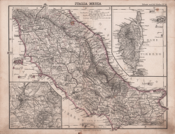
| Reference: | CO-205 |
| Author | Adolf STIELER |
| Year: | 1880 |
| Zone: | Central Italy |
| Printed: | Turin |
| Measures: | 310 x 240 mm |
| Reference: | CO-205 |
| Author | Adolf STIELER |
| Year: | 1880 |
| Zone: | Central Italy |
| Printed: | Turin |
| Measures: | 310 x 240 mm |
Carta tratta dall’Atlante scolastico per la geografia politica e fisica: scelta di 25 tavole incise in rame e miniate, eseguita sulla quarantesima edizione originale dell'atlante scolastico di Ad. Stieler ed Erm. Berghaus. . - (Torino, Firenze e Roma : libreria di Ermanno Loescher, 1880).Gotha : Giusto Perthes, 1880.
Edizione italiana dell’atlante scolastico di Adolf Stieler (Gotha, 26 febbraio 1775 – Gotha, 13 marzo 1836) è stato un cartografo tedesco. Stieler è noto per aver dato un significativo contributo allo sviluppo della cartografia in Germania, che raggiunse il suo apice con l'Atlante Stieler da lui curato. Le carte di Stieler vennero apprezzate anche da altri editori e fu così che egli iniziò la collaborazione con Justus Perthes, che sarebbe durata per tutta la sua vita. Nel 1815 Stieler propose a Perthes di pubblicare un atlante che si distinguesse per praticità del formato, maggiore precisione possibile, chiarezza e completezza, nonché adeguata scelta e regolarità della proiezione e della scala, qualità della carta e della stampa, cura della colorazione e prezzo contenuto. Il così denominato Stielers Handatlas ("Atlante Stieler"), che era formato da 50 tavole, fu dato alle stampe in fascicoli tra il 1817 e il 1823 e riscosse col tempo un notevole successo, anche oltre la morte dell'autore, avvenuta nel 1836; di fatto l'Atlante Stieler rappresentò il meglio della produzione geografica tedesca tra la seconda metà del XIX secolo e l'inizio del Novecento.
Adolf STIELER (Gotha 1775 - 1836)
|
Adolf Stieler (26 February 1775 – 13 March 1836) was a German cartographer and lawyer who worked most of his life in the Justus Perthes Geographical Institute in Gotha. Although he studied law and would serve in government for his entire career, he maintained an interest in cartography and published many famous works. His Handatlas was the leading German world atlas until the middle of the 20th century.
Stieler's cartographic career began with a position as a geography teacher at a girls' school in Gotha. However, he began work with Franz Xaver von Zach, the director of the Gotha Observatory. His works during this period include publishing cartographic representations of a number of von Zach's observations. Such illustrations were completed in von Zach's "Allgemeinen Geographischen Ephemeriden" or "General Geographical Ephemeris," published in 1798.
Map of Southeast Asia, printed in Stielers Handatlas.
In 1804, Stieler worked in the Geographical Institute of Weimar, continuing his goal of starting a geographical publishing business.
He also produced a number of regional and international maps. With von Zach, Stieler published his "Atlas Gaspari," which included maps of many European nations, including Spain, Portugal, and England.[3] In 1806, his map of the East Indies was published. Later he would publish a 25 sheet military map of Germany that was part of a larger 204 sheet work. His maps were well known for their inclusion of new information from exploration and culture. He also incorporated a "System der fortwährenden Modernisierung," or "System of Ongoing Modernization," in his map creation and issuing.
However, he began work on his most famous and long-lasting work, the Handatlas, in 1816 after a long hiatus from cartographic work. By 1826, when he completed the Handatlas, his career was nearing its end. His 1836 map of Germany would remain unfinished.
|