
| Reference: | CO-130 |
| Author | Pieter VANDER AA |
| Year: | 1714 ca. |
| Zone: | Central Italy |
| Printed: | Leyden |
| Measures: | 205 x 155 mm |
| Reference: | CO-130 |
| Author | Pieter VANDER AA |
| Year: | 1714 ca. |
| Zone: | Central Italy |
| Printed: | Leyden |
| Measures: | 205 x 155 mm |
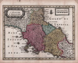
Rarissima mappa tratta dal "Nouveau Petit Atlas - Atlas soluagé de son gros pesant Fardeau" stampato a Leida, nel circa 1714.
L’atlante è incredibilmente raro e solo una copia completa è conosciuta nella biblioteca di Leida, mentre Burden possiede solo il primo volume. è composto di nove parti: una parte generale denominata “Nouveau Petit Atlas” e 8 parti con mappe regionali intitolate “Atlas Soulage de son gros e pesant Fardeau”.
Quasi tutte le mappe vengono stampate utilizzando e rielaborando le lastre di Janssonius per il suo “Atlas Minor”, atlante di ispirazione mercatoriana che prima Jodocus Hondius jr.e Pieter Kaerius, poi Johannes Janssonius ampliarono e aggiornarono. I titoli e la scala sono stati tradotti in francese. I cartigli sono stati modernizzati, con una forma tonda od ovale composta e delle rose dei venti aggiunte. Alcuni toponimi sono aggiunti, come si nota dalla diversa grafia incisa.
Questa carta dello Stato della Chiesa con la Toscana è una rielaborazione della mappa incisa da Kaerius nel 1607 circa
https://www.antiquarius.it/it/italia-centrale/15095-dominium-ecclesiasticum-in-italia.html
I cartigli vengono abrasi e sostituiti; la firma dell’incisore, in basso al centro, sebbene abrasa è ancora leggibile.
Le carte dell’Italia provengono dall’ottava ed ultima parte dell’atlante, denominata “L’Atlas Soulagé de son gros & pesant fardeu: Ou NOUVELLES CARTES GEOGRAPHIQUES qui contiennent l’ITALIE, avec le Paryies principales qui la composent comme l’Etat del L’eglise, Naples, Sicile, &c. Ouvage propre pour Vouager commodement & agréablement des Yeux”.
Acquaforte, con coloritura coeva, in ottime condizioni. Grandissima rarità cartografica.
Pieter VANDER AA (1659 - 1733)
|
Records show that van der Aa, born in Leyden in 1659, made an early start in life by being apprenticed to a bookseller at the age of nine and starting on his own in business as a book publisher by the time he was twenty-three.
During the following fifty years he published an enormous amount of material, including atlases and illustrated works in every shape and size, two of them consisting of no less than 27 and 28 volumes containing over 3,000 maps and plates.
Most of his maps were not of the first quality and were certainly not original, but they are often very decorative and are collected on that account.
|