
| Reference: | S34924 |
| Author | Henri Abraham CHATELAIN |
| Year: | 1708 ca. |
| Zone: | Saint Kitts, The Antille |
| Printed: | Amsterdam |
| Measures: | 490 x 380 mm |
| Reference: | S34924 |
| Author | Henri Abraham CHATELAIN |
| Year: | 1708 ca. |
| Zone: | Saint Kitts, The Antille |
| Printed: | Amsterdam |
| Measures: | 490 x 380 mm |
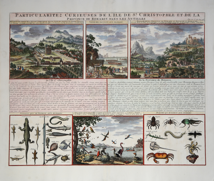
This sheet presents several views of St. Kitts and the native fauna. The view at upper left shows the Governor-General's palace - complete with elaborate formal French gardens. The view at center shows the natives welcoming the French and preparing a feast. The view at right depicts Melilot, the mythical capital of Apalache. This idealized view was taken from Charles de Rochefort's view first published in his Histoire naturelle et morale des iles Antilles de l'Amerique [1658]. The Apalache were purported to have a utopian kingdom in Georgia and Florida, and to have been the ancestors of the Carib peoples. As Melilot was not found in North America, here it has been transferred to St. Kitts. The views at bottom show a variety of native fauna. Taken from "Atlas Historique".
Henri Abraham Chatelain (1684 - 1743) was a Huguenot pastor of Parisian origins. He is best known as a Dutch cartographer and more specifically for his cartographic contribution in the seminal seven volume Atlas Historique, published in Amsterdam between 1705 and 1720. Innovative for its time, the Atlas Historique combined fine engraving and artwork with scholarly studies of geography, history, ethnology, heraldry, and cosmography. Some scholarship suggests that the Atlas Historique was not exclusively compiled by Henri Chatelain, as is commonly believed, but rather was a family enterprise involving Henri, his father Zacharie and his brother, also Zacharie.
Copper engraving, with fine later hando colour, in excellent condition.
Henri Abraham CHATELAIN (1684 - 1743)
|
Henri Abraham Chatelain (1684 - 1743) was a Huguenot pastor of Parisian origins. He is best known as a Dutch cartographer and more specifically for his cartographic contribution in the seminal seven volume Atlas Historique, published in Amsterdam between 1705 and 1720. Innovative for its time, the Atlas Historique combined fine engraving and artwork with scholarly studies of geography, history, ethnology, heraldry, and cosmography. Some scholarship suggests that the Atlas Historique was not exclusively compiled by Henri Chatelain, as is commonly believed, but rather was a family enterprise involving Henri, his father Zacharie and his brother, also Zacharie. The Atlas Historique published by Chatelain was part of a major work of its time, an encyclopaedia in seven volumes including geography as one of its main subjectes. The text was by Nicholas Gueudeville and the maps by Chatelain. The Atlas included one of the finest maps of America (4 sheets) surrounded by vignettes and decorative insets.
1705-20 Atlas Historique:Amsterdam (maps by Chatelain based on G.Delisle)
Further issues to 1739
|