
| Reference: | S10748 |
| Author | Thomas JEFFERYS |
| Year: | 1775 |
| Zone: | Canada |
| Printed: | London |
| Measures: | 955 x 610 mm |
| Reference: | S10748 |
| Author | Thomas JEFFERYS |
| Year: | 1775 |
| Zone: | Canada |
| Printed: | London |
| Measures: | 955 x 610 mm |
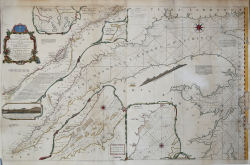
An Exact Chart of the River St. Laurence from Fort Frontenac to the Island of Anticosti shewing the Soundings, Rocks, Shoals and c with Views of the Lands and all necessary Instructions for navigating that River to Quebec.
Important 1775 chart of the St. Larence River appeared in Thomas Jefferys' The American Atlas, the publication of which was prompted by the recent conflict with the French (Seven Years' War) and the growing tensions between the British government and its colonies. The importance of the St. Lawrence River was well-understood as a strategic corridor and the main conduit for trade to and from the prosperous Canadian settlements.
The main part of the map depicts the river from Anticosti Island to Quebec. Rhumb lines appear throughout, along with soundings, hazards, anchorages, shoals, profiles of the coastline, explanatory notes, and other details of importance to a navigator aboard a ship. The chart is flanked, above and below, by several insets.
Jefferys was the leading British cartographer of the 18th century. From about 1750 he published a series of maps of the British American colonies that were among the most significant produced in the period. As Geographer to the Prince of Wales, and after 1761, Geographer to the King, Jefferys was well placed to have access to the best surveys conducted in America, and many of his maps held the status of "official work".
The best British Chart of the St. Lawrence on the Eve of the American Revolution.
Etching with fine later hand colour, usual folds, very good condition.
Bibliografia
Kershaw, Early Printed Maps of Canada II, 669.
Thomas JEFFERYS (ca.1719 – 1771)
|
"Geographer to King George III", was an English cartographer who was the leading map supplier of his day. He engraved and printed maps for government and other official bodies and produced a wide range of commercial maps and atlases, especially of North America. In 1754, Jefferys published a map of Virginia which had been surveyed by Joshua Fry and Peter Jefferson in 1751. The next year he published a Map of the Most Inhabited Part of New England surveyed by John Green, and in 1768 he published A General Topography of North America and the West Indies in association with Robert Sayer. In 1775, after his death, collections of his maps were published by Sayer as The American Atlas and The West-India Atlas.
|