
| Reference: | S27096 |
| Author | Giacomo Filippo AMETI |
| Year: | 1696 |
| Zone: | Latium |
| Printed: | Rome |
| Measures: | 1130 x 835 mm |
| Reference: | S27096 |
| Author | Giacomo Filippo AMETI |
| Year: | 1696 |
| Zone: | Latium |
| Printed: | Rome |
| Measures: | 1130 x 835 mm |
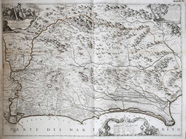
Once he had realized his project to renovate and enlarge Rome, Pope Alexander VII (Fabio Chigi) charged quite a few topographers and agronomists to realize the Roman countryiside land registry, putting the Jesuit Francesco Eschinardi in charge of the cartographic part. The best maps have been drawn by Giovan Battista Cingolati and Ameti, who realized two big size maps of the Northern and Southern neighbourhood of Rome. As Almagià points out, the two maps could be joined to form just one print, since they share a part where the river Tiber and Rome are depicted.
This work is basically after Innocenzo Mattei’s (1626-79), a Camaldolese monk, who was official geographer of Clemente X and realized his work in 1666. When compared to Mattei’s Tavola esatta dell’antico Latio e Nova Campagna di Roma, Ameti’s work shows many analogies in different fields: classical references, the names of the streets, etc. It differs from its sources on the addiction of new places, especially along the coasts.
The first map (St. Peter’s Heritage) presents a big cartouche on upper left, with the date, 1691, and the printer’s name, Domenico de Rossi, together with dedication to the Cardinal Francesco Nerli. The description of the territory is quite detailed, with wods, heights, the small towns and the lakes of Bolsena, Bracciano and Orbetello. The map of Latium, dedicated to the Cardinal Pietro Ottoboni, has been printed three years before and presents a better relief of the Pontine marshes, and even the hydrography is quite different. Ameti’s map have been included, together with Mattei’s, in the second edition of De Rossi’s Mercurio Geografico. Copperplates, realized in four plates each, joined together in the past, with the technique of etching.
Example in excellent condition, trimmed to platemark; sings of glue along the old folds.
Bibliografia
Frutaz, Le carte del Lazio, pp. 75-77; Almagià, Documenti Cartografici dello Stato Pontificio, pp. 40-42, 73; A. Bonazzi, Il Mercurio geografico: il gioco e la differenza, in “Giacomo Cantelli: geografo del Serenissimo”, Bologna, 1995, p. 37-44 e 150-152.
Giacomo Filippo AMETI (Roma, 1654 – ivi, gen. 1707)
|
A geographer and cartographer belonging to a family of Turin origin settled in Rome with Girolamo at the end of the sixteenth century, he was the author of Il Lazio con le sue più cospicue strade antiche e moderne e principali casali, e tenute di esso (Rome, Domenico De Rossi, 1693) and Patrimonio di S. Pietro, olim Tuscia suburbicaria: con le sue più cospicue strade antiche, e moderne, e principali casali, e tenute di esso (Rome, Domenico de Rossi, 1696), a map of remarkable accuracy dedicated to Cardinal Nerli. The originals are in copperplates formerly preserved at the National Calcography (now the National Institute of Graphics in Rome). They are maps that share many common features with Innocenzo Mattei's maps but with better definition of the coastal and sub-coastal layout and for more accurate orography. "These maps of Ameti and that of Cingolani, represent the best products that cartography of the Roman territory has given us in the pregeodetic period" (Almagià, La geografia, p. 7).
He died in Rome; he was buried in the church of Minerva (Jan. 20, 1707).
|