| Reference: | CO-382 |
| Author | Ferrando BERTELLI |
| Year: | 1563 |
| Zone: | Lazio |
| Printed: | Venice |
| Measures: | 465 x 320 mm |
| Reference: | CO-382 |
| Author | Ferrando BERTELLI |
| Year: | 1563 |
| Zone: | Lazio |
| Printed: | Venice |
| Measures: | 465 x 320 mm |
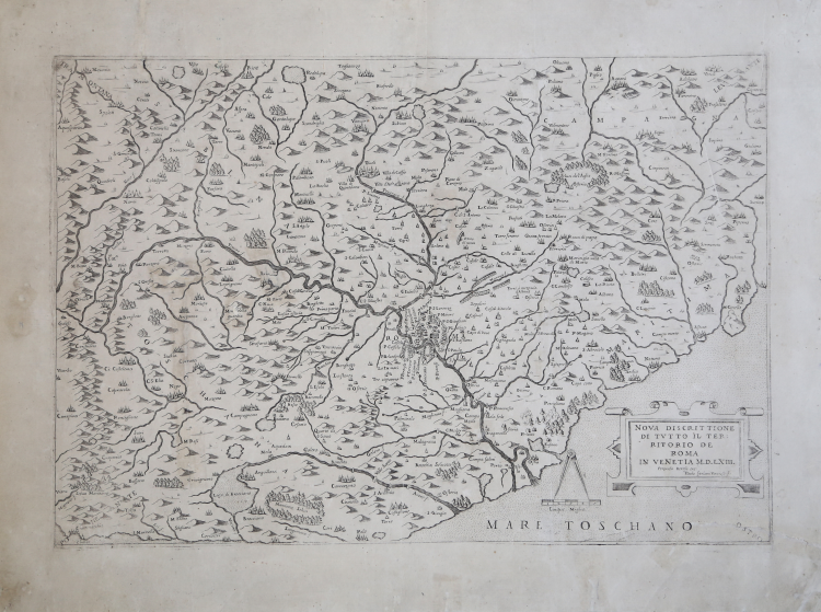
The ornate cartouche in the lower right-hand corner reads: NOVA DISCRITTIONE DI TUTTO IL TERRITORIO DE ROMA IN VENETIA M.D.L.XIII. Ferando Bertelli exc. Paulo Forlani Veronese f. Below, highlighted by a compass, we find the graphic scale of Cinque Miglia, equal to mm 38. Lower down is the MARE TOSCHANO. Orientation in the four corners with the names of the winds: TRAMONTANA, OSTRO, LEVANTE, PONENTE,, the northeast is at the top. Map lacks graduated margin.
The map of Latium engraved by Paolo Forlani for publisher Ferrando Bertelli is a derivation of Eufrosino della Volpaia's 1547 model, compared to which, however, it describes a wider territory covering almost the entirety of today's region. Almagià describes the work as a "faithful derivation of the map Territorio di Roma of 1559, with omission of the road network".
The map by Eufrosino Della Volpaia, can be considered the only original work, for the 16th century, of the Roman Campagna and was taken as a model for numerous maps of Latium. It reveals very close similarities in content with what is reported in Domenico Bocca Maza's Otto libri quali narreno de varii et diverse cose apertinenti alli Cacciatori, printed in Rome in 1548. Almagià states: “Essa può definirsi una carta topografica, e tale è anche per la copia di particolari di ogni genere e per l’esattezza del disegno delle località, le cui figurazioni prospettiche corrispondono all’aspetto reale, quale è in molti casi ancora riconoscibile, e dimostrano una perfetta conoscenza personale della Regione. Altre figurazioni di vario genere, alcune delle quali singolarissime, porgono una viva immagine della Campagna Romana in quel tempo”.
Etching and engraving, 1563, signed and dated in plate at lower right. Good proof, printed on contemporary laid paper, with margins, restored paper tear at lower right, abrasions, traces of glue on verso, overall in fair condition.
Bibliografia
Bifolco-Ronca, Cartografia e Topografia Italiana del XVI Secolo (2018), pp. 2030-31, tav. 1025; Tooley, Maps in Italian Atlases of Sixsteenth century, 480; Almagià, Monumenta Cartographica Vaticana, Carte Geografiche a Stampa, pag. 93, 23; Frutaz (1972): vol I, p. 28, tav. 42; Lago (1994): p. 279, fig. 42; Lago (2002): p. 442, fig. 441; Meurer, The Strabo Illustratus Atlas, p. 69, 55; Bella, Collezione Novacco, 72; Woodward, Forlani, 23.
Ferrando BERTELLI (attivo a Venezia seconda metà del XVI secolo)
|
Bertelli family represents the largest group of publishers, engravers, cartographers and merchants of prints of the sixteenth century. Ferrando Bertelli was the most productive, active between 1570, the 1560th, but maps of the last quarter of the century are known by the names of Andrea, Donato, Lucca, Nicholas and Peter. This was mainly active in Padua, where he led a workshop in letterpress and engravings. The earliest records show the asset at the date of 1589 as an engraver of several plates for an edition entitled Diversarum nationum habitus which was published in collaboration with Alciato Alciati. Pietro Bertelli had a library in Padua "the banner of the Angel". At his death the business was inherited by his son Francis. Bertelli was wandering engraver, copperplate engraver and publisher, print dealer active in Venice between 1561 and 1572. We do not have the precise biographical Bertelli.
He teamed with Camocio and the Forlani for the edition and trade cards and plants, they should also become the core business of spreading in the city by Italian and foreign ones, increasing the development of cartography. As a publisher chalcographer emerged from his workshop papers invention of Giacomo Gastaldi, Pirro Ligorio etc.. Although numerous papers of Drawings of the most illustrious cities and fortresses in the world (Venice 1568) bear his signature. Of 1572 is his last edition, the famous islands, harbors, fortresses … Sig.ria subject to Venice, a collection of 88 maps and charts, loose and perhaps already published some of them attributable to the engraving by Martin Rota Sibenik . Later, Ferrando mapss were reprinted by Donato Bertelli (by which we can not determine whether there were family ties) and Donato Rascicotti. Bibliography: Valerio, Cartographers Veneti, p. 149.
|