| Reference: | S46059 |
| Author | Justus Perthes |
| Year: | 1852 |
| Zone: | Moon |
| Printed: | Gotha |
| Measures: | 435 x 350 mm |
| Reference: | S46059 |
| Author | Justus Perthes |
| Year: | 1852 |
| Zone: | Moon |
| Printed: | Gotha |
| Measures: | 435 x 350 mm |
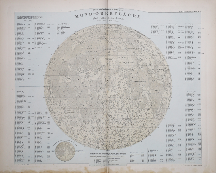
Detailed topographic map of the lunar surface, surrounded by an extensive descriptive index.
Moon map drawn by Joh. Carl Ausfeld from Beer and Mädler's model, here projected northward and thus opposite to Beer and Mädler's original projections. Scale approximately 1:13,000,000. Height and depth values of 198 topographic features are given in feet of Paris. At the bottom is a small illustration showing daily changes in lunar phase.
As mentioned, it is derived from the survey of Wilhelm Beer, (1797-1850) and Johann Heinrich Mädler, (1794-1874), [Mappa selenographica, Berlin, Apud Simon Schropp & Soc., 1834]. Beer and Mädler's map has the honor of being the first large-scale map of the Moon to be based on precise micrometer measurements. Beer was a banker and amateur observer of the Moon and owned a fine Fraunhofer refractor. Mädler, on the other hand, was an astronomer who partnered with Beer in order to measure the position of each lunar formation based on a large number of control points. The map, the result of four years of work, is divided into four sections and is nearly a meter in diameter. In 1837 it was followed by a volume of accompanying text. This map was undoubtedly the most authoritative lunar publication of the century and formed the basis for later maps by T.W. Webb and Edmund Neison.
The map is part of Adolf Stieler "s (Gotha 1775 - †1836) Hand-Atlas, published by the Justus Perthes publishing house in Gotha, which was published in ten editions from 1817 to 1944. It is considered the first modern atlas because of its geographical accuracy and graphic quality: the draft of each individual plate took a year and a half to complete.
Chromolithography, slight moisture stain at bottom, otherwise in very good condition.
Justus Perthes (Rudolstadt 1749 - Gotha 1816)
|
A member of a well-known family of German booksellers, he was born in Rudolstadt on 11 September 1749 and died in Gotha on 1 May 1816. He was the founder (1785) of the Geographical Institute Justus Perthes in Gotha, which became famous as the publisher of the Almanach de Gotha, founded in 1763 and still published since 1816. The most famous productions of the Institute are the Stielers Handatlas (1st ed. 1816; the 10th international edition is in progress), the Physikalischer Atlas by E. Berghaus (1st ed. 1836), the periodical Petermanns Mitteilungen, founded in 1855 by A. Petermann, the Geographisches Jahrbuch founded by E. Behm in 1866; also a rich series of geographical, historical, economic wall maps, chorographic maps (map of Germany by C. Vogel; 1st ed. 1891).
|