
| Reference: | S46174 |
| Author | Charles V. MONIN |
| Year: | 1839 |
| Zone: | Celestial Chart |
| Printed: | Paris |
| Measures: | 440 x 300 mm |
| Reference: | S46174 |
| Author | Charles V. MONIN |
| Year: | 1839 |
| Zone: | Celestial Chart |
| Printed: | Paris |
| Measures: | 440 x 300 mm |
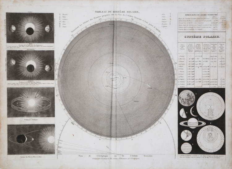
Celestial map with diagrams and tables of related solar system phenomena.
Plate taken from Atlas Classique De La Geographie Ancienne, Du Moyen Age Et Moderne, A l'Usage des Colleges et des Pensions, Pour Servir A L'Etude De La Geographie Et De L'Histoire, Par V. Monin, Ingenieur-Geographe, Membre De La Societe De Geographie. Nouvelle Edition, Augmentee D'Un Tableau Comparatif De La Hauteur Des Montagnes Et Du Cours Des Fleuves. Annee Scolaire 1838 Et 1839. Librairie Classique De Perisse Freres. Paris, Rue Du Pot - De - Fer - Saint - Sulpice, 8. Lyon, Grande Rue Merciere, 33. (on verso) ... Paris. - Impremerie De Decourchant, Rue D'Erfurth, printed in Paris 1839.
Charles V. Monin (1830 - 1880) was a French map publisher working the early to mid 19th century. A progressive printer, Monin was one of the first cartographic printers in Europe to take advantage of the newly discovered lithographic engraving process. His workshops in Paris and Caen, France, produced three important atlases as well as numerous independent issue maps. Monin was a member of La Sociéte de Géographie in Paris. He is known to have worked with other French map publishers including Vuillemin and Fremin.
Copperplate, light foxing, otherwise good condition.
Charles V. MONIN (attivo a Parigi 1830 - 1880)
|
Charles V. Monin (1830 - 1880) was a French map publisher working the early to mid 19th century. A progressive printer, Monin was one of the first cartographic printers in Europe to take advantage of the newly discovered lithographic engraving process. His workshops in Paris and Caen, France, produced three important atlases as well as numerous independent issue maps. Monin was a member of La Sociéte de Géographie in Paris. He is known to have worked with other French map publishers including Vuillemin and Fremin.
|