| Reference: | S35610 |
| Author | Thomas KITCHIN |
| Year: | 1794 |
| Zone: | Asia |
| Printed: | London |
| Measures: | 1220 x 1070 mm |
| Reference: | S35610 |
| Author | Thomas KITCHIN |
| Year: | 1794 |
| Zone: | Asia |
| Printed: | London |
| Measures: | 1220 x 1070 mm |
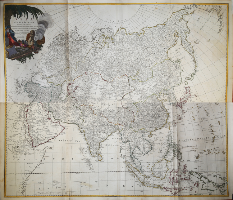
Asia and its Islands According to d'Anville; Divided into Empires, Kingdoms, States, Regions, &c. with the European possessions and settlements in the East Indies and an exact delineation of all the discoveries made in the eastern parts by the English under Captain Cook.
An absolutely extraordinary and monumental two-panel wall map of Asia from 1794, produced by J. B. B. d'Anville. It covers the entire Asian continent, including Arabia, the Indian subcontinent, and the East Indies. Maps by Cook, Bering (including Behring Island, where he died), and Tschirikow are prominently displayed in Siberia and East Asia. This map is exceptionally interesting for its detailed work on Central Asia, a little-known and largely unmapped region at the time. Southeast Asia and the islands of the East Indies are mapped in detail based on old Dutch maps, with only speculative commentary on the interior. Note the kingdoms of Pegu (Burma), Siam (Thailand), Tonkin and Chochin (Vietnam), and Cambodia (Cambodia). Further south, the Strait of Malacca and the Strait of Singapore are noted. The island of Singapore, though unidentified, is recognizable.
An elaborate decorative title cartouche in the upper left quadrant depicts a bearded merchant, possibly Ottoman, with his goods, an incense burner, and a camel under a palm tree.
Map from Thomas Kitchin's "Kitchin's General Atlas, describing the Whole Universe," a collection of some of the most accurate maps in existence, crafted with the utmost precision, and supplemented by the earlier edition by D'Anville and Robert with the works of many other eminent geographers. Published by Laurie & Whittle in London in 1797, the atlas contains 62 engravings, including 37 maps.
Etching, contemporary outline coloring, in excellent condition.
Bibliografia
R. Shirley, Maps in the atlases of the British Library, T.LAU-1c (1799 ed.).
|
English engraver and cartographer, who became hydrographer to the king. He was also an author, who wrote about the history of the West Indies.He produced John Elphinstone's map of Scotland (1746), Geographia Scotiae (1749), and The Small English Atlas (1749) with Thomas Jefferys. The Large English Atlas (with Bowen 1749–60) was a serious attempt to cover England at large scale. In 1755 Kitchin engraved the Mitchell Map map of North America.He worked for London Magazine. He produced 170 maps for London Magazine (1747–83). Kitchin was the head hydrographer for the King of England. Kitchin frequently stole the works of other cartographers, which is one reason why he "created" so much work as a cartographer.
|
|
English engraver and cartographer, who became hydrographer to the king. He was also an author, who wrote about the history of the West Indies.He produced John Elphinstone's map of Scotland (1746), Geographia Scotiae (1749), and The Small English Atlas (1749) with Thomas Jefferys. The Large English Atlas (with Bowen 1749–60) was a serious attempt to cover England at large scale. In 1755 Kitchin engraved the Mitchell Map map of North America.He worked for London Magazine. He produced 170 maps for London Magazine (1747–83). Kitchin was the head hydrographer for the King of England. Kitchin frequently stole the works of other cartographers, which is one reason why he "created" so much work as a cartographer.
|