| Reference: | S35574 |
| Author | Sebastian Münster |
| Year: | 1540 ca. |
| Zone: | Asia |
| Printed: | Basle |
| Measures: | 335 x 270 mm |
| Reference: | S35574 |
| Author | Sebastian Münster |
| Year: | 1540 ca. |
| Zone: | Asia |
| Printed: | Basle |
| Measures: | 335 x 270 mm |
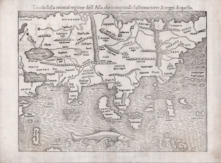
Nice example of this first printed map of the Asia, by Sebastian Munster.
The map shows Asia from the Caspian Sea and Persian Gulf to the Pacific. The Pacific Ocean shows an archipelago of 7448 islands, a forerunner to the better understanding of Southeast Asia, which is largely unrecognizeable, although Java Minor and Major, Porne (Borneo), Moluca and several other islands are named. The map does not include Japan, which appears on the map of America. The northeastern coast of Asia is also omitted. The map also includes a large sea monster and mermaid type creature.
Although largely based on Ptolemy's work, the map incorporates some of the more recent Portuguese discoveries. The outlines of the Indian subcontinent, between the Indus and the Ganges rivers are now in a more recognizable form, with "Zaylon" (Sri Lanka) correctly shown as an island. The Portuguese outpost sof Goa and Calicut, the first place where Vasco da Gama landed in 1497, are depicted. Further to the east "Taprobana" is also designated as "Sumatra.". The Portugese trading port of "Malaqua" is shown. Java is depicted as two separate islands. "Moloca," center of the spice island trade and the object of considerable conflict between Spain and Portugal is shown. The resolution of the dispute was the official purpose of Magellan's epic circumnavigation. The treatment of "Cathay" (China) is consistent with the writings of Marco Polo and other Venetian travellers.
Map taken from the Geographia universalis, vetus et nova, complectens. Claudii Ptolemaei Alexandrini Ennarationis libros VIII, published for the first time in 1540 in Basel by Heinrich Petri, stepson of Münster and his trusted printer.
The book is illustrated by 27 maps built following the indications of Ptolemy, which are flanked by 21 "modern" maps, outlined on the basis of recent geographical discoveries. The Geographia of Münster was a great success, and Petri reprinted it the following year (1541) and then in 1542..
Having increased the number of modern maps by six, including the Carta Marina of Olao Magnus describing Scandinavia, the publisher reprinted it again in 1545, in 1551 and finally in 1552, still with 54 maps, but with the substitution of Pomerania in place of Lake Constance. At the death of Münster the work was not reprinted; some of the maps were instead used by Heinrich Petri for the posthumous editions of the Cosmographiae Universalis. The woodblock of the maps, duly amended, were used for the Rerum Geographicarum of Strabo, edition printed in Basileae: Ex Officina Henricpetriana, 1571 Mense Augusto.
Woodcut, in excellent condition.
|
Parry, The Cartography of the East Indian Islands, pp.65-68, pl. 3.8
|
Sebastian Münster (1488 - 1552)
|
Sebastian Münster was a German cartographer, cosmographer, and Hebrew scholar whose Cosmographia (1544; "Cosmography") was the earliest German description of the world and a major work - after the Nuremberg Chronicle of 1493 - in the revival of geography in the 16th-century Europe. Altogether, about 40 editions of the Cosmographia appeared during 1544-1628. Although other cosmographies predate Münster's, he is given first place in historical discussions of this sort of publication, and was a major influence on his subject for over 200 years.
In nearly all works by Münster, his Cosmographia is given pride of place. Despite this, we still lack a detailed survey of its contents from edition to edition, along the years from 1544 to 1628, and an account of its influence on a wide range of scientific disciplines. Münster obtained the material for his book in three ways. He used all available literary sources. He tried to obtain original manuscript material for description of the countryside and of villages and towns. Finally, he obtained further material on his travels (primarily in south-west Germany, Switzerland, and Alsace). The Cosmographia contained not only the latest maps and views of many well-known cities, but included an encyclopaedic amount of details about the known - and unknown - world and undoubtedly must have been one of the most widely read books of its time.
Aside from the well-known maps and views present in the Cosmographia, the text is thickly sprinkled with vigorous woodcuts: portraits of kings and princes, costumes and occupations, habits and customs, flora and fauna, monsters and horrors. The 1614 and 1628 editions of Cosmographia are divided into nine books. Nearly all the sections, especially those dealing with history, were enlarged. Descriptions were extended, additional places included, errors rectified.
|
|
Parry, The Cartography of the East Indian Islands, pp.65-68, pl. 3.8
|
Sebastian Münster (1488 - 1552)
|
Sebastian Münster was a German cartographer, cosmographer, and Hebrew scholar whose Cosmographia (1544; "Cosmography") was the earliest German description of the world and a major work - after the Nuremberg Chronicle of 1493 - in the revival of geography in the 16th-century Europe. Altogether, about 40 editions of the Cosmographia appeared during 1544-1628. Although other cosmographies predate Münster's, he is given first place in historical discussions of this sort of publication, and was a major influence on his subject for over 200 years.
In nearly all works by Münster, his Cosmographia is given pride of place. Despite this, we still lack a detailed survey of its contents from edition to edition, along the years from 1544 to 1628, and an account of its influence on a wide range of scientific disciplines. Münster obtained the material for his book in three ways. He used all available literary sources. He tried to obtain original manuscript material for description of the countryside and of villages and towns. Finally, he obtained further material on his travels (primarily in south-west Germany, Switzerland, and Alsace). The Cosmographia contained not only the latest maps and views of many well-known cities, but included an encyclopaedic amount of details about the known - and unknown - world and undoubtedly must have been one of the most widely read books of its time.
Aside from the well-known maps and views present in the Cosmographia, the text is thickly sprinkled with vigorous woodcuts: portraits of kings and princes, costumes and occupations, habits and customs, flora and fauna, monsters and horrors. The 1614 and 1628 editions of Cosmographia are divided into nine books. Nearly all the sections, especially those dealing with history, were enlarged. Descriptions were extended, additional places included, errors rectified.
|