| Reference: | S36303 |
| Author | John SPEED |
| Year: | 1626 ca. |
| Zone: | Asia |
| Printed: | London |
| Measures: | 510 x 390 mm |
| Reference: | S36303 |
| Author | John SPEED |
| Year: | 1626 ca. |
| Zone: | Asia |
| Printed: | London |
| Measures: | 510 x 390 mm |
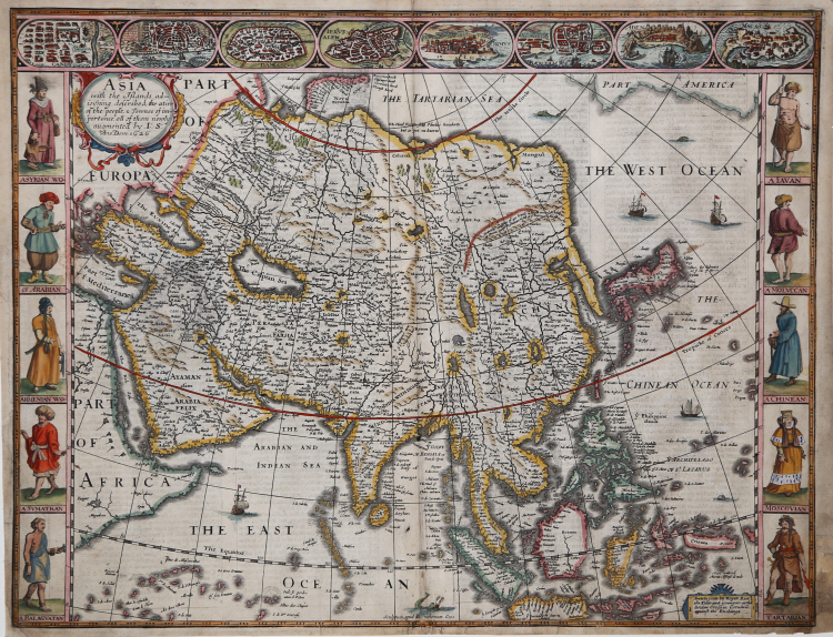
"This is the earliest English printed map of the continent of Asia" (Shirley). Second state (of 3) from the edition publish by the Reas in 1662 of Speed's "Prospect".
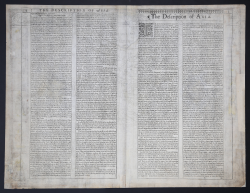
This beautiful carte-a-figures map is the first English printed map of Asia. It is flanked by costumed figures of Asian peoples with a series of eight city views forming a decorative frieze across the top including Damascus, Jerusalem, Aden, Hormus, Goa, Kandy, Banten and Macau. The map is based largely on Jodocus Hondius' map of 1623 with detailed depictions of the East Indies, the Philippines and the elongated peninsula form of Korea. Large lakes and rivers dominate the interior of China and the mythical Lake of Ciamay spawns five large rivers in India Without Ganges. The Great Wall of China is placed too far north. The Caspian Sea is greatly enlarged and oriented in an east-west direction. The map is further embellished with a title cartouche, numerous sea creatures and sailing ships and an elephant appears in the interior of China. Beautifully engraved by Abraham Goos with the imprint of Roger Rea, published in 1662. The English text on verso provides a fascinating Anglo-centric view of Asia.
Copperplate, light browning and some spotting in places, large brownish spot at left; light shine-through of text. Repairs to few small tears at bottom just affecting engraved area, and to small split at each lower corner and at left margin, generally in good condition.
|
Shirley T.SPE-2a-d; Sweet 30 mit Abb.; Tibbetts 76; Al Ankary 44.
|
|
John Speed (1552-1629) is the most famous of all English cartographers primarily as a result of The Theatre of the Empire of Great Britaine, the first atlas of the British Isles. The individual maps are the best known and most sought-after of all county maps. They were derived from the best up-to-date sources available; however, Speed did make innovations - introducing town plans, county boundaries, and embellishments such as the coats of arms of local Earls, Dukes, and the Royal Household. The overall effect is to produce very decorative, attractive and informative maps. Speed was also responsible for the first world atlas by an Englishman, The Prospect of the Most Famous Parts of the World (1627). The maps are famed for their borders consisting of local inhabitants in national costume and panoramic vignette views of major cities and towns. An added feature is that regular atlas copies have English text printed on the reverse, giving a charming description of life in the early seventeenth century of the region.
Little is known of Speed's personal life other than that he was born in 1552 the son of a Cheshire tailor who devoted his time to map making. In 1598 he was found a post in the Customs where, with Royal patronage, he was subsidized in map making. Through his work he became a member of such learned societies as the Society of Antiquaries and associated with the likes of William Camden Robert Cotton and William Lambarde. He died in 1629 at the age of seventy-seven.
|
|
Shirley T.SPE-2a-d; Sweet 30 mit Abb.; Tibbetts 76; Al Ankary 44.
|
|
John Speed (1552-1629) is the most famous of all English cartographers primarily as a result of The Theatre of the Empire of Great Britaine, the first atlas of the British Isles. The individual maps are the best known and most sought-after of all county maps. They were derived from the best up-to-date sources available; however, Speed did make innovations - introducing town plans, county boundaries, and embellishments such as the coats of arms of local Earls, Dukes, and the Royal Household. The overall effect is to produce very decorative, attractive and informative maps. Speed was also responsible for the first world atlas by an Englishman, The Prospect of the Most Famous Parts of the World (1627). The maps are famed for their borders consisting of local inhabitants in national costume and panoramic vignette views of major cities and towns. An added feature is that regular atlas copies have English text printed on the reverse, giving a charming description of life in the early seventeenth century of the region.
Little is known of Speed's personal life other than that he was born in 1552 the son of a Cheshire tailor who devoted his time to map making. In 1598 he was found a post in the Customs where, with Royal patronage, he was subsidized in map making. Through his work he became a member of such learned societies as the Society of Antiquaries and associated with the likes of William Camden Robert Cotton and William Lambarde. He died in 1629 at the age of seventy-seven.
|