
| Reference: | S39549 |
| Author | Adam Friedrich ZURNER |
| Year: | 1709 ca. |
| Zone: | America |
| Printed: | Amsterdam |
| Measures: | 590 x 505 mm |
| Reference: | S39549 |
| Author | Adam Friedrich ZURNER |
| Year: | 1709 ca. |
| Zone: | America |
| Printed: | Amsterdam |
| Measures: | 590 x 505 mm |
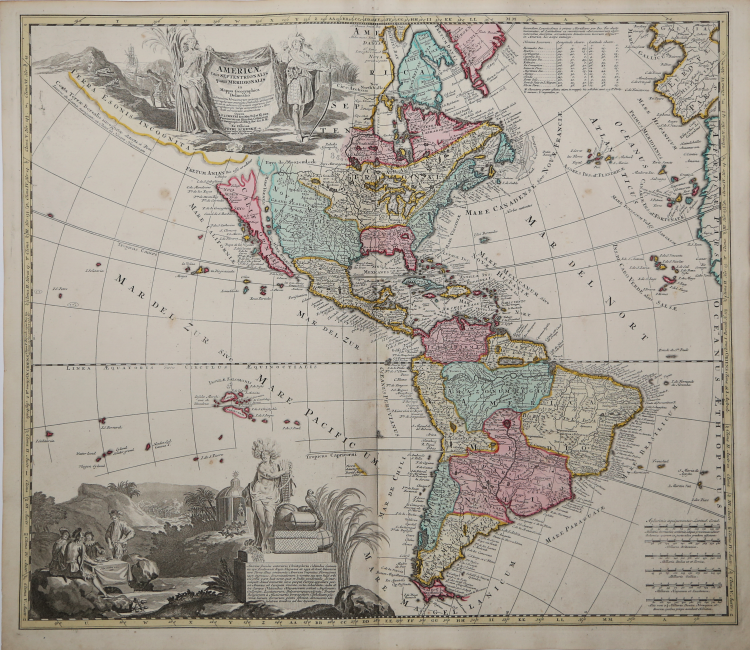
Scarce Zurner Map of America -- California shown as an Island.
Fine old color example of this scarce map of America, showing California as an island, published by Zurner and engraved by Pieter Schenk.
Zurner's map is a fascinating compilation of up to date information and cartographic myths. The main body of North America reflects corrected information, including De L'Isle's treatment of the Mississippi River Valley and the Rio Grande River properly flowing into the Gulf of Mexico. In depicting California as an Island, Zurner uses the Second Sanson model, but makes the Northeastern part of the Island very tentative in nature, clearly aware that other map makers have abandoned the myth of the island of California.
The map also shows a massive Terra Esonis Incognita, a vestage of the prior century, when popular (mythical) cartography showed a near continuous land bridge from the Straits of Anian to Japan. The Pays de Moozemlek is shown to the East of the Straits of Anian, a myth which would become very popular in the early 18th Century and would combine with Lahontan's mythical river to dominate the landscape of the region in the first part of the 18th Century.
Includes two beautiful allegorical cartouches, including a title cartouche, flanked by two Native Americans and large vignette at bottom showing explorers seated around a table, natives worshiping in a temple, and a battle. Latin text enclosed in the cartouche discusses the explorations of Columbus, and Catholic missions.
Copper engraving, contemporary colour, in perfect condition.
Adam Friedrich ZURNER (1679 - 1742)
|
Adam Friedrich Zürner was a German engraver, pastor and scientist based in Dresden Germany. His is known to have worked with the Homann Heirs firm as well as several other cartographic firms of the era. His cartographic work primarily focuses on Saxony and parts of Germany. Zurner's first project of note was a map of Saxony, for which he was retained by August III, King of Poland, in 1711.
Zurner was appointed Geographer of Poland and the Electorate of Saxony, a position in which he served until 1732. In this time period, he reportedly traveled nearly 18,000 miles and created over 900 maps.
In 1721, he was tasked with establishing a postal road system in Saxony and marking the distances with stone posts.
His work resulted in the Atlas Augusteus Sauronicus (40 maps plus key sheet), which remained incomplete until after Zurner's death, but was ultimately sold to Pieter Schenk in Amsterdam in about 1745. Schenk's completed work (49 maps, published in Amsterdam and Leipzig) was issued without reference to Zurner's name, under the title Atlas Saxonicus.
|