| Reference: | S33974 |
| Author | John SPEED |
| Year: | 1626 ca. |
| Zone: | The Americas |
| Printed: | London |
| Measures: | 520 x 460 mm |
| Reference: | S33974 |
| Author | John SPEED |
| Year: | 1626 ca. |
| Zone: | The Americas |
| Printed: | London |
| Measures: | 520 x 460 mm |
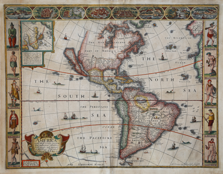
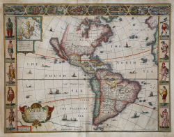
A nice example of John Speed's 1626 map of America here in its second state, with the cartographic additions of Boston, Conectacut, Lon Ile, Mary land and Carolina.
One of the most iconic maps of America ever made, this map is surrounded by decorative vignettes illustrating the indigenous peoples and cities of the Americas. This map is both beautiful and important. It features a number of first, including being the first atlas map to depict California as an island and to accurately depict the east coast of North America. Cartographically it follows on the earlier maps of the Dutchman Abraham Goos, the engraver, with updates to reflect the 1625 Briggs vision of an insular California.
This is the first atlas map to represent California as an island. The idea of an insular California first appeared as a work of fiction in Garci Rodriguez de Montalvo's c. 1510 romance Las Sergas de Esplandian, where he writes
Know, that on the right hand of the Indies there is an island called California very close to the side of the Terrestrial Paradise; and it is peopled by black women, without any man among them, for they live in the manner of Amazons.
Baja California was subsequently discovered in 1533 by Fortun Ximenez, who had been sent to the area by Hernan Cortez. When Cortez himself traveled to Baja, he must have had Montalvo's novel in mind, for he immediately claimed the 'Island of California' for the Spanish King. By the late 16th and early 17th century ample evidence had been amassed, through explorations of the region by Francisco de Ulloa, Hernando de Alarcon and others, that California was in fact a peninsula. However, by this time other factors were in play. Francis Drake had sailed north and claimed 'New Albion' (identified here on the northwest coast of California Island) near modern day Washington or Vancouver for England. The Spanish thus needed to promote Cortez's claim on the 'Island of California' to preempt English claims on the western coast of North America. Henry Briggs, an English mathematician, began promoting the idea of an insular California in 1622, citing the journals of Friar Antonio de la Ascension, who accompanied the 1602-03 Sebastian Vizcaino expedition. The significant influence of the Spanish crown on European cartographers caused a major resurgence of the Insular California theory. Just before this map was made Eusebio Kino, a Jesuit missionary, traveled overland from Mexico to California, proving conclusively the peninsularity of California. Even so, it was ultimately a 1747 royal decree from King Ferdinand VII of Spain that finally forced cartographers to give up on the alluring idea.
Other elements of interest in North America are the complete absence of the Great Lakes - which in 1626 had yet to be conceived of by any European cartographers. The Straits of Anian appear tenuously in the extreme northwest, just above California. Just east of the 'o' in 'California,' on the continental mainland, there is a curious ghosted in lake called the 'Lagueo de Oro.' We have found no references or explanation for this. None of the legendary kingdoms of gold, Quivara, Teguayo, Cibola, etc. are noted. The western portions of the Hudson Bay are unmapped - suggestive of their unexplored status. The addition of Long Island and Boston, in notably darker print, are important updates over the earliest editions.
South America offers much of interest including the mythical Lake Parimia, in Guiana. The legend of Parima is associated with the English adventurer Sir Walter Raleigh's search for El Dorado. Believing El Dorado to lie in the northern part of the Amazon, Raleigh sailed down the Orinoco River just before the onset of the rainy season. Reaching a remote tribal village, Raleigh noted canoes arriving bearing gold, silver, and other treasures. Asked where the gold came from, the natives replied, 'Manoa,' the term for the tribe to which the river traders belonged. Manoa, the natives claimed could be reached following a long river voyage southward to a Great Lake, called Parima. Raleigh and his associates immediately associated Manoa and Lake Parima with the golden kingdom of El Dorado, though they never visited the city or lake. Subsequent maps, including this one, mapped el Dorado and Lake Parima in this location for several hundred years. Both Raleigh and the natives were describing an actual event known to occur annually in the region. Rains would annually swell the Amazon and Orinoco river systems creating a linkage in the Rupununu flood plain, which, during heavy rains, can resemble a massive lake. The Manoa were a large and populous trading nation active in pre-colonial days whose vast empire, based in the Amazon Basin, extended form the Andes to the Orinoco. Curiously, in addition to noting the city of Manoa on Lake Parima, D'Anville also correctly maps the center of the ancient Manoan civilization between the Amazon tributaries Rio Negro and Rio Yapura. Sadly the Manoa and many of the other populous South American indigenous nations noted by the earliest explores to the region vanished, brought low by European epidemics.
Another mythical lake, Eupana, appears further south connecting the Rio de la Plata and the Paraguay River to the R. Real, thus turning eastern Brazil into an island. This is a update over many earlier maps which connected Eupana directly to the Amazon. Far in the south Speed presents us ith another anomaly, the Straits of Le Maire, which separates Tierra de Fuego from another mysterious stretch of land labled 'States Land.' The is in fact the modern island of Isla de los Estados, the southeastern most point in South America. Jacob le Maire and his pilot Willem Schouten passed to between this island and Tierra del Fuego on their 1615 voyage around Cape Horn and into the Pacific.
In the high Arctic, near Iceland and Greenland, the supposed islands of Frisland and Brasil are noted. Frisland is little more than a double mapping of Iceland. Brasil, also known as Hy-Brasil, is a phantom island north Atlantic just west of Ireland. In Irish myths it was said to be cloaked in mist, except for one day every seven years, when it became visible but still could not be reached. Little is known of this orgins of this myth, but it appears on maps in various forms from about 1325. The last known appearance was in 1865 when it appeared on a nautical chart as 'Brasil Rock.' Some speculate that it may be an early reference to Porcupine Bank, a shoal in the Atlantic Ocean about 200 kilometres (120 mi) west of Ireland.
Speed's map of America is especially noteworthy for its surrounded vignettes. To either side of the map proper there are various vignettes illustrating the indigenous peoples of the America. These includes natives of Greenland, Virginia, Florida, Mexico, New England, Peru, Brazil, and Tierra del Feugo.n Along the top of the map there are eight city views: Havanna, Santo Domingo, Cartagena, Mexico City, Cuzco, the isle of Moca, Rio de Janeiro, and Olinda.
This map was engraved for John Speed by Abraham Goos.
“This desirable map is the first published in an atlas to depict California as an island, and an accurate east coast of North America, particularly between Chesapeake Bay and Cape Cod. John Speed was a historian, but his most famous book is the Theatre of the Empire of Great Britaine, first published in 1611. This was an atlas of the British Isles that appeared in many editions. Before his death he produced A Prospect of the Most Famous Parts of the World. Although published separately it is most often found bound with the Theatre This work was the first general atlas of the world produced in England. For these maps, as with those earlier, Speed looked to the Low Countries, the center of the European map trade at the time, to have them engraved. This particular one was the work of Abraham Goos, who had spent time in London like many of the Dutch engravers.
Goos drew on his engraving of North America in 1624, and the Briggs 1625, to depict California as an island once more. He was the only Dutch cartographer to do so for some considerable time. There are five fewer placenames in California than the Briggs. However, like his earlier one he includes a similar faint north- west coastline and Strait of Anian. Brasil and Frisland, remnants from the sixteenth century, make a stubborn appearance in the North Atlantic. The fledgling colonies of Plymouth in New England, and lames Citti in Virginia, are both recognised. Decorating the whole are three attractive borders. The two sides illustrate the natives of the continent, the left bears those of the north, and the right those of the south. Despite the map's obvious attention to the English presence in North America, none of the eight towns represented in the third are from that part. This is owing to the relative lack of any contemporary views to draw upon.
The 1627 edition was published by George Humble, who reissued it in 1632. After his death in 1640, his eldest son, William, continued with an edition in 1646. It then appears that it was issued irregularly during the early 1650s still bearing a 1646 title page. Editions of the Theatre..., dated to between 1650 and 1654, are extremely rare. In about 1658-59 William Garrett acquired the plates and sold them on to Roger Rea, both the elder and younger. They updated this plate with the addition of Boston, Long Ile and other English nomenclature, and altered the imprint. Ashley Baynton-Williams has drawn the author's attention to an example of the map with the geographic alterations, but still bearing the Humble imprint. The Prospect was issued in 1662, and accompanied the British atlas until the death of one of the Reas in 1665, probably of the plague that was ravaging London at the time. This edition was largely destroyed in the Great Fire of London in 1666.
The plates were then acquired by Thomas Bassett and Richard Chiswell, who in 1676 published the most often seen edition. Sometime before 1690 they passed into the hands of Christopher Browne, possibly through Robert Walton whose stock Browne largely acquired. The Virginia and Maryland, map from the 1676 edition exists in a later state with Browne's imprint, but no example of the America in such a state is known. In the 1980s the British Library acquired a proof example of the Bermuda map which lacked the imprint of George Humble. This could suggest that these were added by another hand, after delivery of the copperplates to London.” (Burden " The Mapping of North America", p. 269).
A good example, with contemporary colour, small margins as usual, good condition.
Bibliografia:
Burden "The Mapping of North America", pp. 269-270, n. 217; McLaughlin 3; Tooley p113.
|
John Speed (1552-1629) is the most famous of all English cartographers primarily as a result of The Theatre of the Empire of Great Britaine, the first atlas of the British Isles. The individual maps are the best known and most sought-after of all county maps. They were derived from the best up-to-date sources available; however, Speed did make innovations - introducing town plans, county boundaries, and embellishments such as the coats of arms of local Earls, Dukes, and the Royal Household. The overall effect is to produce very decorative, attractive and informative maps. Speed was also responsible for the first world atlas by an Englishman, The Prospect of the Most Famous Parts of the World (1627). The maps are famed for their borders consisting of local inhabitants in national costume and panoramic vignette views of major cities and towns. An added feature is that regular atlas copies have English text printed on the reverse, giving a charming description of life in the early seventeenth century of the region.
Little is known of Speed's personal life other than that he was born in 1552 the son of a Cheshire tailor who devoted his time to map making. In 1598 he was found a post in the Customs where, with Royal patronage, he was subsidized in map making. Through his work he became a member of such learned societies as the Society of Antiquaries and associated with the likes of William Camden Robert Cotton and William Lambarde. He died in 1629 at the age of seventy-seven.
|
|
John Speed (1552-1629) is the most famous of all English cartographers primarily as a result of The Theatre of the Empire of Great Britaine, the first atlas of the British Isles. The individual maps are the best known and most sought-after of all county maps. They were derived from the best up-to-date sources available; however, Speed did make innovations - introducing town plans, county boundaries, and embellishments such as the coats of arms of local Earls, Dukes, and the Royal Household. The overall effect is to produce very decorative, attractive and informative maps. Speed was also responsible for the first world atlas by an Englishman, The Prospect of the Most Famous Parts of the World (1627). The maps are famed for their borders consisting of local inhabitants in national costume and panoramic vignette views of major cities and towns. An added feature is that regular atlas copies have English text printed on the reverse, giving a charming description of life in the early seventeenth century of the region.
Little is known of Speed's personal life other than that he was born in 1552 the son of a Cheshire tailor who devoted his time to map making. In 1598 he was found a post in the Customs where, with Royal patronage, he was subsidized in map making. Through his work he became a member of such learned societies as the Society of Antiquaries and associated with the likes of William Camden Robert Cotton and William Lambarde. He died in 1629 at the age of seventy-seven.
|