| Reference: | A54486 |
| Author | Henri Abraham CHATELAIN |
| Year: | 1719 |
| Zone: | The World |
| Printed: | Amsterdam |
| Measures: | 1440 x 830 mm |
| Reference: | A54486 |
| Author | Henri Abraham CHATELAIN |
| Year: | 1719 |
| Zone: | The World |
| Printed: | Amsterdam |
| Measures: | 1440 x 830 mm |
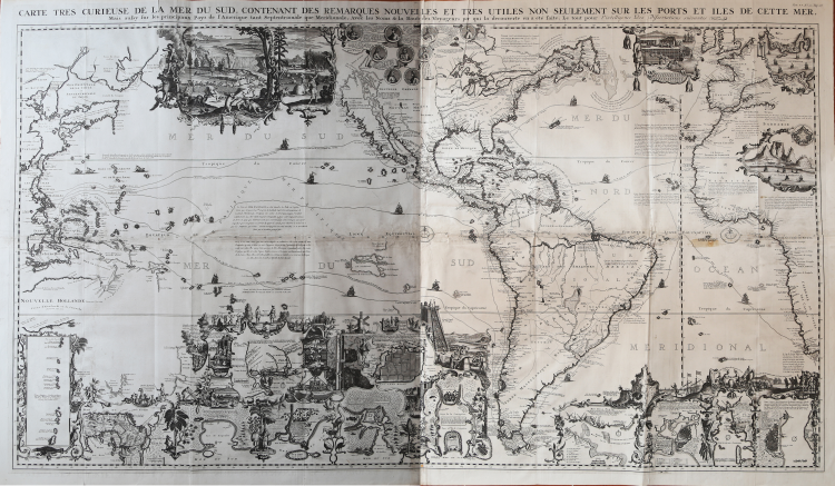
Carte Tres Curieuse De La Mer Du Sud Contenant Des Remarques Nouvelles Et Tres Utiles Non Seulement Sur Les Ports et Isles de Cette Mer, Mais aussy sur les principaux Pays de l'Amerique tant Septentrionale que Meridionale, Avec les Noms & la Route des Voyageurs . .
Chatelain's "Carte Tres Curieuse" is one of the most spectacular examples of the marriage of cartography and graphic art. Richly decorated in the tradition of Dutch cartography, this map extends from East Asia to Western Europe, with particular attention to the Pacific Ocean and the Americas.
Composed of 4 sheets, it was published by Henri Abraham Chatelain (1684-1743, a Huguenot pastor of Parisian origins) and is based on a very rare map composed of 10 sheets by Nicolas De Fer, published in 1713; it offers an extraordinary graphic representation of the Age of Discoveries and the characteristics of the New World.
Its elaborate illustrations provide a panorama of the Age of Discoveries, depicting the customs, rituals and practices of the indigenous peoples, considered exotic by Europeans at the time. It also illustrates historical episodes, the flora and fauna of the New World and portraits of the great discoverers. Two of the most important illustrations depict an unusually industrious and human-like beaver colony and the sun-drying of cod in Newfoundland. Both of these activities were pillars of the early North American economy. The map was engraved by Bernard Picart.
With its lush imagery, it can also be seen as the cartographer's attempt to stimulate interest in pan-Pacific trade. The presentation of a miniature Pacific Ocean, with shipping lanes showing direct and easy crossings, certainly makes the ocean seem less hostile. The map also includes much of the eastern Pacific, making it clear that vast territories would be accessible via Pacific voyages. And the hyper-rich imagery also suggests the potential fruits of such effort.
From the Atlas Historique, published in Amsterdam between 1705 and 1720. This map is included in the sixth volume of 1719.
Henri Abraham Chatelain (1684 - 1743) was a Huguenot pastor of Parisian origins. He is best known as a Dutch cartographer, and more specifically for his cartographic contributions to the seven-volume Atlas Historique, published in Amsterdam between 1705 and 1720. Innovative for its time, the Atlas Historique combined engravings and artwork with studies of geography, history, ethnology, heraldry, and cosmography. Some scholars suggest that the Atlas Historique was not compiled solely by Henri Chatelain, as is commonly believed, but rather was a family enterprise involving Henri, his father Zacharie, and his brother Zacharie.
A recent article by Jan W. van Waning in the Imcos Journal entitled "Chatelain’s Atlas Historique New evidence of its authorship" (Spring 2010, no. 120, pp. 7-15) argues that the compiler of the seven-volume work, in which this map was published, was Zacharie Chatelain, and not the usually cited Henry Abraham.
Etching, printed on four large sheets of contemporary laid paper, originally joined and folded several times, traces of glue in the folds (on the back), minimal tears in the centre due to folding, otherwise in excellent condition.
Bibliografia
Schwartz/Ehrenberg, pp. 146-47, pl. 85; Tooley, Mapping of America, p. 130; Leighly, California as an Island, pl. xx; Mclaughlin 190.
Henri Abraham CHATELAIN (1684 - 1743)
|
Henri Abraham Chatelain (1684 - 1743) was a Huguenot pastor of Parisian origins. He is best known as a Dutch cartographer and more specifically for his cartographic contribution in the seminal seven volume Atlas Historique, published in Amsterdam between 1705 and 1720. Innovative for its time, the Atlas Historique combined fine engraving and artwork with scholarly studies of geography, history, ethnology, heraldry, and cosmography. Some scholarship suggests that the Atlas Historique was not exclusively compiled by Henri Chatelain, as is commonly believed, but rather was a family enterprise involving Henri, his father Zacharie and his brother, also Zacharie. The Atlas Historique published by Chatelain was part of a major work of its time, an encyclopaedia in seven volumes including geography as one of its main subjectes. The text was by Nicholas Gueudeville and the maps by Chatelain. The Atlas included one of the finest maps of America (4 sheets) surrounded by vignettes and decorative insets.
1705-20 Atlas Historique:Amsterdam (maps by Chatelain based on G.Delisle)
Further issues to 1739
|