| Reference: | S39545 |
| Author | Adam Friedrich ZURNER |
| Year: | 1700 ca. |
| Zone: | Africa |
| Printed: | Amsterdam |
| Measures: | 590 x 510 mm |
| Reference: | S39545 |
| Author | Adam Friedrich ZURNER |
| Year: | 1700 ca. |
| Zone: | Africa |
| Printed: | Amsterdam |
| Measures: | 590 x 510 mm |
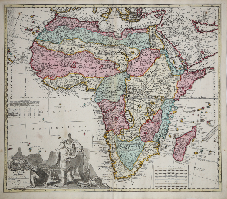
Copper engraving old coloured from Atlas Contractus sive Mapparum Geographicarum Sansoniarum auctarum et correctarum Nova Congeries. Amsterdam, P. Schenk, c. 1700.
An attractive and detailed map of Africa drawn up by Adam Freidrich Zürner (1680-1742) which first appeared in the "Atlas Contractus" published in 1709 by Schenk. With a very impressive decorative cartouche to the bottom left hand corner, with the title inscribed on a masonry block surmounted by a lion which snarls at an enormous crocodile on its right. Also depicted in the title cartouche are a native holding a cornucopia whilst riding an elephant, pyramids, a woman milking a cow and a fat-tailed sheep.
On the lower left, decorative cartouche with title and figures of habitants and local fauna, including a crocodile, a lion and an elephant.
|
Norwich " Maps of Africa" Map 66.
|
Adam Friedrich ZURNER (1679 - 1742)
|
Adam Friedrich Zürner was a German engraver, pastor and scientist based in Dresden Germany. His is known to have worked with the Homann Heirs firm as well as several other cartographic firms of the era. His cartographic work primarily focuses on Saxony and parts of Germany. Zurner's first project of note was a map of Saxony, for which he was retained by August III, King of Poland, in 1711.
Zurner was appointed Geographer of Poland and the Electorate of Saxony, a position in which he served until 1732. In this time period, he reportedly traveled nearly 18,000 miles and created over 900 maps.
In 1721, he was tasked with establishing a postal road system in Saxony and marking the distances with stone posts.
His work resulted in the Atlas Augusteus Sauronicus (40 maps plus key sheet), which remained incomplete until after Zurner's death, but was ultimately sold to Pieter Schenk in Amsterdam in about 1745. Schenk's completed work (49 maps, published in Amsterdam and Leipzig) was issued without reference to Zurner's name, under the title Atlas Saxonicus.
|
|
Norwich " Maps of Africa" Map 66.
|
Adam Friedrich ZURNER (1679 - 1742)
|
Adam Friedrich Zürner was a German engraver, pastor and scientist based in Dresden Germany. His is known to have worked with the Homann Heirs firm as well as several other cartographic firms of the era. His cartographic work primarily focuses on Saxony and parts of Germany. Zurner's first project of note was a map of Saxony, for which he was retained by August III, King of Poland, in 1711.
Zurner was appointed Geographer of Poland and the Electorate of Saxony, a position in which he served until 1732. In this time period, he reportedly traveled nearly 18,000 miles and created over 900 maps.
In 1721, he was tasked with establishing a postal road system in Saxony and marking the distances with stone posts.
His work resulted in the Atlas Augusteus Sauronicus (40 maps plus key sheet), which remained incomplete until after Zurner's death, but was ultimately sold to Pieter Schenk in Amsterdam in about 1745. Schenk's completed work (49 maps, published in Amsterdam and Leipzig) was issued without reference to Zurner's name, under the title Atlas Saxonicus.
|