| Reference: | mms1279 |
| Author | Vincenzo CORONELLI |
| Year: | 1690 ca. |
| Zone: | Africa |
| Printed: | Venice |
| Measures: | 860 x 590 mm |
| Reference: | mms1279 |
| Author | Vincenzo CORONELLI |
| Year: | 1690 ca. |
| Zone: | Africa |
| Printed: | Venice |
| Measures: | 860 x 590 mm |
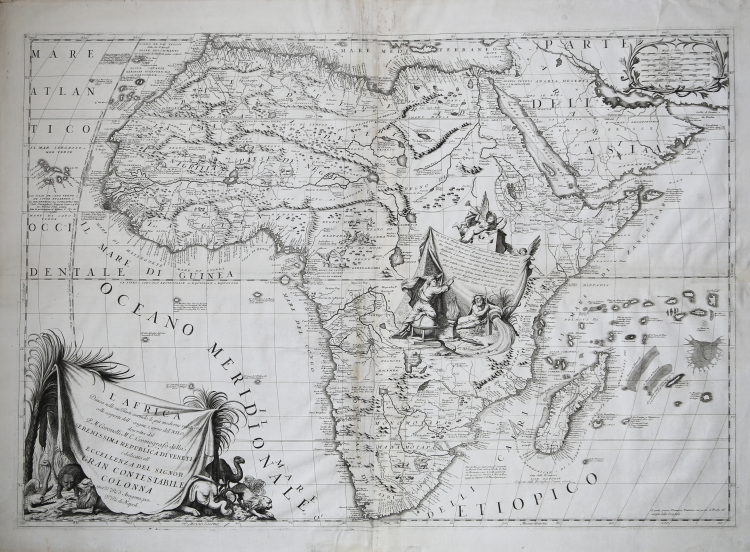
Large map of the continent, in two imperial sheets, joined in the past. First state of this map, published for the first time in volume one of Atlante Veneto. Coronelli's map contains up-to-date information on Africa. The basic models used are the maps of africa by Sanson (1668), Jaillot (1674), and Duval (1678).
The map bears a big cartouche on lower left depicting typical animals of Africa behind palm trees. Another cartouche can be seen right in the centre of the map, at the springs of the river Nile.
In this cartouche, decorated with an angel and the statue of the god Nile, have been included some information about the springs and the course of the river that had been discovered before the publication.
Copperplate, small signs of wear and tear on centre fold, in general in good condition. Extremely decorative map.
Example taken form Coronelli’s Atlante Veneto, Nel quale si contiene la Descrittione Geografica, Storica, Sacra, Profana e Politica degli Imperi, Regni, Provincie, e Santi dell’Universo […] In Venetia MDCXC.
Coronelli lived a period of extraordinary editorial fecundity starting from 1689, when he had the chair of geography at the University at the Procuratie, with the publication, in 1690, of the first volume of the Atlante Veneto. Under the name of Atlante Veneto goes the entire collection of thirteen works composed over the next decade, from the Isolario to the Specchio del mare.
The work was intended as an extension of Blaeu’s Atlas Maior. It is no mere collection of maps, but rather “a compendium of geographical, cosmographical, and scientific information... on contemporary Italian science and geography” (Scammell). As well as maps, the first volume includes several of Coronelli’s celebrated naval plates, many with the separately-printed “Farnese” borders especially commissioned by Coronelli’s patron, Ranuccio II Farnese, Duke of Parma.
Literature
Ermanno Armao, Vincenzo Coronelli (Florence, 1944), no.59, no.60 and p.237.
|
O. I. Norwich, "Norwich's Maps of Africa", map 56; R. L. Betz "The Mapping of Africa…" (2007), map 153
|
Vincenzo CORONELLI (Venezia 1650 - 1718)
|
Cosmographer, geographer, biographer, encyclopedist, globe maker, inventor, expert of engeneering and hydraulics. Extraordinarily versatile mind and an extremely tireless man, he produced more than 140 pieces in different genres. At the age of 15, he entered the Franciscan Order, which he then guided as Gran Generale from 1699. He became famous as geographer and mathematician, awakening the interest in these subjects in Italy at the end of the XVII century. He travelled a lot, seeking for all that was new, and keeping a correspondance with the most important intellectuals of his time. In 1681 Louis XIV wanted him to go to France, to entrust him with the task of making two terraqueous globes (Marly Globes), with a diameter of 4 metres. Once he came back to Italy, in 1685, he became Cosmographer of the Venetian Republic, where he taught geography and founded the first geographic accademy, called The Argonauts Accademy. In his whole life he produced more that 500 maps; some of them can be found in his most famous works, such as the Venetian Atlas (1690), the Island Book of the Venetian Atlas (1696-97), the Book of Globes (1693). As far as his scientific method, he didn’t elaborate new cartographic systems, but followed the theories that were considered most popular and effective at his time, based on the Copernican system. The main characteristic of his charts is the high quantity of toponymic and historical information. In his most famous and dense work, the Venetian Atlas, we can find about 1100 plates, 200 of which are extremely technical and this is the reason why it is considered the first Italian atlas to describe and illustrate the whole world with charts and maps. It was published in 13 volumes, starting from 1690, and it took nearly ten years to finish it. It is divided in different parts, the most important are the Atlas itself, then the Island Book, the Corso Geografico and the Teatro delle città.
|
|
O. I. Norwich, "Norwich's Maps of Africa", map 56; R. L. Betz "The Mapping of Africa…" (2007), map 153
|
Vincenzo CORONELLI (Venezia 1650 - 1718)
|
Cosmographer, geographer, biographer, encyclopedist, globe maker, inventor, expert of engeneering and hydraulics. Extraordinarily versatile mind and an extremely tireless man, he produced more than 140 pieces in different genres. At the age of 15, he entered the Franciscan Order, which he then guided as Gran Generale from 1699. He became famous as geographer and mathematician, awakening the interest in these subjects in Italy at the end of the XVII century. He travelled a lot, seeking for all that was new, and keeping a correspondance with the most important intellectuals of his time. In 1681 Louis XIV wanted him to go to France, to entrust him with the task of making two terraqueous globes (Marly Globes), with a diameter of 4 metres. Once he came back to Italy, in 1685, he became Cosmographer of the Venetian Republic, where he taught geography and founded the first geographic accademy, called The Argonauts Accademy. In his whole life he produced more that 500 maps; some of them can be found in his most famous works, such as the Venetian Atlas (1690), the Island Book of the Venetian Atlas (1696-97), the Book of Globes (1693). As far as his scientific method, he didn’t elaborate new cartographic systems, but followed the theories that were considered most popular and effective at his time, based on the Copernican system. The main characteristic of his charts is the high quantity of toponymic and historical information. In his most famous and dense work, the Venetian Atlas, we can find about 1100 plates, 200 of which are extremely technical and this is the reason why it is considered the first Italian atlas to describe and illustrate the whole world with charts and maps. It was published in 13 volumes, starting from 1690, and it took nearly ten years to finish it. It is divided in different parts, the most important are the Atlas itself, then the Island Book, the Corso Geografico and the Teatro delle città.
|