
| Reference: | MMS1012 |
| Author | Hendrick HONDIUS |
| Year: | 1641 ca. |
| Zone: | Africa |
| Printed: | Amsterdam |
| Measures: | 500 x 380 mm |
| Reference: | MMS1012 |
| Author | Hendrick HONDIUS |
| Year: | 1641 ca. |
| Zone: | Africa |
| Printed: | Amsterdam |
| Measures: | 500 x 380 mm |
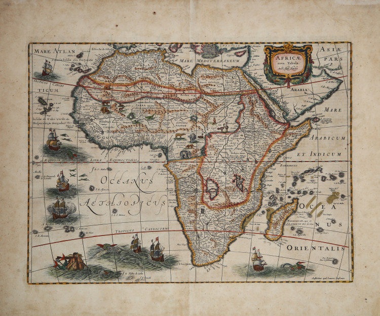
This map of Africa, realized by Hendrik Hondius, is a reissue of Jodocus Hondius' map, without the decorative borders, but with the excudit of Janssonius, on lower right.
While the general geography for this map is taken from Willem Blaeu’s wall map of 1608 and his 1617 folio map, this example represents a considerable advance in the detail and accuracy of Africa from Hondius’ prior maps.
Geographical improvements include a more rounded southern Cape, the naming of the Rio de Spiritu Santo and of the CuamaRiver, the insertion of Zimbaos and alteration in the shape of Madagascar. The Kingdom of Monomotapa fills the entire southern tip of Africa.
However, the map is also filled with fictitious rivers and mountains and shows the origin of the Nile conforming to the Ptolemaic tradition of twin lakes located below the equator, as is typical of 17th Century cartography.
Map taken from the Atlas sive cosmographicae meditationes de fabrica mundi edited by Hendrick Hondius.
In 1604, Jodocus Hondius (1563-1612) – probably trought Cornelis Claesz - bought the copperplates of Mercator’s Atlas sive cosmographicae meditationes de fabrica mundi at the auction of Gerard Jr.’s effects. He added about 40 maps, including new maps of the Continents and important regional maps of the Americas, before publishing a new edition of the Atlas, in 1606, in competition with Ortelius’ Theatrum Orbis Terrarum. As many of the maps were more up-to-date, the Mercator-Hondius Atlas effectively superseded Ortelius’ Theatrum. This atlas from 1606 include all 107 maps from the 1595 edition, as well as 37 new maps, skillfully engraved by Hondius, of various authors.
The second edition of the Mercator-Hondius atlas followed as soon as 1607/08. The first edition in another language, French, was put on the market in 1609. Apparently this one was regarded as the third edition, because in 1611 Editio Quarta appeared with a total of 150 maps. After the death of Jodocus Hondius in 1612 his widow and sons continued the publication of the Atlas. For instance Jodocus Junior (1594-1629) produced several new editions of the Editio Quarta between 1613 and 1619, each with the same 150 maps. Finally in 1619 the last edition of this atlas followed, to which six new maps were added. After 1620 the publication of the Atlas was continued by Henricus Hondius (ca. 1596/97-1651), the second son of Jodocus senior. Various editions appeared, in 1623, 1628 and 1630. Henricus Hondius was the first to make some real changes: in the 1628 edition he provided some Mercator maps with his own name. In 1630, when he was probably already cooperating with his brother-in- law Johannes Janssonius, Henricus added nine new maps.
Copperplate, fine original colouring, good condition.
|
O. I. Norwich, "Norwich's Maps of Africa", map 34; R. L. Betz "The Mapping of Africa…" (2007), map 58; Schilder, Monumenta, volume 6, 13.
|
Hendrick HONDIUS (Amsterdam 1597 - 1651)
|
Son of Jodocus Hondius (1563-1612) - engraver, cartographer, printer and publisher - in 1627 he began working in the family publishing business, managed, after the death of his father, by his mother and the printer Johannes Janssonius, who in 1612 had married Hendrick's (lat. Henricus) sister, Elisabeth. The Hondius typography was one of the most important of the time, even thanks to the collection of Mercator’s plates and the pubbication of many charts and atlases. In 1604, Hondius bought the copperplates of Mercator’s Atlas at the auction of Gerard Jr.’s effects. He added another forty maps, including new maps of the Continents and important regional maps of the Americas, before publishing a new edition of the Atlas, in 1606, in competition with Ortelius’ Theatrum. As many of the maps were more up-to-date, the Mercator-Hondius Atlas effectively superseded Ortelius’ Theatrum. On his death in 1612 his widow, Coletta van den Keere continued the business; from 1619 onwards their son Henry (II) (1597-1651) took over. From 1633 publication was carried on in co-operation with Jan Jansson Jr., Henry’s brother-in-law.
|
|
O. I. Norwich, "Norwich's Maps of Africa", map 34; R. L. Betz "The Mapping of Africa…" (2007), map 58; Schilder, Monumenta, volume 6, 13.
|
Hendrick HONDIUS (Amsterdam 1597 - 1651)
|
Son of Jodocus Hondius (1563-1612) - engraver, cartographer, printer and publisher - in 1627 he began working in the family publishing business, managed, after the death of his father, by his mother and the printer Johannes Janssonius, who in 1612 had married Hendrick's (lat. Henricus) sister, Elisabeth. The Hondius typography was one of the most important of the time, even thanks to the collection of Mercator’s plates and the pubbication of many charts and atlases. In 1604, Hondius bought the copperplates of Mercator’s Atlas at the auction of Gerard Jr.’s effects. He added another forty maps, including new maps of the Continents and important regional maps of the Americas, before publishing a new edition of the Atlas, in 1606, in competition with Ortelius’ Theatrum. As many of the maps were more up-to-date, the Mercator-Hondius Atlas effectively superseded Ortelius’ Theatrum. On his death in 1612 his widow, Coletta van den Keere continued the business; from 1619 onwards their son Henry (II) (1597-1651) took over. From 1633 publication was carried on in co-operation with Jan Jansson Jr., Henry’s brother-in-law.
|