
| Reference: | 4083 |
| Author | Giovanni Antonio MAGINI |
| Year: | 1595 ca. |
| Zone: | Abruzzi |
| Printed: | Bologna |
| Measures: | 460 x 350 mm |
| Reference: | 4083 |
| Author | Giovanni Antonio MAGINI |
| Year: | 1595 ca. |
| Zone: | Abruzzi |
| Printed: | Bologna |
| Measures: | 460 x 350 mm |
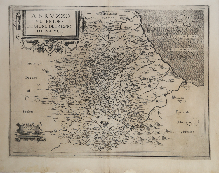
First and very rare version of Magini's map of Abruzzo Ulteriore, previous to the one that his son, Fabio, published as a posthumous work in L’Italia di Giovanni Antonio Magini, Bologna, 1620.
All the maps of the atlas had been already published before 1620, though in their temporary versions; they were corrected and updated before the final edition. These examples are quite rare, sometimes available on the market, and bear essential differences with those published in the atlas.
The main difference about this map is the lack of the cartouche, added later on lower right. The map derives directly from the one realized by Natale Bonifacio in 1587, though here less information are shown. To engrave his plates, Magini called two among the most famous artists of his time: the Belgian engraver Arnorldo Arnoldi and the English Benjamin Wright.
Copper engravings, laid on collector's paper, minor imperfections on lower white margins, otherwise in good condition.
Giovanni Antonio MAGINI (1555 - 1617)
|
Giovanni Antonio Magini was born in Padua in 1555, dedicating himself to the study of astronomy from an early age. In 1588 the Senate of Bologna appointed him Lecturer of Astronomy at the local University, choosing him instead of Galileo Galilei. His friendship with the Duke of Mantua, Vincenzo Gonzaga, helped Magini in his quest to obtain cartographical material for map-making from the various sovereigns ruling the different Italian states at that time. Because of Magini's early death in 1617, this effort was made famous by his son Fabio when he published the atlas "L'Italia" in Bologna in 1620. This is the first example of an Italian atlas and is made up of 24 pages of descriptive text and 61 maps of the Italian peninsula. Although this work was published posthumously, it can be entirely ascribed to Magini. He began drawing this maps around 1594, with the one depicting Bologna and its surrounding territories being the first. They were all printed before 1620 in draft editions which were then revised and updated for the final version. These draft proofs are extremely rare, although sometimes available for sale, and exhibit substantial differences in respect to the maps finally included in the atlas. Two of the most famous engravers of the time, Arnoldo Arnoldi and the englishman Benjamin Wright, were entrusted by Magini to engrave the plates. As we shall see in the presentation of the separate maps, they derive from different sources, both known and unknown, and therefore represent the result of an original work of critical analysis and compilation. This atlas had an important influence on the cartography of the italian peninsula for the following two centuries, beginning from Ortelius and going on to the principal dutch cartographers and editors.
|