| Reference: | S40999 |
| Author | Giovanni Antonio MAGINI |
| Year: | 1595 ca. |
| Zone: | Abruzzo |
| Printed: | Bologna |
| Measures: | 465 x 355 mm |
| Reference: | S40999 |
| Author | Giovanni Antonio MAGINI |
| Year: | 1595 ca. |
| Zone: | Abruzzo |
| Printed: | Bologna |
| Measures: | 465 x 355 mm |
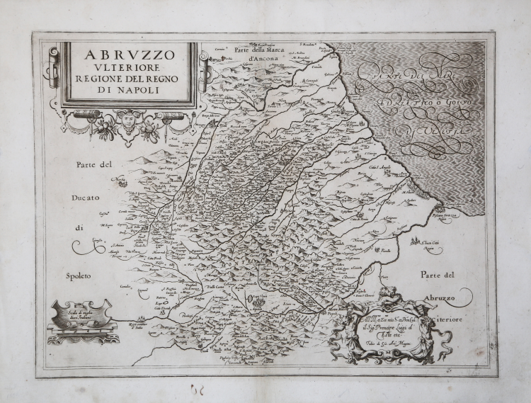
A sinistra, in alto nel cartiglio, troviamo il titolo ABRUZZO ULTERIORE REGIONE DEL REGNO DI NAPOLI. Nel piccolo cartiglio in basso la scala grafica Scala di Miglia dieci Italiane (10 miglia pari a mm 60). In basso a destra è inciso un cartiglio con la dedica All’ Ill.mo et Ecc.mo mio S.r et P[at]ron[us] Col.o il Sig.r Prencipe Luigi d’Este etc. segue l’imprint editoriale Fabio di Gio[vanni] Ant.o Magini.
Carta priva di orientazione e graduazione ai margini.
La carta deriva direttamente da quella realizzata da Natale Bonifacio nel 1587, rispetto alla quale presenta però meno informazioni. Probabile quindi che il Magini, come per tutte le carte del Regno di Napoli, si ispirò al rilievo ufficiale eseguito dallo studioso nolano Niccolò Antonio Stigliola il collaborazione con il cartografo viterbese Mario Cartaro, che tra il 1583 ed il 1594 ebbero l’incarico di realizzare una grande carta del reame.
Esemplare di secondo stato, con aggiunto il cartiglio in basso a destra – che contiene la dedica di Fabio Magini al principe Luigi d’Este. Per un esemplare di primo stato consultare la nostra scheda https://www.antiquarius.it/it/abruzzo/3193-abruzzo-ulteriore-regione-del-regno-di-napoli.html
Tavola tratta dal L’Italia a cura di Fabio Magini, edito a Bologna nel 1620, tre anni dopo la prematura morte del padre.
Composto da un breve testo descrittivo di sole 24 carte, l’opera è corredata di 61 carte geografiche della penisola, e costituisce il primo esempio di atlante italiano. L’opera è per intero di mano del Magini, che iniziò la realizzazione delle carte nel 1594 circa, dando alla luce per prima nel 1595 la carta del territorio di Bologna. Tutte le carte vennero alle stampe quindi prima del 1620, nelle loro stesure provvisorie, successivamente corrette ed aggiornate per l’edizione definitiva. Per la realizzazione delle lastre il Magini si servì di due dei più famosi intagliatori dell’epoca: il belga Arnoldo Arnoldi e l’inglese Benjamin Wright.
Incisione in rame, in ottimo stato di conservazione.
Bibliografia
Almagià, L'Italia di Giovanni Antonio Magini e la Cartografia dell'Italia nei secoli XVI e XVII (1922), pp. 73-78, n. 20.
Giovanni Antonio MAGINI (1555 - 1617)
|
Giovanni Antonio Magini was born in Padua in 1555, dedicating himself to the study of astronomy from an early age. In 1588 the Senate of Bologna appointed him Lecturer of Astronomy at the local University, choosing him instead of Galileo Galilei. His friendship with the Duke of Mantua, Vincenzo Gonzaga, helped Magini in his quest to obtain cartographical material for map-making from the various sovereigns ruling the different Italian states at that time. Because of Magini's early death in 1617, this effort was made famous by his son Fabio when he published the atlas "L'Italia" in Bologna in 1620. This is the first example of an Italian atlas and is made up of 24 pages of descriptive text and 61 maps of the Italian peninsula. Although this work was published posthumously, it can be entirely ascribed to Magini. He began drawing this maps around 1594, with the one depicting Bologna and its surrounding territories being the first. They were all printed before 1620 in draft editions which were then revised and updated for the final version. These draft proofs are extremely rare, although sometimes available for sale, and exhibit substantial differences in respect to the maps finally included in the atlas. Two of the most famous engravers of the time, Arnoldo Arnoldi and the englishman Benjamin Wright, were entrusted by Magini to engrave the plates. As we shall see in the presentation of the separate maps, they derive from different sources, both known and unknown, and therefore represent the result of an original work of critical analysis and compilation. This atlas had an important influence on the cartography of the italian peninsula for the following two centuries, beginning from Ortelius and going on to the principal dutch cartographers and editors.
|