| Reference: | MS6683 |
| Author | Jacques Nicolas BELLIN |
| Year: | 1772 |
| Zone: | Marmara |
| Measures: | 920 x 605 mm |
| Reference: | MS6683 |
| Author | Jacques Nicolas BELLIN |
| Year: | 1772 |
| Zone: | Marmara |
| Measures: | 920 x 605 mm |
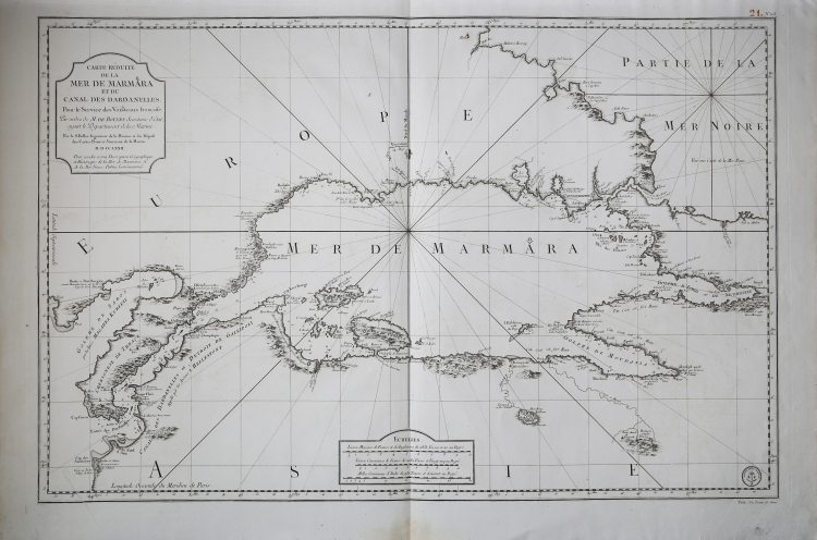
Carte Reduite de la Mer de Marmara et du Canal Des Dardanelles Pour le Service des Vaisseaux du Roy Par ordre de M. de Boynes Secretaire d'Etat, ayant, le Departement de la Marine . . . M.D.CC.LXXII . . .
Fine example of J.N. Bellin's map of the Sea of Marmara and the Dardanelle Straits, published in L'Hydrographie Francoise Recueil des Cartes Generales et Particulieres qui ont ete Faites pour le Service des Vaisseaux du Roy. Par ordre des Ministres de la Marine (1737-1765 circa)-
The map illustrates not only coastal features (soundings, anchorages, channels, etc.), but also gives a detailed accounting of the topographical features along the coastline and occasionally further into the interior. The map extends in scope from the Black Sea to the Mediterranean Sea.
The author of the chart is listed as J. N. Bellin, at the time director of the Dépôt des cartes et plans de la Marine, a cartographic service office created in 1720 by Philippe d'Orléans (1674-1723) that, anticipating today's French naval hydrographic and oceanographic service (SHOM), was tasked with collecting and preserving nautical plans, maps, journals and memoirs related to the Navy. The Dépôt des cartes et plans de la Marine was started in 1720, with the acquisition of the Neptune François, under the direction of Captain Charles-Hercule d'Albert de Luynes-known as Chevalier de Luynes (1674-1734)-an aristocrat and naval officer, who directed the institute until 1722.
The Dépôt des cartes et plans de la Marine quickly became the place where charts were produced. In 1773 he obtained a monopoly on the creation of nautical charts in France. As can be seen from the acts of the King's Council of October 5, 1773: "His Majesty had ordered in 1720 the establishment of a repository of charts, journals and maritime memoirs, astronomical observations and topographical operations, from which better maps than those previously used have already been made [...] His Majesty in his council, has ordered and orders: that in the future, all maps, pilot books, and instructions necessary for the conduct of both the merchantman and merchant ships of the kingdom, shall be composed, compiled, and published exclusively at His Majesty's repository by persons capable of acquitting themselves therefrom [...] consequently, no particular, scientist, geographer, hydrographer, naval officer, pilot, shall be able to publish such works without an express commission."
Copperplate engraving, with margins, in very good condition.
Bibliografia: cfr. O. Chapuis, A la mer comme au ciel: Beautemps-Beaupré & la naissance de lhydrographie, Parigi, 1999, pp. 151-2; National Maritime Museum, Catalogue of the Library - Vol. Three, Atlas & Cartography, Londra, 1971.
Jacques Nicolas BELLIN (1703 - 1772)
|
Jacques-Nicolas Bellin (1703 - 1772) was one of the most important cartographers of the 18th century.
With a career spanning some 50 years, Bellin is best understood as transitional mapmaker spanning the gap
between 18th and early 19th century cartographic styles. His long career as Hydrographer and Ingénieur
Hydrographe at the French Dépôt des cartes et plans de la Marine resulted in hundreds of high quality
nautical charts of practically everywhere in the world. Bellin's work focuses on function and accuracy
tending in the process to be less decorative than the earlier 17th and 18th century cartographic work. In
addition to numerous maps and charts published during his lifetime, many of Bellin's maps were updated
(or not) and published posthumously. He was succeeded as Ingénieur Hydrographe by his student, also a prolific and influential cartographer, Rigobert Bonne.
|