
| Reference: | S37768 |
| Author | Nicolas DE FER |
| Year: | 1728 |
| Zone: | The World |
| Printed: | Paris |
| Measures: | 700 x 436 mm |
| Reference: | S37768 |
| Author | Nicolas DE FER |
| Year: | 1728 |
| Zone: | The World |
| Printed: | Paris |
| Measures: | 700 x 436 mm |
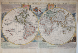
Nice example of De Fer's wall map of the world, first published in 1700. The text notes that the map is a reduction of De Fer's 4 sheet wall map of the world, first issued in 1695. De Fer states that this map is the first map to be prepared based upon the astronomical observations of the Royal Academy of Sciences. In fact, it would appear that different sources entirely have been consulted for California, Japan and Australia.
Australia is shown as substantially incomplete and still attached to new Guinea. New Zealand appears in partial outline. The conjectural land bridge from Asia to America is still in evidence. The Mississippi River has its confluence with the Gulf of Mexico considerably west of its true course, based upon La Salle's eroneous reports. There are many more place names on this 2 sheet edition of the wall map. The scientific comentary is quite remarkable and detailed.
Engraved by Van Loon, the map includes vignettes show thunder, lightening, tempests and tides, volcanoes, etc.
Celestial observations are shown at the top.
Etching with fine original colour, good condition. Rare.
|
Shirley, The Mapping of the World, n. 600.
|
Nicolas DE FER (1646-1720 circa)
|
One of the most prolific and influential French geographers and cartographers of the late 17th and early 18th Century. Nicolas was the youngest son of Parisian print and mapseller, Antoine de Fer [d.1673]. He produced numerous atlases: Atlas Curieux [1700-5] and its subsequent suites; Atlas ou Receuil des Cartes [1709]; Atlas Royale [1699]; Les Beautés de la France [1708]; Atlases detailing wars and countries relating to the Spanish succession [1701]; Italy [1702] & Germany [1705] and Franco-Belgian frontiers [1708-10]; Les Forces de L'Europe [1690-95]; Introduction à la Géographie [1708]; the Petit Nouveau Atlas [1697]. Aswell as his Atlas output de Fer is also well known for his large Wall maps, some 26 in total, aswell as large-scale town plans of European cities, and a signifcant output of thematic printed card games. His sign and emblem was the Sphère Royale, originally that of Melchior Tavernier, to which he was greatly attached and which appears on a large number of his works. He died on 25th October 1720 and his estate was divided between his three daughters, all three of whose husbands were closely involved in the Parisian engraving and publishing business : Guillaume Danet, Remi Richer, Jaques-Francois Besnard or Bénard. A number of de Fer's maps and atlases continued to be published by his heirs for another twenty or thirty years.
|
|
Shirley, The Mapping of the World, n. 600.
|
Nicolas DE FER (1646-1720 circa)
|
One of the most prolific and influential French geographers and cartographers of the late 17th and early 18th Century. Nicolas was the youngest son of Parisian print and mapseller, Antoine de Fer [d.1673]. He produced numerous atlases: Atlas Curieux [1700-5] and its subsequent suites; Atlas ou Receuil des Cartes [1709]; Atlas Royale [1699]; Les Beautés de la France [1708]; Atlases detailing wars and countries relating to the Spanish succession [1701]; Italy [1702] & Germany [1705] and Franco-Belgian frontiers [1708-10]; Les Forces de L'Europe [1690-95]; Introduction à la Géographie [1708]; the Petit Nouveau Atlas [1697]. Aswell as his Atlas output de Fer is also well known for his large Wall maps, some 26 in total, aswell as large-scale town plans of European cities, and a signifcant output of thematic printed card games. His sign and emblem was the Sphère Royale, originally that of Melchior Tavernier, to which he was greatly attached and which appears on a large number of his works. He died on 25th October 1720 and his estate was divided between his three daughters, all three of whose husbands were closely involved in the Parisian engraving and publishing business : Guillaume Danet, Remi Richer, Jaques-Francois Besnard or Bénard. A number of de Fer's maps and atlases continued to be published by his heirs for another twenty or thirty years.
|