
| Reference: | s30849 |
| Author | Jacques Nicolas BELLIN |
| Year: | 1757 |
| Zone: | The World |
| Printed: | L'Aja |
| Measures: | 680 x 495 mm |
| Reference: | s30849 |
| Author | Jacques Nicolas BELLIN |
| Year: | 1757 |
| Zone: | The World |
| Printed: | L'Aja |
| Measures: | 680 x 495 mm |
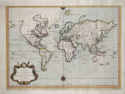
A beautiful example of Bellin's world map on Mercator's projection.
Engraved by J.Van Schley and published in the Hague with English, French and Dutch titles, the map accurately reflects the knowledge of the time - pre-Cook Australasia and the Pacific Northwest remain uncharted, with Japan mapped in a rudimentary way.
North America displays the mythical River of the West potentially linking the Pacific to the Great Lakes.
From Prevost's Histoire Generale des Voyage, The Hague, Pierre de Hondt, 1757.
Bellin was one of the most important cartographers of the 18th century; he was born in Paris, and was a member of the Académie de Marine and the Royal Society of London. In 1721, at the age of 18, he was appointed hydrographer (chief cartographer) to the French Navy. In August 1741, he became the first Ingénieur de la Marine of the Depot des cartes et plans et de la Marine (the French hydrographic office) and was appointed hydrographic officer to the King of France. During his service he was commissioned to survey first the French coastline and later those of the entire known world. His output was immense, and his high-quality nautical charts appeared in multiple editions beyond the end of the 18th century.
Copperplate with fine later hand colour, in good conditions.
Jacques Nicolas BELLIN (1703 - 1772)
|
Jacques-Nicolas Bellin (1703 - 1772) was one of the most important cartographers of the 18th century.
With a career spanning some 50 years, Bellin is best understood as transitional mapmaker spanning the gap
between 18th and early 19th century cartographic styles. His long career as Hydrographer and Ingénieur
Hydrographe at the French Dépôt des cartes et plans de la Marine resulted in hundreds of high quality
nautical charts of practically everywhere in the world. Bellin's work focuses on function and accuracy
tending in the process to be less decorative than the earlier 17th and 18th century cartographic work. In
addition to numerous maps and charts published during his lifetime, many of Bellin's maps were updated
(or not) and published posthumously. He was succeeded as Ingénieur Hydrographe by his student, also a prolific and influential cartographer, Rigobert Bonne.
|