
| Reference: | S299450 |
| Author | Johannes van DOETECUM |
| Year: | 1605 ca. |
| Zone: | The World |
| Printed: | Antwerpen |
| Measures: | 540 x 330 mm |
| Reference: | S299450 |
| Author | Johannes van DOETECUM |
| Year: | 1605 ca. |
| Zone: | The World |
| Printed: | Antwerpen |
| Measures: | 540 x 330 mm |
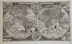
Striking dark impression of this finely engraved double hemisphere map of the World, engraved by Jan Van Doetecum for Paulus Merula in 1605.
Van Doetcum's fine engraving his based upon a map engraved by his father Baptista van Doetecum for Petrus Plancius in 1590, with several important updates, including the addition of the recently explored Nova Zemlya (explored by Barentsz during his 3 voyages to the arctic regions in search of the Northeast Passage) and the addition of two celestial hemispheres, based upon Plancius' world map of 1594. The map also adds fine large format images of 4 islands, Japan, Island, Ceylon and St. Helena, presenting fine enlargements of these islands as they appearon the map.
The map includes the four large islands in the Arctic, as they appeared on Mercator's maps, including his very rare 1595 map of the Polar Regions. The Northwest Passage is open and clearly defined, allowing a passage via the Straits of Anian in the Pacific to the Atlantic. California and Quivira are named, along with annotations on the discovery of America by Columbus in 1492 and notes on the known and unknown northern regions of America.
The massive southern continent is called Magellanica, Terra Australis, and also Terra del Fuego, pre-dating the voyage of Le Maire and Schouten which would begin to re-write the then prevailing belief that the strait discovered by Ferdinand Magellan was the only water passage from between the Atlantic and Pacific Ocean in the Southern Hemisphere. A massive Nova Guinea is shown, with no signs of the modern discoveries in Australia and New Zealand, with remnants of the information from Marco Polo still present in the region (Beach).
There is an early appearance of the Philippines (I. Filipinae). The Chinese coastline, while filled with information, pre-dates the appearance of Korea and provides a very curious presentation of Japan.
The map is richly embellished with strapwork decorations and sailing ships, reflecting the master-engraver's hand characteristic of the Van Doetcum family, which were then perhaps the finest engravers actively engaged in commercial map making.
Etching with engraving, very good condition.
|
R. W. Shirley, "The Mapping of the world", 254; New Hollstein, Doetecum IV, 995
|
Johannes van DOETECUM (Attivo tra il 1554 - 1606)
|
Doetecum was a family of engravers and map publishers working in Deventer and Haarlem (from 1587). Johannes the elder, engraved for C. Plantin and Officina Plantiniana, 1559 onwards. With brother Lucas, worked on De Jode's Nova Totius Terrarum Orbis Descriptio, 1571; Gerard de Jode's Speculum, 1578; Abraham Ortelius and Jan Huyghen van Linschoten.
|
|
R. W. Shirley, "The Mapping of the world", 254; New Hollstein, Doetecum IV, 995
|
Johannes van DOETECUM (Attivo tra il 1554 - 1606)
|
Doetecum was a family of engravers and map publishers working in Deventer and Haarlem (from 1587). Johannes the elder, engraved for C. Plantin and Officina Plantiniana, 1559 onwards. With brother Lucas, worked on De Jode's Nova Totius Terrarum Orbis Descriptio, 1571; Gerard de Jode's Speculum, 1578; Abraham Ortelius and Jan Huyghen van Linschoten.
|