| Reference: | mms2448 |
| Author | Johann ZAHN |
| Year: | 1696 |
| Zone: | The World |
| Printed: | Nurnberg |
| Measures: | 420 x 350 mm |
| Reference: | mms2448 |
| Author | Johann ZAHN |
| Year: | 1696 |
| Zone: | The World |
| Printed: | Nurnberg |
| Measures: | 420 x 350 mm |
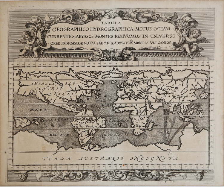
A world chart from the Specula physico-mathematico-historica notabilium ac mirabilium sciendorum, in qua mundi mirabilis oeconomia ... nunc autem ad lucem protractus, ac ad varias perfacili methodo acquirendas scientias in epitomen collectus thesaurus curiosis omnibus cosmosophis inspectandus proponitur... / authore Joanne Zahn, a finely illustrated cosmography, designed to show the ocean currents, vortexes and volcanos.
Johann Zahn (1631-1707), a German monk, also published a … read morebook on optics, 'Oculus Artificialis Teledioptricus Sive Telescopium' (1685), with extensive descriptions of both the camera obscura and the magic lantern, which he used for anatomical lectures.[«] SHIRLEY: World 583, "engravings of a high standard".
The Mundi Mirabilis oeconomia was influenced by Kircher’s Mundus Subterraneus (1665).
The Jesuit scholar, Athanasius Kircher, was one of the first compilers of semi-scientific knowledge about the physical features of the world. This map expounds on Kircher's theories by noting the abysses and the currents they create as well as the locations of the world's known volcanoes. Between the Mediterranean Sea, the Black Sea, the Caspian Sea, and the Persian Gulf, Kircher theorized massive tunnels and a complex interchange of water flows. These tunnels are noted most particularly between the Black and Caspian Sea and between the Mediterranean and the Persian Gulf. Antarctica is shown along the southern part of the map.
In the North a great open northwest passage is depicted running all the way across the map. Shows New Guinea and a suggestion of Australia attached to the 'Australsis Incognita' mainland. Africa is shown with considerably greater accuracy than many maps drawn hundreds of years later – particularly with regard to Niger and Nile River Systems. North America and South America are both wildly malformed, indicating a relatively sketchy knowledge of the continent. Korea is shown as an Island and Japan appears as only a single island.
Copperplate, very good condition.
|
R. W. Shirley, "The Mapping of the world", 583.
|
|
Johann Zahn, a German monk, also published a … read morebook on optics, 'Oculus Artificialis Teledioptricus Sive Telescopium' (1685), with extensive descriptions of both the camera obscura and the magic lantern, which he used for anatomical lectures. He published 'Mundi Mirabilis Oeconomia..', a finely-illustrated cosmography, designed to show the ocean currents, vortexes and volcanos.
|
|
R. W. Shirley, "The Mapping of the world", 583.
|
|
Johann Zahn, a German monk, also published a … read morebook on optics, 'Oculus Artificialis Teledioptricus Sive Telescopium' (1685), with extensive descriptions of both the camera obscura and the magic lantern, which he used for anatomical lectures. He published 'Mundi Mirabilis Oeconomia..', a finely-illustrated cosmography, designed to show the ocean currents, vortexes and volcanos.
|