| Reference: | s14001 |
| Author | Giuseppe MOLINI |
| Year: | 1807 |
| Zone: | The World |
| Printed: | Florence |
| Measures: | 650 x 340 mm |
| Reference: | s14001 |
| Author | Giuseppe MOLINI |
| Year: | 1807 |
| Zone: | The World |
| Printed: | Florence |
| Measures: | 650 x 340 mm |
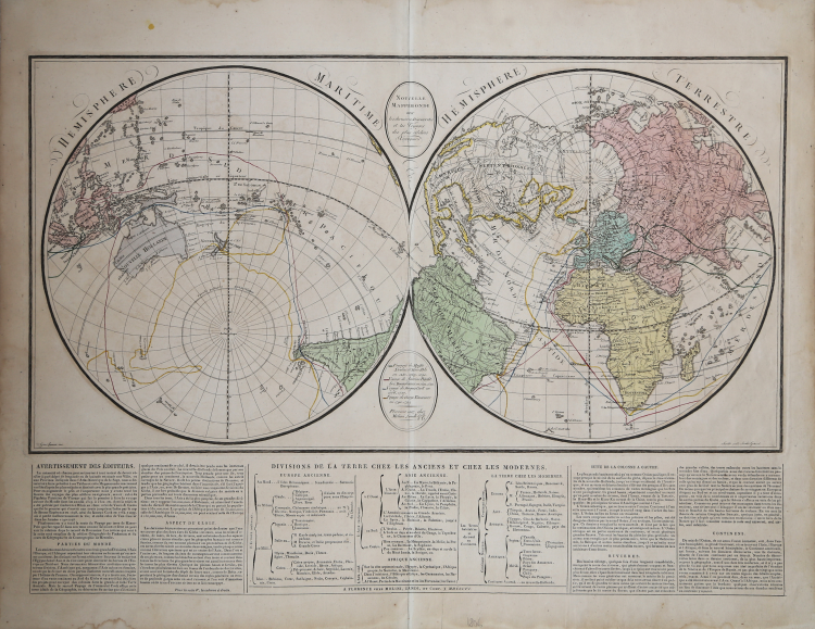
Map taken from Atlas historique, chronologique, geographique et genealogique.
This very rare world map shows two hemispheres and displays the travel routes of the Polo Family (1230-1295), the explorers Magellan and Pigafetta (1519-1522), James Cook (1776-1780) and George Vancouver (1790-1795) in colored lines.
The mythical "Sea of the West" is shows in detail in the northwest of the continent. It also shows a very clearly delineated Northwest Passage.
The map was published by Giuseppe Molini, who was active in Florence in early 19th centery. He teamed with Landi to publish several maps and atlases, most of them copied from works of other French cartographers including Brue and Le Sage.
Giuseppe MOLINI (Attivo a Firenze inizio '800)
|
Giuseppe Molini is the publisher and dealer of cartography in Florence until 1850. Together with Landi publishes several maps and atlases, mainly derived from the French cartographers, who Brue, Le Sage and others.
|
Giuseppe MOLINI (Attivo a Firenze inizio '800)
|
Giuseppe Molini is the publisher and dealer of cartography in Florence until 1850. Together with Landi publishes several maps and atlases, mainly derived from the French cartographers, who Brue, Le Sage and others.
|