
| Reference: | S42271 |
| Author | Jan Evertsz CLOPPENBURGH |
| Year: | 1630 ca. |
| Zone: | The World |
| Printed: | Amsterdam |
| Measures: | 280 x 210 mm |
| Reference: | S42271 |
| Author | Jan Evertsz CLOPPENBURGH |
| Year: | 1630 ca. |
| Zone: | The World |
| Printed: | Amsterdam |
| Measures: | 280 x 210 mm |
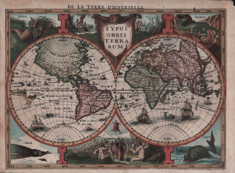
Medium-size map of the world from the French Cloppenburg edition of the Atlas Minor made by Jodocus Hondius. A reduced version of his legendary 1624 folio size map of the world, which was the first map to show any of the Dutch discoveries of Australia.
The two hemispheres are surrounded by allegoric representations of the four elements, a popular motif in Dutch graphic art. It expresses the need of mankind to establish order in the world. Dating back to ancient Greek science and philosophy, the four classical elements were considered to form the structure of the universe. A relation was assumed between the four elements and the seasons. Spring corresponded to Air, Summer to Fire, Autumn to Earth and Winter to Water. Center top are the Temptation and the Expulsion of Adam and Eve from the Garden of Eden. Center bottom is the Last Judgement. Together the decorations depict a cosmic order in which everything is related in one global harmony.
"This map is part of the French Cloppenburg edition of the "Atlas Minor" of 1630. While in the other editions of this atlas the idea of a great unknown south-land traversing both hemispheres is retained, the French and Latin edition show a quite different picture of the world. The unknown southern continent has disappeared altogether and south of Java the west-coast of Java emerges, here named T lant van Eendracht." (Schilder).
In this edition of the map, the western coast of Australia makes a very early appearance and is named T'lant van Eendracht. This is a very early depiction of a portion of the Australian continent, based upon the name of the ship which made the first landfall on the western Australian coast in 1616. 'Eendracht' meaning harmony or concord is found on other maps as an early name for the continent. The earliest such appearances of this information came only 2 years earlier and this is one of only a small group of maps to include the information. Also in the Eastern Hemisphere, the Nile in Africa originates from twin lakes south of the equator, and Korea appears as a very skinny peninsula. America features numerous mountain ranges and large rivers with no Great Lakes, while South America is depicted with the two mythical lakes Lacus Parime in Guiana and Lacus Epana in Brazil.
The edition of Mercator's Atlas published by Jan Evertsz. Cloppenburg was a competitive edition. Its newly engraved maps were of a size (c. 19 x 25 cm) that fell in between the folio maps in the Mercator-Hondius Atlas (c. 35 x 50 cm) and the Atlas Minor (c. 15 x 20 cm). Most of the maps were engraved (anew) by Pieter van den Keere.
Cloppenburg's Atlas is dedicated to the States General of the United Provinces and Prince Frederik Hendrik of Orange (1584-1647), stadhouder of Holland etc. The Cloppenburg edition was continued for a couple of years but seems to have been suppressed after 1636. It was continued after 1673 by the Janssonius heirs.
Copper engraving with fine later hand colour, very good condition.
Bibliografia
Shirley, R.W. (World) 334; Schilder, G. (Australia) #33.
Jan Evertsz CLOPPENBURGH(attivo ad Amsterdam pimi decenni del XVII secolo)
Jan Evertsz CLOPPENBURGH(attivo ad Amsterdam pimi decenni del XVII secolo)