| Reference: | S39546 |
| Author | Reiner & Joshua OTTENS |
| Year: | 1707 ca. |
| Zone: | West Africa |
| Printed: | Amsterdam |
| Measures: | 580 x 490 mm |
| Reference: | S39546 |
| Author | Reiner & Joshua OTTENS |
| Year: | 1707 ca. |
| Zone: | West Africa |
| Printed: | Amsterdam |
| Measures: | 580 x 490 mm |
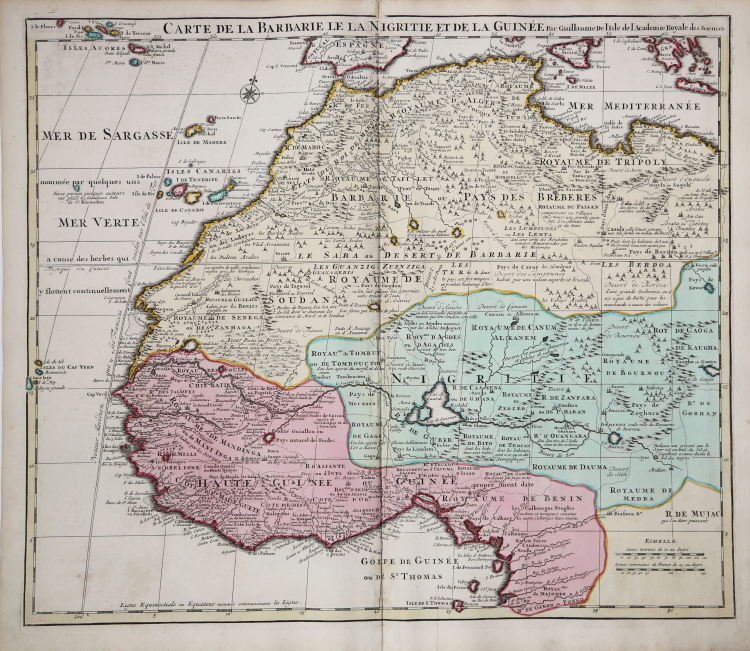
Detailed map of Northwestern Africa, published by Guillaume De L'Isle, the French Royal Mapmaker.
Published in Amsterdam by Reiner & Joshua Ottens nel 1745 circa.
Extends from the Kingdom of Tripoli and the Mediterranean to the Gulf of Guinea and the Gabon River, with remarkable detail throughout. Includes the Canary Islands, Madeira and the Cape Verdes.
One of the most detailed and scientifically accurate maps of the region published at the beginning of the 18th Century.
Guillaume de l'Isle (1675-1726) was the son and pupil of the cartographer Jean Dominique Cassini, who, among other important contributions, aligned the study of astronomy to the study of geography. Under Cassini's direction, observations were made from locations all over the world that enabled longitudinal calculations to be made with much greater accuracy.
De l'Isle carried on this exacting work with remarkable dedication and integrity, constantly revising and improving his maps. While precision was his primary goal, his maps are invariably elegant and attractive. Jean (Johannes) Covens and Corneille (Cornelius) Mortier were brothers-in-law, who carried on the book publishing business established by Pierre Mortier in Amsterdam in 1685.
Pierre Mortier's company owed much of its success to his access to French publishers, whose publications he re-issued in handsome editions. The elder Mortier died in 1711; his wife continued the firm until she died in 1719. In 1721, Covens and Mortier formed a partnership, Covens having married Agatha Mortier in the same year. They continued the business by publishing enlarged editions of Sanson, Jaillot, and De L'Isle, as well as some of the later Dutch cartographical masters such as De Wit and Allard, and of course Pierre Mortier.
This map is from an edition of De L'Isle entitled, Atlas Nouveau, Contenant Toutes Les Parties Du Monde, Ou sont exactement Remarquées les Empires, Monarchies, Royaumes, Etats, Republiques &c. Par Guillaume de l'Isle. Premier Géographe de sa Majesté. It delineates the island in great detail.
At the time the map was made, the coastal areas were ruled by the Dutch East Indian Company, who were undoubtedly responsible for the soundings indicated around the island and for mapping the roads depicted. Copper engraving, contemporary colour, in perfect condition.
|
Cf Norwich, O.I. Norwich's maps of Africa (2nd ed.), map 317 (1700-1712 ed.)
|
|
The family business of print and map selling was founded by Joachim Ottens but the active period of map publishing was concentrated in the years between 1720 and 1750 when the brothers, Reiner and Joshua, produced enormous collections of maps, some as large as 15 volumes.
These, including copies of practically all maps available at the time, were made up to order and were magnificently coloured. Besides these specially prepared collections they also issued single-volume atlases with varying contents as well as pocket atlases.
|
|
Cf Norwich, O.I. Norwich's maps of Africa (2nd ed.), map 317 (1700-1712 ed.)
|
|
The family business of print and map selling was founded by Joachim Ottens but the active period of map publishing was concentrated in the years between 1720 and 1750 when the brothers, Reiner and Joshua, produced enormous collections of maps, some as large as 15 volumes.
These, including copies of practically all maps available at the time, were made up to order and were magnificently coloured. Besides these specially prepared collections they also issued single-volume atlases with varying contents as well as pocket atlases.
|