| Reference: | s34939 |
| Author | Henrick SCHERER |
| Year: | 1702 ca. |
| Zone: | Canary Islands & Azores & Cape Verde Islands |
| Printed: | Munich |
| Measures: | 355 x 238 mm |
| Reference: | s34939 |
| Author | Henrick SCHERER |
| Year: | 1702 ca. |
| Zone: | Canary Islands & Azores & Cape Verde Islands |
| Printed: | Munich |
| Measures: | 355 x 238 mm |
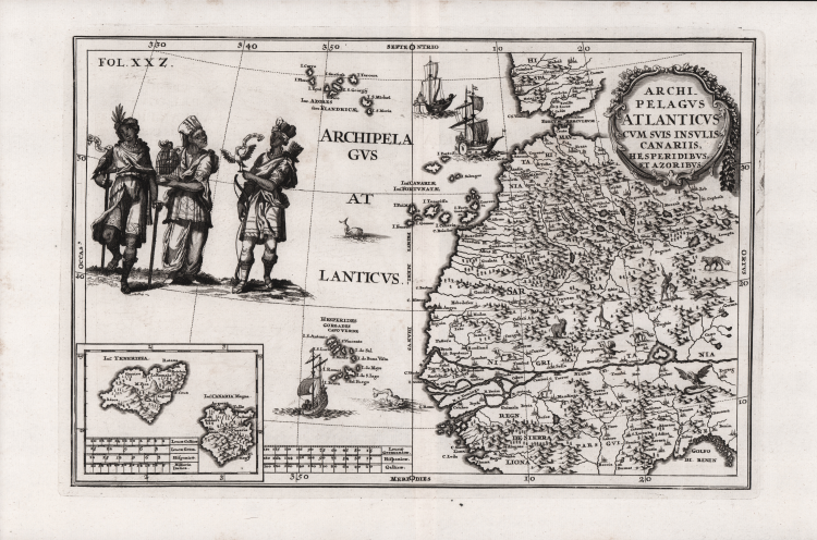
Striking map depicting the northwestern portion of the continent, extending to southern Spain and the Strait of Gibraltar. By Heinrich Scherer (1628-1704) for his Atlas Novus exhibens orbem terraguem per naturae opera, historiae navae acveterus monumenta, artistique geographicae leges et praecepta...published in eight volumes from 1702-1710 in Munich.
Scherer, a devout Jesuit, produced this geographical compendium to depict the Catholic hierarchy and the spread of Jesuit missions throughout the world.
The interior is fully engraved with depictions of mountains, forests, rivers, cities, and a number of animals, including lions, giraffes, and elephants. The Azores, Canary Islands and Cape Verde Islands are well depicted, and an inset of Tenerira and Canary appears at bottom left.
The map is richly ornamented with a decorative title cartouche, ships, sea monsters, and three large native figures holding three birds native to the region: an accipter, a canary and a flamingo.
|
Shirley (BL Atlases) T.SHER-1a #158.
|
Henrick SCHERER (Dilingen 1628 - Monaco 1704)
|
Heinrich Scherer was a devout Jesuit, and professor of mathematics at Munich. His 'Atlas Novus' contained maps of all other parts which showed the spread of Catholicism and Jesuit missions.
|
|
Shirley (BL Atlases) T.SHER-1a #158.
|
Henrick SCHERER (Dilingen 1628 - Monaco 1704)
|
Heinrich Scherer was a devout Jesuit, and professor of mathematics at Munich. His 'Atlas Novus' contained maps of all other parts which showed the spread of Catholicism and Jesuit missions.
|