| Reference: | MS6014 |
| Author | Giovanni Antonio MAGINI |
| Year: | 1597 ca. |
| Zone: | Rovigo |
| Printed: | Bologna |
| Measures: | 480 x 340 mm |
| Reference: | MS6014 |
| Author | Giovanni Antonio MAGINI |
| Year: | 1597 ca. |
| Zone: | Rovigo |
| Printed: | Bologna |
| Measures: | 480 x 340 mm |
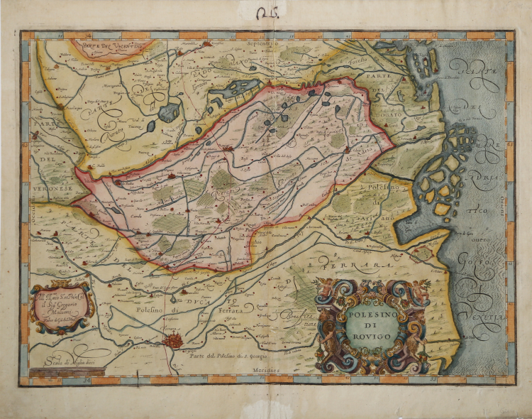
Map taken from L'Italia edited by Fabio Magini, published in Bologna in 1620, three years after the untimely death of his father.
Composed of a short descriptive text of only 24 pages, the work is accompanied by 61 maps of the peninsula, and is the first example of an Italian atlas. The work is entirely by the hand of Giovanni Antonio Magini, who began the realization of the maps in 1594 or so; the first dated map (1595) the map of the territory of Bologna. All the maps were printed before 1620, in their provisional drafts, later corrected and updated for the final edition. For the realization of the plates Magini used two of the most famous engravers of the time: the Belgian Arnoldo Arnoldi and the English Benjamin Wright.
Original old colour. The somewhat naîve colour indicates the borders of the areas. The map shows the Polesine which is the name of the low ground between the lower courses of the rivers Adige and Po and the sea. The derivation of the name is much discussed, generally applied only to the province of Rovigo, but is sometimes extended to the neighborhood of Adria and Ferrara, as on this map.
In basso, nel cartiglio a destra, il titolo POLESINO DI ROVIGO; a sinistra la scala grafica Scala di Miglia dieci (10 miglia pari a mm 70). Orientazione nei quattro lati al centro con il nome dei punti cardinali Septentrio, Meridies, Oriens, Occidens, il nord in alto. Graduazione ai margini di 1’ in 1’ da 44° 31’ a 45° 12’ 40’’ di latitudine, e da 33° 49’ 40’’ a 35° 12’ di longitudine. In basso a destra aggiunto un cartiglio con la dedica All’ Ill.mo mio S.r et P[at]ron[us] Col.o il Sig.r Gregorio Malvezzi. segue l’imprint editoriale Fabio di Gi[ov]a[nni] Ant.o Magini.
La mappa mostra il territorio del Polesine, compreso tra i corsi dei fiumi Adige e Po e il mare. La derivazione del nome "Polesine" è molto discussa, generalmente applicato alla sola provincia di Rovigo, ma talvolta è esteso ai territori di Adria e Ferrara, come su questa mappa.
Come osserva Almagià, la datazione e le fonti di questa carta maginiana, rappresentano una questione abbastanza complessa. Sembra certo che il Magini attinga informazioni da Giovanni Bonifacio, come desunto da diverse lettere di questi inviate al cartografo padovano. In particolare l'opera sarebbe una fusione tra la mappa del territorio Trevigiano del Rover/Bonifacio del 1591 (Bifolco-Ronca tav. 53) e la carta del Polesine del 1602 (Bifolco-Ronca tav. 57) che il Bonifacio inviò al Magini, come risulta da una lettera del 28 gennaio 1603.
Esemplare di secondo stato, con la dedica al Malvezzi firmata da Fabio Magini contenuta nel cartiglio in basso a destra. Finemente colorata a mano.
Bibliografia
Almagià, L'Italia di Giovanni Antonio Magini, pp. 44-5, n. 10.
Giovanni Antonio MAGINI (1555 - 1617)
|
Giovanni Antonio Magini was born in Padua in 1555, dedicating himself to the study of astronomy from an early age. In 1588 the Senate of Bologna appointed him Lecturer of Astronomy at the local University, choosing him instead of Galileo Galilei. His friendship with the Duke of Mantua, Vincenzo Gonzaga, helped Magini in his quest to obtain cartographical material for map-making from the various sovereigns ruling the different Italian states at that time. Because of Magini's early death in 1617, this effort was made famous by his son Fabio when he published the atlas "L'Italia" in Bologna in 1620. This is the first example of an Italian atlas and is made up of 24 pages of descriptive text and 61 maps of the Italian peninsula. Although this work was published posthumously, it can be entirely ascribed to Magini. He began drawing this maps around 1594, with the one depicting Bologna and its surrounding territories being the first. They were all printed before 1620 in draft editions which were then revised and updated for the final version. These draft proofs are extremely rare, although sometimes available for sale, and exhibit substantial differences in respect to the maps finally included in the atlas. Two of the most famous engravers of the time, Arnoldo Arnoldi and the englishman Benjamin Wright, were entrusted by Magini to engrave the plates. As we shall see in the presentation of the separate maps, they derive from different sources, both known and unknown, and therefore represent the result of an original work of critical analysis and compilation. This atlas had an important influence on the cartography of the italian peninsula for the following two centuries, beginning from Ortelius and going on to the principal dutch cartographers and editors.
|