
| Reference: | S43353 |
| Author | Antonio ZATTA |
| Year: | 1778 |
| Zone: | Bermudas |
| Printed: | Venice |
| Measures: | 445 x 340 mm |
| Reference: | S43353 |
| Author | Antonio ZATTA |
| Year: | 1778 |
| Zone: | Bermudas |
| Printed: | Venice |
| Measures: | 445 x 340 mm |
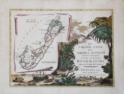
The title-sheet of a twelve-sheet map of the United States, with Bermuda shown on a trompe-l'oeil scroll.
Bermuda has an interesting cartographic error. The first authoritative map of Bermuda was compiled by Norwood in 1622 and published by John Speed in 1627. Behind the main map Norwood superimposed the coastline of New England and Virginia to show the relative position of Bermuda. Although Zatta has dropped this mainland from his map he has retained the small Bermuda, mistaking it for another island in the chain. This confirms that Zatta's source for this map was over a century old.
Map from the Atlante novissimo, illustrato ed accresciuto sulle osservazioni e scoperte fatte dai più celebri e più recenti geografi. Printed in four volumes by Antonio Zatta between 1779 and 1785.
Atlas among the most beautiful and complete ever published in Italy in the eighteenth century, the most famous work of Zatta.
The Atlante Novissimo, as also specified in the title, is “increased on the observations made by the most famous and most recent geographers”. Among the most significant innovations there is the appearance of the new islands discovered in the Pacific Ocean by James Cook and the first Italian map of New Zealand. The illustrations were designed and drawn by his collaborators Giovanni Marco Pitteri, Anton Friedrich Busching, Pietro Antonio Novelli and engraved by Giuliano Zuliani.
The first volume of the atlas is introduced by a brief essay of general geography where the author defines in a concise and precise way the elements that make up the ecliptic and equatorial grids used in the tables. Interesting is the section where he pauses to describe the phenomenon of precession of the equinoxes and the cyclical variation of the obliquity of the ecliptic.
Etching, printed on contemporary laid paper, contemporary outline coloring, in good condition.
Bibliografia
PALMER: Printed maps of Bermuda, p.26, plate xxxi.
Antonio ZATTA (Venezia 1722 - 1804)
|
Antonio Zatta (1775-1797) was the most prominent Italian map publisher of the late 18th and early 19th century. His firm, based in Venice, produced maps that mark an important transition from 18th to 19th century cartographic styles. He updates and redefines the traditional title cartouche by replacing the mythic elements common to the 17th and 18th century with more representative images of Venice. His most important work is the four volume Atlante novissimo published from 1775 to 1789.
|