
| Reference: | S9583 |
| Author | Jodocus HONDIUS Jr. |
| Year: | 1627 |
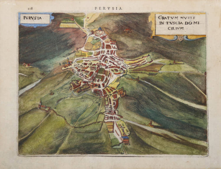
| Zone: | Perugia |
| Printed: | Leyden |
| Measures: | 232 x 175 mm |
| Reference: | S9583 |
| Author | Jodocus HONDIUS Jr. |
| Year: | 1627 |
| Zone: | Perugia |
| Printed: | Leyden |
| Measures: | 232 x 175 mm |
Plate taken from Nova et accurata Italiae hodiernae descriptio in qua omnium eius regionum, vrbium, pagorum, dominiorum, castellorum, montium, fluviorum, fontium, lacuum, et portuum, historia exhibetur. Geographicis tabulis et vrbium praecipuarum iconibus illustrata a Iudoco Hondio addita est Siciliae, Sardiniae, Corsicae, et itinerariorum per Italiam brevis delineatio, printed in Leiden by the printing house Elzevir in 1627.
This is a geographical atlas combined with a town book, exclusively dedicated to Italy. The work consists of 31 maps and 67 views or plans of cities. The maps derive from Mercator's Atlas Minor, while the plans are based on the models introduced in Venice by Francesco Valegio and those of Civitates Orbis Terrarum by G. Braun and F. Hogenberg. The work is related to the period in which Jodocus Hondius II had just separated from his brother Hendrick. According to the literature there is a first edition of the collection, printed in Amsterdam in 1626.
Copper engraving, finely hand-colored, in excellent condition.
Literature
Cremonini, pp. 23/25, n. 18; Fossati Bellani; n. 320. Willems; n. 279.
Jodocus HONDIUS Jr. (Amsterdam 1594 -1629)
|
Jodocus Hondius Jr. was born in 1593, and his earliest signed publication was a map of Scandinavia, issued in 1613. Son of Jodocus Hondius (1563-1612) - engraver, cartographer, printer and publisher – founder of the Hondius typography, that was one of the most important of the time, even thanks to the collection of Mercator’s plates and the pubblication of many charts and atlases. In 1604, Hondius bought the copperplates of Mercator’s Atlas at the auction of Gerard Jr.’s effects. He added another forty maps, including new maps of the Continents and important regional maps of the Americas, before publishing a new edition of the Atlas, in 1606, in competition with Ortelius’ Theatrum. As many of the maps were more up-to-date, the Mercator-Hondius Atlas effectively superseded Ortelius’ Theatrum. On his death in 1612 his widow, Coletta van den Keere continued the business with his two childs; Jodocus Jr. and Hendrick (1597-1651) took over. In June 1621, Jodocus Jr. married Anne Staffmaecker, and moved into a shop on the Dam, where he established his own publishing business. From the period 1621 onwards, Jodocus Jr. published a small number of maps, including several "figured border" maps, including maps of the four continents, the British Isles and Brabant. In 1618 Jodocus Jr. published the important map "Nova Virginiae Tabula", engraved by Dirk Grijp, being the first and most important derivative of John Smith's map of Virginia originally published in 1612. (Burden, America, 193). Other engravers who worked for Hondius are Abraham Goos, Salomon Rogiers, Evert Sijmonsz van Hamersveldt. Very little is known about the cooperation between the Hondius' brothers and their brother-in-law. Aside from the partnership in the continuation of Jodocus Sr's workshop (1612), it seems all three successively started their own businnes. However, from the map of Orange of 1627, it appears that a cooperation certainly extended as far as that year, as the map has a dedication by Jud. et Henr. Hondius to Frederick Henry. According to Peter van the Krogt (cf. Atlantes Neerlandici) Jodocus Hondius Jr. and his younger brother Henricus Hondius where competitors.
|