
| Reference: | CO-383 |
| Author | Ferrando BERTELLI |
| Year: | 1563 |
| Zone: | Tuscia |
| Printed: | Venice |
| Measures: | 445 x 320 mm |
| Reference: | CO-383 |
| Author | Ferrando BERTELLI |
| Year: | 1563 |
| Zone: | Tuscia |
| Printed: | Venice |
| Measures: | 445 x 320 mm |
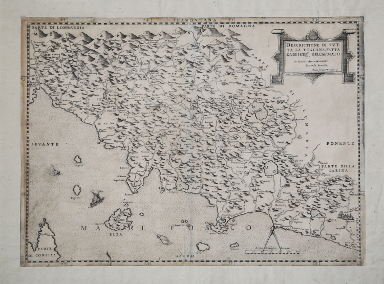
At upper right, in a cartouche with ornate borders, the title and editorial details: DESCRITTIONE DI TUTTA LA TOSCANA FATTA DA M[esser]. HIER:mo BELL’ARMATO. In Venetia Anno MDLXIII. Ferando Bertelli. Paulo Forlani Veronese f. In At lower right, highlighted by a compass, is represented the Scale de miglia Italiani (30 miles = mm 69). Orientation in the four sides in the center with the names of the winds: TRAMONTANA, OSTRO, PONENTE, LEVANTE, north is at the top. Graduation in the margins of 1' in 1', from 41°23' to 43° 26' latitude and 2' in 2', from 32° 32' to 36° 28' longitude.
Rare plate published in Venice in 1563 by Ferrando Bertelli and engraved by Paolo Forlani from Verona. As the cartouche itself suggests, this is yet another derivation of Girolamo Bellarmato's 1536 Chorographia Tusciae, of which it retains the slightly trapezoidal shape.
“La Chorographia Tusciae di Girolamo Bellarmato (o Bellarmati) rappresenta il prototipo della cartografia a stampa della regione. Di forma leggermente trapezoidale, è composta da quattro fogli uniti. Sebbene priva di scala grafica, dal valore dei gradi di latitudine possiamo ricostruire il valore della riduzione, pari a 1:325.000 circa. Nella lunga dedica a Valerio Orsini, generale dell’esercito dei Medici, l’autore specifica che la carta è utile per la professione sua presentandola perciò quale strumento ad uso militare, politico e amministrativo. Questo prodotto cartografico si basa su dati ricavati da una sistematica osservazione diretta, da misurazioni e rilievi effettuati dall’autore sul territorio. Viene data attenzione a tutti gli aspetti geografici; per i centri abitati la grandezza della raffigurazione è rapportata all’entità della popolazione. Molto curata l’idrografia, ben evidenziata l’orografia che è disegnata con dei coni, di maggiori dimensioni per i rilievi più importanti. Questo pregevole ed innovativo lavoro fu preso a modello per molti anni a seguire ed ebbe numerose derivazioni. Come osserva Biasutti (1908), anche Gastaldi utilizzò il rilievo del Bellarmato per comporre la sua carta della penisola (1561). L’opera costituisce altresì la base per le carte della regione che i fiamminghi Abraham Ortelius (1570) e Gerard Mercator (1587) inseriscono nei rispettivi atlanti. Della carta è oggi noto un solo esemplare, conservato all’Archivio di Stato di Firenze” (cfr. Cartografia e Topografia Italiana del XVI secolo p. 1961).
Etching and engraving, 1563, signed in plate in cartouche at upper right. Example from the first state of four. Beautiful proof, impressed on contemporary laid paper, trimmed at the platemark and with contemporary margins added, in good condition.
Bibliografia
S. Bifolco – F. Ronca, Cartografia e Topografia Italiana del XVI secolo pp. 1978/79, tav. 995 I/IV; Almagià (1929): p. 20; Bifolco-Ronca (2014): n. 88; Lago (1994): p. 267, fig. 28; Karrow (1993): n. 10/1.6; Lago (2002): p. 427, fig. 419; Mostra Bergamo (2016): n. 57; Pellegrini (2002): pp. 105-107, tav. III; Tooley (1939): nn. 574, 577; Woodward (1990): n. 25; Woodward (1992): n. 23.
Ferrando BERTELLI (attivo a Venezia seconda metà del XVI secolo)
|
Bertelli family represents the largest group of publishers, engravers, cartographers and merchants of prints of the sixteenth century. Ferrando Bertelli was the most productive, active between 1570, the 1560th, but maps of the last quarter of the century are known by the names of Andrea, Donato, Lucca, Nicholas and Peter. This was mainly active in Padua, where he led a workshop in letterpress and engravings. The earliest records show the asset at the date of 1589 as an engraver of several plates for an edition entitled Diversarum nationum habitus which was published in collaboration with Alciato Alciati. Pietro Bertelli had a library in Padua "the banner of the Angel". At his death the business was inherited by his son Francis. Bertelli was wandering engraver, copperplate engraver and publisher, print dealer active in Venice between 1561 and 1572. We do not have the precise biographical Bertelli.
He teamed with Camocio and the Forlani for the edition and trade cards and plants, they should also become the core business of spreading in the city by Italian and foreign ones, increasing the development of cartography. As a publisher chalcographer emerged from his workshop papers invention of Giacomo Gastaldi, Pirro Ligorio etc.. Although numerous papers of Drawings of the most illustrious cities and fortresses in the world (Venice 1568) bear his signature. Of 1572 is his last edition, the famous islands, harbors, fortresses … Sig.ria subject to Venice, a collection of 88 maps and charts, loose and perhaps already published some of them attributable to the engraving by Martin Rota Sibenik . Later, Ferrando mapss were reprinted by Donato Bertelli (by which we can not determine whether there were family ties) and Donato Rascicotti. Bibliography: Valerio, Cartographers Veneti, p. 149.
|