
| Reference: | S40082 |
| Author | Mathias Albrecht LOTTER |
| Year: | 1790 ca. |
| Zone: | Black Sea, Ukraine & Russia |
| Printed: | Ausburg |
| Measures: | 630 x 435 mm |
| Reference: | S40082 |
| Author | Mathias Albrecht LOTTER |
| Year: | 1790 ca. |
| Zone: | Black Sea, Ukraine & Russia |
| Printed: | Ausburg |
| Measures: | 630 x 435 mm |
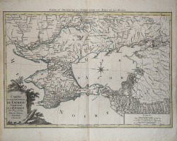
This rare map depicts the theater of war during the Russo-Turkish War that began in 1787, shortly before the publication of the map.
At the end of the previous Russo-Turkish War, Russia had annexed the Crimean Khanate, but the Ottomans sought to regain the territory. The Ottomans failed in their attempt, and the war ended with the Treaty of Jassy in 1792 with Russia maintaining control over the region surrounding the Sea of Azov, as shown here. The map gives great detail of the rivers, roads, towns and topography of the land.
The map is embellished with a compass rose and a title cartouche on a stone plinth surrounded by vegetation.
Copperplate with original outline colour, in very good condition. Rare.
Mathias Albrecht LOTTER (Augusta, 1741 – 1810)
|
Matthias Albrecht Lotter was the son of Tobias Conrad Lotter (1717 - 1777) a German engraver and map publisher. The elder Lotter was the son of a baker and city guardsman, and married Euphrosina (1709-1784) Seutter, elder daughter of the prominent map publisher Matthäus Seutter.
|