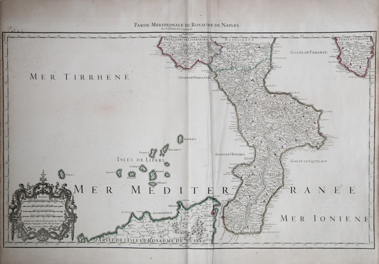
| Reference: | CO-544 |
| Author | Alexis Hubert JAILLOT |
| Year: | 1781 |
| Zone: | Calabria |
| Measures: | 735 x 440 mm |
| Reference: | CO-544 |
| Author | Alexis Hubert JAILLOT |
| Year: | 1781 |
| Zone: | Calabria |
| Measures: | 735 x 440 mm |
Foglio inferiore della magnifica carta del Regno di Napoli del 1703/06 di Hubert Jaillot; raffigura la Calabria e le coste settentionali della Sicilia. Jaillot, insieme al resto della cartografia, sembra seguire in larga misura il modello stabilito da Magini quasi un secolo prima; la sua rappresentazione delle isole Tremiti suggerisce che la sua fonte diretta - come per molte delle mappe di Jaillot - fosse una carta dell'Italia prodotta da Nicolas Sanson. La presente carta, tuttavia, è incisa su una scala più grande e presenta dettagli superiori a quelli di qualsiasi prodotto del Sanson..
Esemplare stampato nel 1781 da Dezauche.
Il foglio settentrionale di questa carta fu inciso da Jaillot nel 1703 (gli esemplari non uniti recano questa data nel margine inferiore del foglio superiore). La parte inferiore, che reca la data nel cartiglio della scala, fu completata nel 1706. Entrambe le mappe furono aggiunte all'Atlas François di Jaillot, che nonostante la datazione del 1695 contiene tipicamente numerose mappe aggiunte successivamente. La mappa sarà ristampata più volte da Covens e Mortier alla metà del XVIII secolo e ancora da Dezauche nel 1781.
Alexis Hubert Jaillot, nacque verso il 1632 ad Avignon-lès-Saint-Claude. Dall’infanzia Jaillot aveva mostrato un buon talento per l’arte e il disegno e da suo fratello Pierre-Simón aveva imparato la scultura. Durante il conflitto franco-spagnolo la loro città natale fu devastata, e così i due fratelli si trasferirono a Parigi nel 1657. Lì acquisirono presto una certa reputazione e il titolo di “Sculpteur du Roy”. Nel 1665, Jaillot si sposò con Jeanne Berey, figlia di Nicolas I Berey. La fortuna di Jaillot fu di entrare nel mercato cartografico in un momento particolarmente favorevole. All’inizio del 1668, sotto Luigi XIV, per la Francia iniziò un periodo particolarmente fecondo, come conseguenza della costante espansione territoriale c’era una grande richiesta di mappe che rappresentassero le conquiste francesi e le nuove frontiere.
In seguito, Jaillot si associò con i figli di Nicolas Sanson, e fu in grado di commercializzare nuove carte con il prestigioso nome Sanson. Il suo atlante del 1681, l’Atlas Nouveau, divenne un tale successo commerciale che fu copiato illegalmente da altri editori. Jaillot non può essere annoverato tra i cartografi dell’epoca come i Sanson e Duval, fu però un abile incisore che seppe intelligentemente sfruttare le risorse che aveva ereditato, facendone opere mirabili. La sua fama crebbe al punto che il 20 luglio 1686 fu nominato “Géographe du Roy” e gli fu assegnata una cospicua pensione annuale; il titolo gli consentì di difendersi dai numerosi contraffattori. Una delle sue opere più belle fu Le Neptune François, o Atlas Nouveau des Cartes Marine. Dall’inizio del diciottesimo secolo la sua produzione di carte diminuì: erano richieste mappe sempre più aggiornate che non era in grado di offrire. D’altronde, i concorrenti più giovani erano geografi del calibro di Guillaume Delisle. Jaillot (m. 1712) cedette, quindi, l’azienda a suo figlio Bernard Jean-Hyacinthe.
Incisione in rame, coloritura coeva dei contorni, piega di carta verticale, per il resto in ottimo stato di conservazione.
Alexis Hubert JAILLOT (1632 - 1712)
|
Alexis Hubert Jaillot (c. 1632- 1712) followed Nicholas Sanson (1600 - 1667) and his descendants in ushering in the great age of French Cartography in the late 17th and 18th century. The publishing center of the cartographic world gradually transitioned from Amsterdam to Paris following the disastrous inferno that destroyed the preeminent Blaeu firm in 1672. Hubert Jaillot was born in Franche-Comte and trained as a sculptor. When he married the daughter of the enlumineur de ala Reine, Nicholas Berey, he found himself positioned to inherit a lucrative map and print publishing firm. When Nicholas Sanson, the premier French cartographer of the day, died Jaillot negotiated with his heirs to republish much of Sanson's work. Though not a cartographer himself, Jaillot's access to the Sanson plates enabled him to publish numerous maps and atlases with only slight modifications and updates to the originals. As a sculptor and an artist, Jaillot's maps were particularly admired for their elaborate and meaningful allegorical title cartouches and other decorative elements. Jaillot used his allegorical cartouche work to extol the virtues of the Sun King Louis IV, and his military and political triumphs. These earned him the patronage of the French crown who used his maps in the tutoring of the young Dauphin. In 1686 he was awarded the title of Geographe du Roi< and with it significant prestige and the coveted yearly stipend of 600 Livres. Jaillot was one of the last French map makers to acquire this title. Louis XV, after taking the throne, replaced the position with the more prestigious and singular title of Premier Geographe du Roi. Jaillot died in Paris in 1712. His most important work was his 1693 Le Neptune Francois Jalliot was succeed by his son, Bernard Jean Hyacinthe Jaillot (1673-1739), grandson, Bernard Antoine Jaillot (???? – 1749) and the latter's brother-in-law, Jean Baptiste-Michel Renou de Chauvigné-Jaillot (1710-1780).
|