| Reference: | S43537 |
| Author | Tomas LOPEZ y Vargas Machuca |
| Year: | 1792 |
| Zone: | Spain |
| Printed: | Madrid |
| Measures: | 1020 x 840 mm |
| Reference: | S43537 |
| Author | Tomas LOPEZ y Vargas Machuca |
| Year: | 1792 |
| Zone: | Spain |
| Printed: | Madrid |
| Measures: | 1020 x 840 mm |
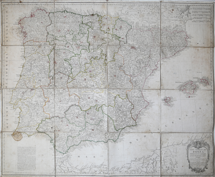
Mapa general de España, dividido en sus actuales provincias, islas adyacentes, y reyno de Portugal: compuesto con lo mejor que hay impreso, manuscrito, noticias de sus naturales, y sujeto a las observaciones Astronómicas por Tomás López, Geógrafo de los Dominios de S.M. con Real Decreto de la Academia de San Fernando individuo de mérito, del número de la História, Honorario de las Buenas letras de Sevilla, y de las sociedades Vascongadas y Asturias.
Large four-sheet map of the Iberian Peninsula signed by renowned Spanish cartographer Tomas López de Vargas Machuca.
Made during the reign of Charles IV (1788-1808), it includes the Iberian Peninsula, the Balearic Islands and the coast of North Africa. Later updated, it became part of the Atlas Geográfico de España, a collection of 102 maps, made by Tomás López and published in 1804, 1810, 1830 and 1844 by the author's sons, who died in 1802.
This rare map was formed with information from the same author's provincial maps and Vicente Tofiño's coastal and island data. The meridians and parallels are drawn in a grid. Meridian origin of the summit of Teide, island of Tenerife (Canary Islands).
In the upper right corner are graphic scales in leagues of 20 in a degree, geographic of Spain, legal of Castilian, common of Portugal and common of France. In the lower right corner is the main decorated cartouche; a cornucopia, which has four crowns, two above and two below, symbolizing the king's domains; inside are the title, author, place and date of printing. On the left side is a brief explanation of the information contained in the map and thanks to Tofiño and Minister Valdés, as well as a description of some regions of Spain. The relief is represented by descending mountain profiles, showing the main mountain systems. Planimetry with representation of cities and division of kingdoms and provinces. Hydrography represents the main network with the names of the most important rivers. Coastline is highlighted with horizontal lines. Abundant toponymy.
Tomás López de Vargas Machuca (1730-1802) was a Spanish cartographer active in the later part of the 18th century. Vargas was born in Toledo and studied mathematics, grammar, and rhetoric at the Colegio Imperial in Madrid. In 1752, with the patronage of the Marquis de la Ensenada, he relocated to Paris where he studied cartography under the legendary French mapmaker Jean Baptiste Bourguignon d'Anville (1697 – 1782). On his return to Spain, King Carolos III, appointed him Geógrafo de los Dominios de Su Magestad and gave him charge over the newly created Gabinete de Geografía. In this position, he dedicated the remainder of his life to a detailed mapping of Spain, producing numerous important regional maps. He was a member of the Real Academia de San Fernando, the Real Sociedad Bascongada de Amigos del País and the Academia de Bellas Letras de Sevilla. López was succeeded by his two sons, also cartographers, who published several atlases based upon his work.
Copperplate engraving, printed on 4 sheets of contemporary laid paper, sectioned into as many 4 parts and applied to canvas, folded several times to case. Some oxidation and water marks, canvas lined on verso, overall in good condition. Rare.
Tomas LOPEZ y Vargas Machuca (1731-1802)
|
Tomás López de Vargas Machuca (1730-1802) was a Spanish cartographer active in the later part of the 18th century. Vargas was born in Toledo and studied mathematics, grammar, and rhetoric at the Colegio Imperial in Madrid. In 1752, with the patronage of the Marquis de la Ensenada, he relocated to Paris where he studied cartography under the legendary French mapmaker Jean Baptiste Bourguignon d'Anville (1697 – 1782). On his return to Spain, King Carolos III, appointed him Geógrafo de los Dominios de Su Magestad and gave him charge over the newly created Gabinete de Geografía. In this position, he dedicated the remainder of his life to a detailed mapping of Spain, producing numerous important regional maps. He was a member of the Real Academia de San Fernando, the Real Sociedad Bascongada de Amigos del País and the Academia de Bellas Letras de Sevilla. López was succeeded by his two sons, also cartographers, who published several atlases based upon his work.
|