
| Reference: | S39885 |
| Author | Vincenzo CORONELLI |
| Year: | 1690 ca. |
| Zone: | Southern America |
| Printed: | Venice |
| Measures: | 890 x 610 mm |
| Reference: | S39885 |
| Author | Vincenzo CORONELLI |
| Year: | 1690 ca. |
| Zone: | Southern America |
| Printed: | Venice |
| Measures: | 890 x 610 mm |
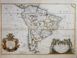
Striking example of Coronelli's spectacular 2 sheet map of South America, one of the most influential maps of South America published in the late 17th Century.
Splendid large ornate cartouche with Coronelli's normal flourish. The map illustrates many of the primitive notions of the new world then prevalent in the European thought and can be seen as an effort to make a statement and as subtle propaganda to it user of the day. It shows many highly specific views f the continent with savages appearing to be harming other through many cruel and barbaric means including warfarce and torturing. All of the natives are depicted as aggressive savages, consistent with the thought prevalent at the time. The map depicts real and imagined places, rivers, mountains, as well as strange and wonderful animals including ones with many heads.
Coronelli's map of South America, appeared in his Atlante Veneto. The map is cartographically similar to the details in South America present in Coronelli's famous globe of 1688 and richly embellished with a style unique to Coronelli's maps.
Copperplate, with fine later hand colour, very good condition.
Example taken form Coronelli’s Atlante Veneto, Nel quale si contiene la Descrittione Geografica, Storica, Sacra, Profana e Politica degli Imperi, Regni, Provincie, e Santi dell’Universo […] In Venetia MDCXC.
Coronelli lived a period of extraordinary editorial fecundity starting from 1689, when he had the chair of geography at the University at the Procuratie, with the publication, in 1690, of the first volume of the Atlante Veneto. Under the name of Atlante Veneto goes the entire collection of thirteen works composed over the next decade, from the Isolario to the Specchio del mare.
The work was intended as an extension of Blaeu’s Atlas Maior. It is no mere collection of maps, but rather “a compendium of geographical, cosmographical, and scientific information... on contemporary Italian science and geography” (Scammell). As well as maps, the first volume includes several of Coronelli’s celebrated naval plates, many with the separately-printed “Farnese” borders especially commissioned by Coronelli’s patron, Ranuccio II Farnese, Duke of Parma.
Copperplate, with full margins, very good condition. Very rare.
Literature
Ermanno Armao, Vincenzo Coronelli (Florence, 1944), no.59, no.60 and p.237.
Vincenzo CORONELLI (Venezia 1650 - 1718)
|
Cosmographer, geographer, biographer, encyclopedist, globe maker, inventor, expert of engeneering and hydraulics. Extraordinarily versatile mind and an extremely tireless man, he produced more than 140 pieces in different genres. At the age of 15, he entered the Franciscan Order, which he then guided as Gran Generale from 1699. He became famous as geographer and mathematician, awakening the interest in these subjects in Italy at the end of the XVII century. He travelled a lot, seeking for all that was new, and keeping a correspondance with the most important intellectuals of his time. In 1681 Louis XIV wanted him to go to France, to entrust him with the task of making two terraqueous globes (Marly Globes), with a diameter of 4 metres. Once he came back to Italy, in 1685, he became Cosmographer of the Venetian Republic, where he taught geography and founded the first geographic accademy, called The Argonauts Accademy. In his whole life he produced more that 500 maps; some of them can be found in his most famous works, such as the Venetian Atlas (1690), the Island Book of the Venetian Atlas (1696-97), the Book of Globes (1693). As far as his scientific method, he didn’t elaborate new cartographic systems, but followed the theories that were considered most popular and effective at his time, based on the Copernican system. The main characteristic of his charts is the high quantity of toponymic and historical information. In his most famous and dense work, the Venetian Atlas, we can find about 1100 plates, 200 of which are extremely technical and this is the reason why it is considered the first Italian atlas to describe and illustrate the whole world with charts and maps. It was published in 13 volumes, starting from 1690, and it took nearly ten years to finish it. It is divided in different parts, the most important are the Atlas itself, then the Island Book, the Corso Geografico and the Teatro delle città.
|