
| Reference: | S4512 |
| Author | Jaques BELLY detto "Gallus" |
| Year: | 1757 ca. |
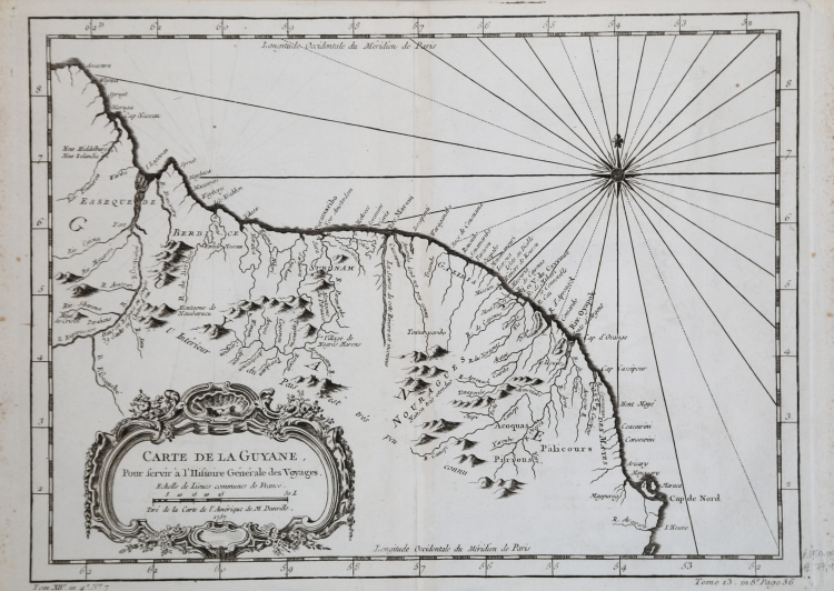
| Zone: | Guyaune |
| Printed: | Paris |
| Measures: | 330 x 245 mm |
| Reference: | S4512 |
| Author | Jaques BELLY detto "Gallus" |
| Year: | 1757 ca. |
| Zone: | Guyaune |
| Printed: | Paris |
| Measures: | 330 x 245 mm |
Map drawn by Jacques Nicolas Bellin, published as a plate of the French edition of 1757 of "Histoire General des Voyages, ou nouvelle collection de toutes les relations de voyages par mer et par terre s" by Antoine François Prévost, better known under the name of abbé Prévost.
The collection, in several volumes, is printed for the first time A Paris: chez Didot, 1746-1753.
The complete work - in 12th - will continue the publications until it reaches, in 1789, a consistency of 80 volumes.
A colossal encyclopedic research work carried out by the author, which also deserves credit for having published numerous unpublished stories about the discovery of Australia by the Dutch and reports of journeys across the Pacific, including those of Magellan and Schouten.
The work is accompanied by nearly 300 illustrations of populations, views, and costumes from around the world and by 113 splendid maps, by Jaques-Nicolas Bellin.
Copperplate in good conditions.
Jaques BELLY detto "Gallus" (Chartres 1609 - 1674)
|
Etcher, born in Chartres, pupil of Vouet. Worked in Rome, and only known from a set of 30 plates (plus frontispiece) after Annibale Carracci's Farnese ceiling published in 1641.
|
Jaques BELLY detto "Gallus" (Chartres 1609 - 1674)
|
Etcher, born in Chartres, pupil of Vouet. Worked in Rome, and only known from a set of 30 plates (plus frontispiece) after Annibale Carracci's Farnese ceiling published in 1641.
|