| Reference: | s34944 |
| Author | Henrick SCHERER |
| Year: | 1699 |
| Zone: | Southern America |
| Printed: | Munich |
| Measures: | 362 x 235 mm |
| Reference: | s34944 |
| Author | Henrick SCHERER |
| Year: | 1699 |
| Zone: | Southern America |
| Printed: | Munich |
| Measures: | 362 x 235 mm |
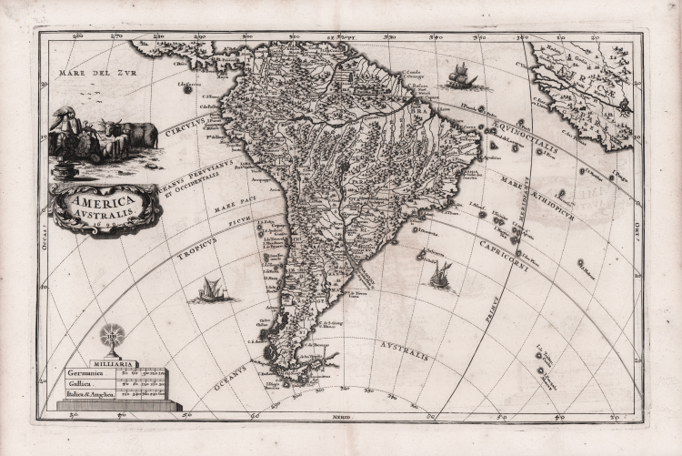
Decorative map of South America by Heinrich Scherer for his Atlas Novus exhibens orbem terraguem per naturae opera, historiae navae acveterus monumenta, artistique geographicae leges et praecepta...published in eight volumes from 1702-1710 in Munich. Scherer, a devout Jesuit, produced this geographical compendium to depict the Catholic hierarchy and the spread of Jesuit missions throughout the world.
The map is filled with towns and pictorial representations of the mountainous topography.
Near Guyana, the fictitious lake of Parime is named with the mythical city of Dorado shown upon its shores. A number of ships sail the seas, and the map is decorated with a cartouche showing the bounty of South America, including fat-tailed sheep.
The scale of miles is topped with the symbol for the Society of Jesus.
Copper engraving, in very good condition.
|
Shirley (BL Atlases) T.SHER-1a #114.
|
Henrick SCHERER (Dilingen 1628 - Monaco 1704)
|
Heinrich Scherer was a devout Jesuit, and professor of mathematics at Munich. His 'Atlas Novus' contained maps of all other parts which showed the spread of Catholicism and Jesuit missions.
|
|
Shirley (BL Atlases) T.SHER-1a #114.
|
Henrick SCHERER (Dilingen 1628 - Monaco 1704)
|
Heinrich Scherer was a devout Jesuit, and professor of mathematics at Munich. His 'Atlas Novus' contained maps of all other parts which showed the spread of Catholicism and Jesuit missions.
|