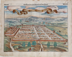
Il Cuscho Citta Principale Della Provincia Del Peru Sebastian Münster Code: S37759 Measures: 420 x 340 mm Year: 1556 ca. Printed: Basle Price €325.00 Quick view View Details
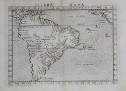
Tierra Nova Girolamo RUSCELLI Code: S11220 Measures: 245 x 185 mm Year: 1561 ca. Printed: Venice Price €500.00 Quick view View Details
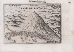
Mynes de Potosi Barent LANGENES Code: S50669 Measures: 125 x 85 mm Year: 1609 Printed: Frankfurt Price €125.00 Quick view View Details
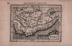
Peru Jodocus HONDIUS Jr. Code: MS2409 Measures: 135 x 90 mm Year: 1616 ca. Printed: Amsterdam Price €130.00 Quick view View Details
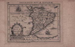
America Meridionalis Jodocus HONDIUS Jr. Code: ms2408 Measures: 135 x 100 mm Year: 1616 ca. Printed: Amsterdam Price €250.00 Quick view View Details
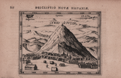
Cerro de Potosi Jodocus HONDIUS Jr. Code: MS2410 Measures: 130 x 110 mm Year: 1616 ca. Printed: Amsterdam Price €150.00 Quick view View Details
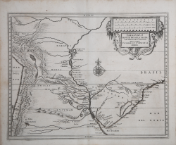
Paraguay ò Prov. de Rio de La Plata: cum adiacentibus Provinciis Johannes de Laet Code: S44865 Measures: 360 x 285 mm Year: 1625 ca. Printed: Leyden Price €600.00 Quick view View Details
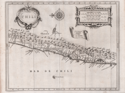
Chili Johannes de Laet Code: S44863 Measures: 360 x 285 mm Year: 1625 ca. Printed: Amsterdam Price €700.00 Quick view View Details
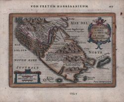
Provinciae Sitae ad Fretum Magallanis itemque Fretum le Maire Johannes de Laet Code: S44864 Measures: 360 x 285 mm Year: 1625 ca. Price €900.00 Quick view View Details
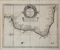
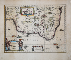
Provincia de Brasil cum Adiacentibus Provinciis Johannes de Laet Code: S44866 Measures: 360 x 285 mm Year: 1625 ca. Price €850.00 Quick view View Details
Freti Magellanici ac novi Freti vulgo Le Maire exactissima delineatio Johannes JANSSONIUS Code: S48210 Measures: 190 x 135 mm Year: 1628 ca. Printed: Amsterdam Price €280.00 Quick view View Details
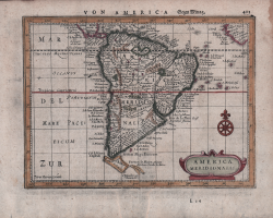
America Meridionalis Johannes JANSSONIUS Code: S48206 Measures: 195 x 145 mm Year: 1628 ca. Printed: Amsterdam Price €250.00 Quick view View Details
Venezuela, cum parte Australi Novae Andalusiae Johannes JANSSONIUS Code: s35019 Measures: 496 x 380 mm Year: 1630 ca. Printed: Amsterdam Price €475.00 Quick view View Details
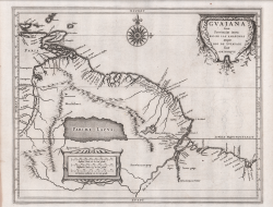
Guaiana sive Provinciae intra Rio de las Amazonas Johannes de Laet Code: S44867 Measures: 360 x 285 mm Year: 1630 ca. Printed: Leyden Price €600.00 Quick view View Details
Venezuela atque Occidentalis Pars Novae Andalusiae Johannes de Laet Code: S44868 Measures: 360 x 285 mm Year: 1630 ca. Printed: Amsterdam Price €650.00 Quick view View Details
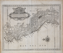
Peru Johannes de Laet Code: S44862 Measures: 360 x 285 mm Year: 1630 ca. Printed: Amsterdam Price €600.00 Quick view View Details
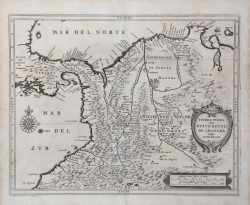
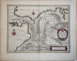
Tierra Firma item Nuevo Reyno de Granada atque Popayan Johannes de Laet Code: S44861 Measures: 360 x 285 mm Year: 1630 ca. Printed: Amsterdam Price €600.00 Quick view View Details
Novus Brasiliae Typus Willem Janszoon BLAEU Code: S37040 Measures: 502 x 380 mm Year: 1633 ca. Printed: Amsterdam Price €800.00 Quick view View Details
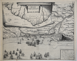
Das Norder theil des Lands Brasilien…. Matthaus MERIAN "il vecchio" Code: MMS2888 Measures: 450 x 370 mm Year: 1633 ca. Printed: Frankfurt Price €775.00 Quick view View Details
Terra Firma et Novum Regnum Granatense et Popayan Willem Janszoon BLAEU Code: S4830 Measures: 485 x 365 mm Year: 1635 Printed: Amsterdam Price €400.00 Quick view View Details