| Reference: | S40159 |
| Author | Johann Baptist HOMANN |
| Year: | 1705 ca. |
| Zone: | Sicilia |
| Printed: | Nurnberg |
| Measures: | 570 x 490 mm |
| Reference: | S40159 |
| Author | Johann Baptist HOMANN |
| Year: | 1705 ca. |
| Zone: | Sicilia |
| Printed: | Nurnberg |
| Measures: | 570 x 490 mm |
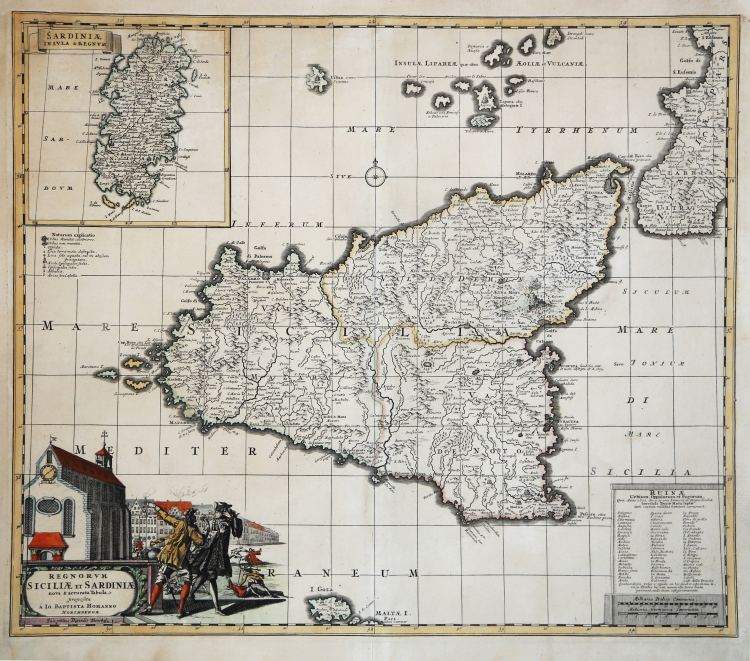
Carta geografica della Sicilia di Johann Baptist Homann, stampata a Norimberga.
La carta, che reca nell'angolo superiore sinistro un cartiglio contenente una piccola carta della Sardegna dal titolo "Sardinia Insula & Regnum", è tratta dal Neur Atlas […] von Johann Baptista Homann Nurnerg In verleguguns des Auctoris".
La carta di Homann è stampata dallo stesso rame che David Funck aveva pubblicato nel 1693 in occasion del terremoto del gennaio dello stesso anno (cfr. Valerio-Spagnolo, p. 368).
Johann Baptist Homann was a German geographer and cartographer; in 1702 he founded his own publishing house. Homann acquired renown as a leading German cartographer, and in 1715 was appointed Imperial Geographer by Emperor Charles VI. In the same year he was also named a member of the Prussian Academy of Sciences in Berlin. In 1716 Homann published his masterpiece Grosser Atlas ueber die ganze Welt; numerous maps were drawn up in cooperation with the engraver Christoph Weigel the Elder. Homann died in Nuremberg in 1724 and was succeeded by his son Johann Christoph (1703-1730). The company carried on upon his death as Homann heirs company, managed by Johann Michael Franz and Johann Georg Ebersberger. After subsequent changes in management the company folded in 1852.
“Il titolo della carta recita: “... nova & accurata Tabula proposita a Io. Baptista Homanno Norimbergae. Sumptibus Davidis Funckij" con chiaro riferimento a David Funck quale editore della carta.
In effetti questa carta utilizza lo stesso rame inciso da Homann nel 1693 per conto di David Funck, che aveva realizzato tale carta per raccontare e ricordare il terribile ter- remoto del gennaio dello stesso anno, riportandone anche i danni subiti dalle comunità locali.
Le variazioni tra i due stati sono notevoli, ma non riguardano l'immagine topografica dell'isola, bensì i due angoli in basso a destra e a sinistra, e l'angolo in alto a sinistra. In basso a destra l'elenco delle città colpite dal terremoto è contornato da una cornice, che ingloba anche le sottostanti scale; in basso a sinistra, invece, scompare la firma dell'incisore Homann insieme alle isole di Pantelleria e di Linosa e, al loro posto, appare un cartiglio figurato con il nuovo titolo. Il significato del cartiglio non è di immediata interpretazione: sono rappresentati alcuni fatti di sangue in prossimità di una chiesa, che reca in facciata la data 1282, posta immediatamente sotto un orologio. La data rimanda senza ombra di dubbio ai Vespri Siciliani, la cui scintilla scoccò proprio davanti a una chiesa, santo Spirito di Palermo, che potrebbe ricordare vagamente quella dell'immagine, seppure in forme più marcatamente nordiche. Il ricordo di quei fatti trova una sua ragione nel particolare momento storico nel quale la mappa viene nuovamente pubblicata da Homann e cioè nella prima fase della guerra di successione spagnola (1701-1713). Con tale mappa, pubblicata a Norimberga, città che sotto l'influenza del nuovo stato Prussiano aveva aderito alla lega antifrancese, si voleva mettere in guardia Luigi XIV dal portare avanti le sue ambizioni sulla Sicilia attraverso la conquista del trono di Spagna, ricordando a lui e ai suoi alleati una vicenda storica particolarmente dolorosa per i francesi, che avrebbe anche potuto ripetersi.
In un riquadro in alto a sinistra, al posto del titolo della precedente edizione ("Infelicis Regni Siciliae") compare una mappa della Sardegna col titolo "Sardiniae Insula & Regnum>> (155x160), al di sotto della quale rimane la vecchia "notarum explicatio", che presenta anche due simboli realtivi ai danni subiti dai centri abitati: un asterisco per "Loca terrae motu destructa" e una piccola croce greca per "Loca solo aequata, vel in abyssum praecipitata".” (Valerio-Spagnolo "Sicilia 1477-1861", p. 366).
Acquaforte, finemente colorata a mano, in ottimo stato di conservazione.
Bibliografia:
Valerio-Spagnolo "Sicilia 1477-1861", pp. 366-368, n. 174.
Johann Baptist HOMANN (1663 - 1724)
|
Johann Baptist Homann (20 March 1664 – 1 July 1724) was a German geographer and cartographer
born in Oberkammlach near Kammlach in the Electorate of Bavaria. Although educated at a Jesuit school, and preparing for an ecclesiastical career, he eventually converted to Protestantism and from 1687 worked as a civil law notary in Nuremberg. He soon turned to engraving and cartography; in 1702 he founded his own publishing house. Homann acquired renown as a leading German cartographer, and in 1715 was appointed Imperial Geographer by Emperor Charles VI. Giving such privileges to individuals was an added right that the Holy Roman Emperor enjoyed. In the same year he was also named a member of the Prussian Academy of Sciences in Berlin. Of particular significance to cartography were the imperial printing privileges (Latin: privilegia impressoria). These protected for a time the authors in all scientific fields such as printers, copper engravers, map makers and publishers. They were also very important as a recommendation for potential customers. In 1716 Homann published his masterpiece Grosser Atlas ueber die ganze Welt (Grand Atlas of all the World). Numerous maps were drawn up in cooperation with the engraver Christoph Weigel the Elder, who also published Siebmachers Wappenbuch. Homann died in Nuremberg in 1724. He was succeeded by his son Johann Christoph (1703-1730). The company carried on upon his death as Homann heirs company, managed by Johann Michael Franz and Johann Georg Ebersberger. After subsequent changes in management the company folded in 1852. The company was known as "Homann Erben", "Homanniani Heredes", or "Heritiers de Homann" abroad.
1702-07 Atlas novus terrarum
1712 Enlarged edition with re-issues to c.1753
c.1714 Neuer Atlas
re-issues to c. 1730
1719 Atlas Methodicus
1730 America Septentrionali Britannorum
1737 Grosser atlas
re-issues to c. 1770
|