| Reference: | S36744 |
| Author | Giacomo CANTELLI |
| Year: | 1682 |
| Zone: | Sicily |
| Printed: | Rome |
| Measures: | 555 x 445 mm |
| Reference: | S36744 |
| Author | Giacomo CANTELLI |
| Year: | 1682 |
| Zone: | Sicily |
| Printed: | Rome |
| Measures: | 555 x 445 mm |
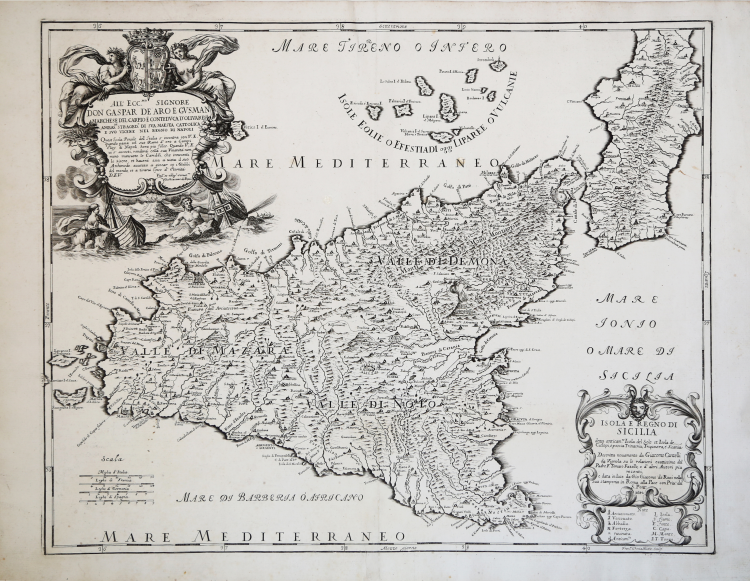
The map provides one of the most detailed and up to date treatments of Sicily and the neighboring islands. Includes several ornate cartouches and a dedication to Signore Don Gaspar De Aro E Gusman.
Map taken from Mercurio geografico overo Guida Geografica in tutte le parti del Mondo conforme le Tavole Geografiche del Sansone Baudran de Cantelli Data in luce con direttione, e cura di Gio. Giacomo de Rossi nella sua stamperia collection of maps published in Rome between 1660 and 1730 by the typography De Rossi - the date of the maps goes from 1669 to 1715 - whose first edition is due to Giovanni Giacomo de Rossi. Over the years the atlas was enriched by an increasing number of maps in subsequent editions edited first by Domenico de Rossi and then by his son Filippo.
The Mercurio Geografico is a collection that brings together works by cartographers such as Michele Antonio Baudrand, Nicolas Sanson, Augustin Lubin, Filippo Titi, Giacomo Ameti, Giovanni Antonio Magini and Innocenzo Mattei, and which includes as its main "corpus" the great production of the geographer Giacomo Cantelli da Vignola. The maps are finely copied and engraved by the major engravers of the time including Falda, Widman, Barbey, Widman, Lhuillier, Donia, Mariotti.
Cantelli was a geographer and cartographer, a native of Montorsello near Vignola; duties his humanistic studies in Bologna, in 1669, he entered the service of Marquis Obizzo da Ferrara there as secretary, then went to Venice and from there to Paris, where he formed relations with the leading French geographers of the time, Du Val, Nicola Sanson and especially Michel Antoine Baudrand, with whom he then remained in constant correspondence. Returning to Bologna, he was for long years secretary to Rinieri Marescotti; but, around 1675 or shortly thereafter, he went, perhaps several times, to Rome, and entered into relations with the famous De Rossi cartographic workshop, which then published most of his maps. By this time his reputation as a cartographer had been established, so much so that he was called upon by both Pope Innocent XI and the Duke of Modena and Reggio Francesco II d'Este, both of whom wanted him as their official cartographer. He chose the court of Francesco II, and in November 1685 he was appointed court geographer. From 1686 to 1689 he executed numerous maps of European countries and territories. He constructed by his own hand a world map and a celestial globe, which remained on display for some time in the atrium of the Biblioteca Estense in Modena. He died in Modena on November 30, 1695. Almost all the maps were included in the Mercurio Geografico, the well-known atlas published in Rome by the De Rossi family. The first edition of the Mercurio Geografico published 19 of his maps, along with others by Sanson and Baudrand. A two-volume second edition came out in 1692, which contained work he had done (88 maps, engraved by Antonio Barbey).
“La carta di Giacomo Cantelli da Vignola (1643-1695) соstituisce un notevole passo in avanti nella definizione geografica dell'isola; sebbene il contorno costiero riprenda il profilo di Sanson-Jaillot, si
nota un notevole incremento toponomastico e una maggiore ricchezza di dettagli interni. Anche l'andamento dei fiumi non sembra essere ripreso da alcuna carta precedente. Il modello di Cantelli verrà adottato da Coronelli e da Cassiano de Silva, nelle cui carte si nota una perdita di toponimi e alcune varianti linguistiche, significative soprattutto nell'opera di de Silva.
Al di sotto del titolo vengono citate alcune delle fonti utilizzate dall'autore, tra le quali l'opera di Tommaso Fazello (1498-1570), il De Rebus Siculis - vecchia ormai di oltre un secolo, ma ancora prodiga di indicazioni cartograficamente inedite e alcuni non meglio identificati "Autori più recenti".
La cura profusa nella realizzazione della carta, sia da parte dell'autore che dell'editore, si nota anche nella dedica al potente Marchese del Carpio (1629-1687), ambasciatore della corte di Spagna a Roma dal 1677 al 1682 e poi viceré a Napoli dal gennaio del 1683; è a quest'ultimo incarico che fa riferimento Giovan Giacomo De Rossi e ciò pone il termine post quem dell'incisione della Sicilia agli ultimi mesi del 1682.
Cantelli è il primo a distaccarsi dal modello maginiano e a elaborare un inedito disegno dell'isola che non ha riscontro in altre opere a stampa, né precedenti né contemporanee. Assolutamente originale è la configurazione della parte occidentale dell'isola e del Golfo di Castellammare, che ha una forma e una posizione nuove rispetto ai precedenti consolidati modelli.
Si tratta di una delle più accurate opere a stampa della Sicilia prima del grande rilevamento di Schmettau.
La prima attività cartografica di Giovan Giacomo de Rossi (1649-1691) "al tempio della Pace" è precedente alla pubblicazione del Mercurio Geografico, ed è attestata da alcune carte murali copiate sugli originali olandesi di Joannes Blaeu. Le carte dei quattro continenti in più fo- gli, con aggiunte di testo e di vedute laterali, furono pubblicate da Giovan Giacomo nel 1666. Appena tre anni dopo ebbe inizio l'incisione delle tavole geografiche per il Mercurio Geografico. Tra il 1669 e la fine del secolo ap- parvero due volumi, con due distinti frontespizi, che raccoglievano oltre 120 tavole. Le carte furono incise in gran parte da Antonio Barbey, attivo soprattutto nell'ultimo decennio del secolo (Piemonte in quattro fogli datato 1691, Italia del 1693, Romagna del 1699) ma vi collaborarono anche alcuni tra i migliori incisori cartografi del tempo: Giovanni L'Huillier, olandese, che aveva lavorato anche per de Witt, Sanson e Duval, Giorgio Widmann, che firma l'America Settentrionale (1677), la Scandinavia (1678) e la Terra Santa (1679), Vincenzo Mariotti, pit- tore di architetture ed incisore allievo di Andrea Pozzo (1642-1709) e il famoso Giovambattista Falda (1648- 1691), autore di una importante pianta murale di Roma in 12 fogli.
Giacomo Cantelli da Vignola (1643-1695), geografo del duca di Modena, che firma le carte come autore, attinge soprattutto all'opera del geografo francese Nicolas Sanson. Consulente dell'opera fu, molto probabilmente, il geografo francese Michele Antonio Baudrand (1633- 1700), di cui si fa menzione nel titolo, che soggiornò a Roma per alcuni anni sul finire del secolo. L'atlante ebbe parecchie successive edizioni curate dagli eredi di Giovan Giacomo de Rossi nel corso del Settecento; famosa è l'edizione curata da Domenico (1647-1720 ca) realizzata con un numero variabile di tavole, forse in funzione delle richieste del committente, circostanza che complica ulteriormente le ricerche sulla dimensione e sulla completezza dell'atlante. Nel catalogo dei rami incisi posseduti da Filippo de Rossi, del 1735, il Mercurio Geografico risulta composto di due tomi con 95 e 90 mappe per un totale di 185; la Sicilia è nel secondo tomo al numero 145. Tutti i rami della casa tipografica - non solo quelli cartografici - furono acquisiti, nel 1738, dal governo pontificio dopo una lunga trattativa con l'ultimo erede, Filippo de Rossi, che aveva manifestato l'intenzione di cedere l'ingente patrimonio di rami incisi. Il 15 febbraio 1738, acquistata l'intera raccolta per 40.000 ducati, fu fondata la Calcografia Camerale Romana per espressa volontà di Clemente XII.
Nulla si sa dell'incisore Francesco Donia, che si firma quasi orgogliosamente "Messinese", noto per la collaborazione ad alcune tavole del Mercurio Geografico datate tra il 1682 al 1691.” (Valerio-Spagnolo "Sicilia 1477-1861", p. 306).
Copperplate, some foxing, otherwise very good condition.
Bibliografia:
cfr. R. Almagià, Studi storici di cartografia napoletana, in “Archivio storico per le province napoletane”, 38 (1913), p. 645; A. Bonazzi, Il Mercurio geografico: il gioco e la differenza, in “Giacomo Cantelli: geografo del Serenissimo”, Bologna, 1995, p. 37-44 e 150-152; Bagrow 268; Phillips I 254-255; Shirley BL I, pp. 868-874; Valerio-Spagnolo "Sicilia 1477-1861", pp. 306-308, n. 134.
Giacomo CANTELLI (Vignola 1643 - 1695)
|
Cantelli was a geographer and cartographer, a native of Montorsello near Vignola; duties his humanistic studies in Bologna, in 1669, he entered the service of Marquis Obizzo da Ferrara there as secretary, then went to Venice and from there to Paris, where he formed relations with the leading French geographers of the time, Du Val, Nicola Sanson and especially Michel Antoine Baudrand, with whom he then remained in constant correspondence. Returning to Bologna, he was for long years secretary to Rinieri Marescotti; but, around 1675 or shortly thereafter, he went, perhaps several times, to Rome, and entered into relations with the famous De Rossi cartographic workshop, which then published most of his maps. By this time his reputation as a cartographer had been established, so much so that he was called upon by both Pope Innocent XI and the Duke of Modena and Reggio Francesco II d'Este, both of whom wanted him as their official cartographer. He chose the court of Francesco II, and in November 1685 he was appointed court geographer. From 1686 to 1689 he executed numerous maps of European countries and territories. He constructed by his own hand a world map and a celestial globe, which remained on display for some time in the atrium of the Biblioteca Estense in Modena. He died in Modena on November 30, 1695. Almost all the maps were included in the Mercurio Geografico, the well-known atlas published in Rome by the De Rossi family. The first edition of the Mercurio Geografico published 19 of his maps, along with others by Sanson and Baudrand. A two-volume second edition came out in 1692, which contained work he had done (88 maps, engraved by Antonio Barbey).
|