
| Reference: | s30616 |
| Author | Robert MORDEN |
| Year: | 1688 |
| Zone: | Sicily |
| Printed: | London |
| Measures: | 130 x 115 mm |
| Reference: | s30616 |
| Author | Robert MORDEN |
| Year: | 1688 |
| Zone: | Sicily |
| Printed: | London |
| Measures: | 130 x 115 mm |
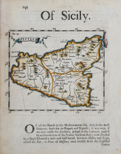
Carta geografica della Sicilia tratta da "Geography Rectified: or a Description of the World..." di Robert Morden.
Questo esemplare proviene dalla terza edizione dell'opera, edita nel 1693.
L'opera, che ebbe ben quattro ristampe dal 1680, anno della prima edizione, al 1700, comprende oltre 70 mappe incise.
“Robert Morden (morto nel 1701) fu un prolifico editore, costruttore di globi e strumenti scientifici, nonché mercante di libri, attivo a Londra nell'ultimo quarto del XVII secolo. La sua prima pubblicazione, del 1669, è relativa all'uso di un quadrante astronomico. Nel 1676 avviò un'attività come stampatore di carte da gioco. Successivamente si dedicò alla pubblicazione di piccoli volumi geografici destinati all'Inghilterra, e altre aree geografiche. Morden è ricordato soprattutto per le carte delle contee inglesi, per la Britannia di William Camden (1695) e per altre importanti produzioni cartografiche, tra le quali la pianta di Londra in 12 fogli di William Morgan, realizzate in associazione con William Berry. Il suo volume Geography Rectified, con oltre 70 piccole mappe, ebbe ben quattro edizioni tra il 1680 e il 1700. Tutte le mappe recano il suo nome ("by Robt. Morden") tranne Francia, Sicilia, Russia e Monomotapa.
I rami subirono alcune modifiche alle coordinate lungo il lato inferiore, con riferimento a Tenerife, e venne aggiunto, nella terza edizione del 1693, il numero di pagina inciso sulla lastra. Patrick Gordon, nella sua Geographical Grammar, riprese alcune delle carte di Morden, ma la Sicilia non risulta tra queste.
Un annuncio relativo a una carta della Sicilia comparve nella London Gazette del 3-7 giugno 1675 (Tyacke 1978: 12): with the Ancient and Modern names of Places, Rivers, Castles, &c. The Highwayes with divers new Observations. Sold by Robert Morden, at the Atlas in Cornhill, and William Berry at the Globe between York-House and the New-Exchange in the Strand.
Sebbene gli editori siano gli stessi coinvolti nella pubblicazione della Geography Rectified, è difficile pensare che quella descrizione si attagli al piccolo rame pubblicato nel 1680. Va rimarcato che non si conoscono altre mappe della Sicilia pubblicate né da Morden né da Berry. Per la diversa impaginazione e le variazioni al rame, si veda l'illuminante esempio del Giappone in Hubbard 2012.” (Valerio-Spagnolo "Sicilia 1477-1861", p. 198).
Incisione su rame, contorni colorati a mano, in ottime condizioni.
Bibliografia:
Valerio-Spagnolo "Sicilia 1477-1861", pp. 298-300, n. 130.
Robert MORDEN (circa 1650-1703)
|
Robert Morden (c.1650-1703) was an English bookseller, publisher, and maker of maps and globes. He was among the first successful commercial map makers.
Between about 1675 and his death in 1703, he was based under the sign of the Atlas at premises in Cornhill and New Cheapside, London. His cartographical output was large and varied. His best-known maps are those of South Wales, North Wales and the English Counties first published in a new edition of Camden's "Britannia" in 1695, and subsequently reissued in 1722, 1753 and 1772. These maps were based on new information from gentlemen of each county, and were newly engraved. Each had a decorated cartouche, and showed numerous place names. Morden also produced in 1701 a series of smaller county maps often known as Miniature Mordens.
In 1695 he published a map of Scotland. It is in parts (e.g. Skye and the Western Isles) essentially a copy of the 1654 map done by Robert Gordon of Straloch, published by Joan Blaeu; other parts show evidence of more accurate cartography.
He published a new map of the Tamil homeland, Coylot Wanees Country, in 17th century Ceylon island.
He is also known for several very rare early maps of the British colonies in North America, which are now among the earliest and most sought after maps for collectors of old American maps. He also produced a series of miniature maps of the world, which appeared in both playing card format and in a series of atlases, including his Atlas Terrestris and Geography Anatomiz'd, beginning in 1687.
|