
| Reference: | S41010 |
| Author | Giovanni Antonio MAGINI |
| Year: | 1608 ca. |
| Zone: | Sicily |
| Printed: | Bologna |
| Measures: | 480 x 380 mm |
| Reference: | S41010 |
| Author | Giovanni Antonio MAGINI |
| Year: | 1608 ca. |
| Zone: | Sicily |
| Printed: | Bologna |
| Measures: | 480 x 380 mm |
Map taken from L'Italia edited by Fabio Magini, published in Bologna in 1620, three years after the untimely death of his father.
Composed of a short descriptive text of only 24 pages, the work is accompanied by 61 maps of the peninsula, and is the first example of an Italian atlas. The work is entirely by the hand of Giovanni Antonio Magini, who began the realization of the maps in 1594 or so; the first dated map (1595) the map of the territory of Bologna. All the maps were printed before 1620, in their provisional drafts, later corrected and updated for the final edition. For the realization of the plates Magini used two of the most famous engravers of the time: the Belgian Arnoldo Arnoldi and the English Benjamin Wright.
Copperplate, some repairs inthe central fold, otherwise in good condition.
La carta della Sicilia di Magini è tra le più recenti dell'opera maginiana. Secondo alcuni scritti dell'archivio del Magini apprendiamo che il 6 febbraio 1604 la carta era una delle 6 che mancavano.
Il disegno gli arrivò forse proprio nel 1604; un grande disegno in 5 fogli inviatogli dai signori Giurati di Messina dalla quale l'incisore Benjamin Wright intaglio la carta dell'isola. Tuttavia tale carta era piuttosto povera di toponimi e scarsa di idrografia e orografia. Il Magini si servì pertanto delle notizie trovate nelle carte di Mercator e quella di Gastaldi per completare l'opera che fu inserita nell'atlante.
Questa carta della Sicilia fu largamente ripresa, con lievi varianti, fino alla nuova carta dell'isola realizzata da Guillaume De L'Isle ai primi del '700.
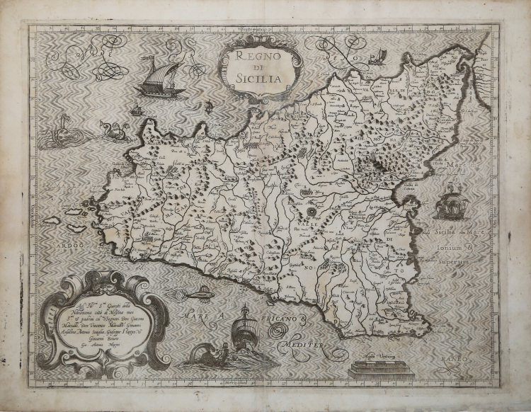
In alto nel cartiglio al centro il titolo REGNO DI SICILIA. In basso a sinistra, nel cartiglio, la dedica Agl’ Ill.mi S.ori Guirati della Nobilissima città di Messina miei S.ori & padroni col.mi i Signori Don Giacomo Marullo, Don Vincenzo Marullo, Giovanni Ansalone, Antonio Suaglia, Giuseppe Stagno, & Giovanni Bruno. Segue la firma Gio: Antonio Magini. Al centro la scala grafica Miglia Vinticinq[ue] (25 miglia pari a mm 47). Orientazione nei quattro lati al centro con il nome dei punti cardinali Septentrio, Meridios, Oriens, Occidens, il nord in alto. Graduazione ai margini di 1’ in 1’ da 35° 16’ a 38° 13’ di latitudine, e da 34° 20’ a 39° 10’ di longitudine.
“La Sicilia, che compare come 61ma e ultima carta della Italia di Giovanni Antonio Magini (1555-1617), doveva servire, nelle intenzioni dell'autore, come una sorta di foglio d'insieme delle carte particolareggiate dei tre Valli dell'Isola, che non furono mai realizzate. Dalla dettagliata e documentata ricostruzione di Almagià sappiamo che la carta della Sicilia non era ancora incisa nel 1604 e solo nel 1605 egli ricevette "dai giurati della città di Messina un disegno della Sicilia in cinque tavole, che prima gli mancava" (1974: XVIII). La carta della Sicilia risulta infine incisa da Benjamin Wright, londinese, insieme alle sei carte che ancora mancavano, nel 1608, per il complemento della Italia.
Tale carta è quella annessa all'edizione definitiva del 1620, nel cui cartiglio dedicatorio si fa riferimento ai "Giurati della Nobilissima città di Messina miei S. (ign)ori e padroni col. (endissi)mi". Malgrado il riferimento ai "Giurati" messinesi, alla fine la carta della Sicilia di Magini risulta essere una copia quasi fedele della carta mercatoriana del 1589 (vedi scheda 54), con il solo spostamento delle coordinate di circa 3' verso sud e 1°05' verso ovest. Per cui, a esempio, le coordinate di Messina da 37°55' e 39°56' in Mercatore, diventano 37°52' e 38°51' in Magini. Tale importante mutazione, che mette in evidenza la significativa rielaborazione maginiana, era sfuggita anche ad Almagià, che pure aveva notato la singolare derivazione mercatoriana, annotando minuziosamente le divergenze (1922: 86, 87) ma non questa.
Cosa molto singolare, le coordinate della carta sono del tutto differenti da quelle pubblicate da Magini nelle sue Ephemerides del 1582 e del 1609.
L'intero atlante di Magini dedicato all'Italia fu letteralmente 'saccheggiato', nel corso del XVII secolo, dagli editori olandesi i quali, attraverso le copie che ne fecero, diffusero il sapere geografico maginiano nell'intera Europa. Le coordinate della mappa della Sicilia fecero 'testo' e furono anch'esse adottate dai maggiori geografi europei. Spesso le carte ritenute di derivazione mercatoriana hanno invece un legame diretto con Magini, piuttosto che con Mercatore.” (cfr. Valerio-Spagnolo "Sicilia 1477-1861", p. 227).
Bibliografia
Dufour-La Gumina (1998): pp. 108, 294; La Gumina (2015): pp. 184-185, n. 66; Valerio-Spagnolo "Sicilia 1477-1861", pp. 227-229, n. 82.
Giovanni Antonio MAGINI (1555 - 1617)
|
Giovanni Antonio Magini was born in Padua in 1555, dedicating himself to the study of astronomy from an early age. In 1588 the Senate of Bologna appointed him Lecturer of Astronomy at the local University, choosing him instead of Galileo Galilei. His friendship with the Duke of Mantua, Vincenzo Gonzaga, helped Magini in his quest to obtain cartographical material for map-making from the various sovereigns ruling the different Italian states at that time. Because of Magini's early death in 1617, this effort was made famous by his son Fabio when he published the atlas "L'Italia" in Bologna in 1620. This is the first example of an Italian atlas and is made up of 24 pages of descriptive text and 61 maps of the Italian peninsula. Although this work was published posthumously, it can be entirely ascribed to Magini. He began drawing this maps around 1594, with the one depicting Bologna and its surrounding territories being the first. They were all printed before 1620 in draft editions which were then revised and updated for the final version. These draft proofs are extremely rare, although sometimes available for sale, and exhibit substantial differences in respect to the maps finally included in the atlas. Two of the most famous engravers of the time, Arnoldo Arnoldi and the englishman Benjamin Wright, were entrusted by Magini to engrave the plates. As we shall see in the presentation of the separate maps, they derive from different sources, both known and unknown, and therefore represent the result of an original work of critical analysis and compilation. This atlas had an important influence on the cartography of the italian peninsula for the following two centuries, beginning from Ortelius and going on to the principal dutch cartographers and editors.
|