| Reference: | S44377 |
| Author | Nicolas VISSCHER I |
| Year: | 1660 ca. |
| Zone: | Sicily |
| Printed: | Amsterdam |
| Measures: | 570 x 475 mm |
| Reference: | S44377 |
| Author | Nicolas VISSCHER I |
| Year: | 1660 ca. |
| Zone: | Sicily |
| Printed: | Amsterdam |
| Measures: | 570 x 475 mm |
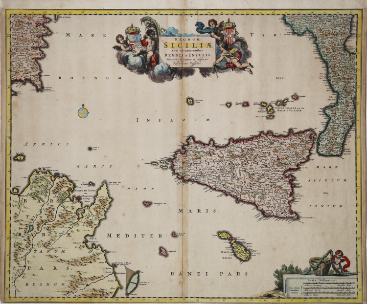
Second state (of three) of Nicolas Visscher's famous map centered on Sicily but including Calabria, the southeastern coast of Sardinia, and the northern coast of Tunisia. The first state of the map bears the title Regnum Sicilia, without the diphthong of Siciliae of this second state; the third state bears an indication of the printing privilege.
The map is published in Visscher's Atlas Contractus Orbis Terrarum.
"Three or four other editions of Atlas Contractus are recorded, edited by Nicolaes Visscher I, and about ten editions of Atlas Minor Sive Geographia Compendiosa, qua Orbis Terrarum per Paucas Attamen Novissimas Tabulas Ostenditur, edited by his son Nicolaes Visscher II. Since these are collections without dates and often also without table indexes, Sicily appears sporadically; I therefore refer to Koeman's descriptions: Vis 6 (1656-77) under the title "Sicilia"; Vis 7 (1664-1677) "Sicilia Regnum"; Vis 12 (1689) "Sicilia Insula"; Vis 18 (1696) "Siciliae Regnum."
The map of Sicily edited by Nicolaes Visscher I (1618- 1679) has a very problematic dating, like almost all the maps edited by the Visschers, due to the lack of dates in the titles and title pages of the atlases, as well as their indexes. The table with the title "Regnum Siciliae" (with the diphthong ae) is recorded in atlases published from 1662 onward to beyond 1690, while the one without the diphthong, does not appear in any repertory. In the alphabetical sequence of the Visschers' maps, Koeman reports at number 233 the only variant with the diphthong ae: evidently the first edition, lacking the privilege, was unknown to him. The engraving of this paper certainly predates 1677, the year in which Nicolaes Visscher was granted the privilege to print his own papers, a privilege that appears instead in the 'with diphthong' edition. Since a copy of the eighth volume of the Geographiae Blauvianae, published in 1662, already includes the map of Sicily with the diphthong, it is very likely that that prior is also earlier than this date, and is included here with this chronological indication.
Nicolaes Visscher I was the son of Claes Jansz. Visscher (1587-1652), a native goldsmith and engraver from Amsterdam who published an atlas in 1634 entitled Germania Inferior, made from copperplates bought from Pieter van den Keere. In 1649 he published another atlas entitled Tabularum Geographicarum Contractarum, containing the same maps as Langenes' Caert-Thresoor. After his father's death, Nicolaes I continued his work, and his first atlas, entitled Atlas Contractus, appeared around 1657. In 1664 he was admitted to the guild of booksellers in Amsterdam and in 1677 was granted a 15-year privilege for the papers he printed (see V. Valerio, in Sicilia 1477-1861, La collezione Spagnolo Patermo, p. 275, n. 114).
Copperplate engraving, contemporary coloring with retouching, traces of glue at central fold, slight oxidation, otherwise in good condition.
Nicolas VISSCHER I (1618 - 1679)
|
For nearly a century the members of the Visscher family were important art dealers and map publishers in Amsterdam. The founder of the business, C. J. Visscher, had premises near to those of Pieter van den Keere and Jodocus Hondius whose pupil he may have been. From about 1620 he designed a number of individual maps, including one of the British Isles, but his first atlas consisted of maps printed from plates bought from van den Keere and issued as they stood with some additions of his own, including historical scenes of battles and sieges for which he had a high reputation. Some maps bear the latinized form of the family name: Piscator. After Visscher's death his son and grandson, both of the same name, issued a considerable number of atlases, constantly revised and brought up to date but most of them lacking an index and with varying contents. The widow of Nicholaes Visscher II carried on the business until it finally passed into the hands of Pieter Schenk.
|