| Reference: | S42716 |
| Author | Henri Abraham CHATELAIN |
| Year: | 1720 |
| Zone: | Knowledge of the Navy |
| Measures: | 595 x 500 mm |
| Reference: | S42716 |
| Author | Henri Abraham CHATELAIN |
| Year: | 1720 |
| Zone: | Knowledge of the Navy |
| Measures: | 595 x 500 mm |
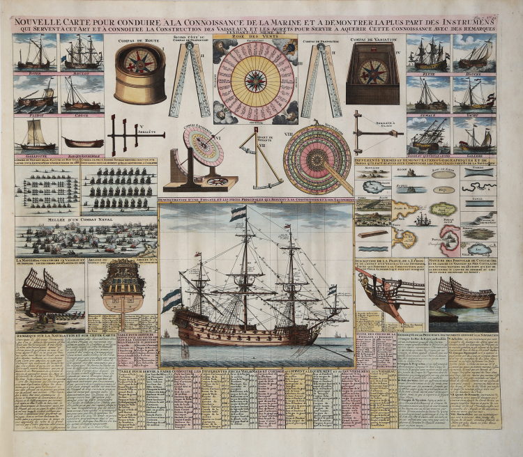
Nouvelle Carte pour Conduire a la connoissance de la Marine et a demontrer la plus part des Instrumens qui servent a cet art et a connaitre la construction des vaisseaux et les aguets pour servir a acquérir cette connaissance avec des remarques tendant au meme but.
This impressive engraving is a wonderful example of Chatelain’s elegant plates. Included in the 1720 edition of Atlas Historique, published by Chatelain in Amsterdam, this large plan shows many different nautical instruments used in navigation, ship types, and ship building. The main ship shown is well described with a numbered key identifying over 100 parts of the ship including rigging and various spars. By combining a wealth of historical and geographical information with delicate engraving and an uncomplicated composition, this elegant engraving is a superb example from the golden age of French mapmaking.
This is a fascinating folio sheet filled with engravings of ships and navigation instruments. At the center is a large view of a frigate showing the rigging in great detail. Other engravings include methods of construction, naval combat, several different types of ships, compasses, sextant, quadrant, volvelle, and a superb wind rose.
Henri Abraham Chatelain (1684 - 1743) was a Huguenot pastor of Parisian origins. He is best known as a Dutch cartographer and more specifically for his cartographic contribution in the seminal seven volume Atlas Historique, published in Amsterdam between 1705 and 1720. Innovative for its time, the Atlas Historique combined fine engraving and artwork with scholarly studies of geography, history, ethnology, heraldry, and cosmography. Some scholarship suggests that the Atlas Historique was not exclusively compiled by Henri Chatelain, as is commonly believed, but rather was a family enterprise involving Henri, his father Zacharie and his brother, also Zacharie.
Copperplate with fine later hand colour, perfect condition.
Henri Abraham CHATELAIN (1684 - 1743)
|
Henri Abraham Chatelain (1684 - 1743) was a Huguenot pastor of Parisian origins. He is best known as a Dutch cartographer and more specifically for his cartographic contribution in the seminal seven volume Atlas Historique, published in Amsterdam between 1705 and 1720. Innovative for its time, the Atlas Historique combined fine engraving and artwork with scholarly studies of geography, history, ethnology, heraldry, and cosmography. Some scholarship suggests that the Atlas Historique was not exclusively compiled by Henri Chatelain, as is commonly believed, but rather was a family enterprise involving Henri, his father Zacharie and his brother, also Zacharie. The Atlas Historique published by Chatelain was part of a major work of its time, an encyclopaedia in seven volumes including geography as one of its main subjectes. The text was by Nicholas Gueudeville and the maps by Chatelain. The Atlas included one of the finest maps of America (4 sheets) surrounded by vignettes and decorative insets.
1705-20 Atlas Historique:Amsterdam (maps by Chatelain based on G.Delisle)
Further issues to 1739
|