| Reference: | MS8158 |
| Author | Johannes JANSSONIUS |
| Year: | 1657 ca. |
| Zone: | Pisa |
| Printed: | Amsterdam |
| Measures: | 421 x 345 mm |
| Reference: | MS8158 |
| Author | Johannes JANSSONIUS |
| Year: | 1657 ca. |
| Zone: | Pisa |
| Printed: | Amsterdam |
| Measures: | 421 x 345 mm |
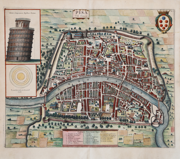
Beautiful map of Pisa by Johannes Janssonius, derivation from the first, famous depiction by Achille Soli printed in the early 17th century by Matteo Florimi.
Example printed by Pieter Vander Aa in 1723, included in the Thesaurus antiquitatum et historiarum Italiae... Lugduni Batavorum, excudit Petrus van der Aa... MDCCXXIII.
First published in the collection of Johannes Janssonius, Theatrum urbium Italiae aliarumque in insulis Maris Mediterraneae, Amsterdam s.d. (c. 1657), vol. V. Janssonius set out to renew the success enjoyed by Braun's Civitates orbis terrarum and succeeded in acquiring the collection of copperplates from the heirs of the last publisher-engraver of the work in Cologne; having eliminated the most deteriorated ones, he added several new ones, resulting in a splendid edition full of plates decorated with cartouches and frames in the Baroque style, motifs dear to the author, who understood the instances of his century and made himself its spokesman. [...] At the end of the century, Frederik de Witt, who already had to his credit editions of maps and atlases, came into possession of the branches published by Janssonius and prepared a new edition entitled Theatrum praecipuarum totius Europae urbium tam icono- graphice quam cospicue delineatarum, Amsterdam s.d. (c. 1680). Finally, the plate comes into the possession of publisher Pieter Vander AA who uses it to illustrate the work of Johan Georg Graevius, Thesaurus antiquitatum et historiarum Italiae, collectus cura et studioJ. G. Graevii, et ad finem perductus a P. Burmanno... Leiden, Peter van der Aa, 1704-1723; the work comprises 9 parts divided into 30 volumes; the map of Pisa appears in volume XXI, illustrating the text by Enrico Noris, Cenotaphia Pisanæ Caii et Lucii Cæsarum dissertationes illustrata.
This is the fourth state; the plate has undergone numerous alterations and retouches. Above, in the center, on the cartouche redrawn in classicist style, the title: Pisa. Urbs Etruriae.; also redrawn is the plaque cartouche of toponyms, with 20 toponymic references all in Latin: to the 17 places indexed in the rubric of the first state, are added the 3 names of gates previously engraved within the plan; modified the upper part of the tower elevation, whose table is now titled: Turris Campanariae Basilicae Pisanae; in the upper right-hand corner is the indication of: Page 1; corrected apex of tower also on plan; deleted the two navicles on the Arno.
"The very close parallelism of survey and representation between this plan of Pisa and the one published by Florimi was resolved by Tolaini by assuming and arguing the derivation of the latter from the former. The skillful but extrinsic remake, unsupported by new sources, while technically perfecting the image inevitably reduces its documentary correspondence and expressive value: descriptive data that are not superfluous are lost; the improbability of urban areas and building structures (Piazza dei Cavalieri, the ar
"The very close parallelism of survey and representation between this plan of Pisa and the one published by Florimi was resolved by Tolaini by assuming and arguing the derivation of the latter from the former. The skillful but extrinsic remake, unsupported by new sources, while technically perfecting the image inevitably reduces its documentary correspondence and expressive value: descriptive data that are not superfluous are lost; the improbability of urban areas and building structures is accentuated (Piazza dei Cavalieri, the Medici arsenals, the bastion of Stampace, bridges, improbable sumptuous geometrically organized gardens); some uncertainties are erroneously dissolved (the staple cut on the cylindrical tower representation of the chapel of Sant'Agata disappears). The Dutch cartographer also knows and compares Merian's Frankfurt plan, without drawing iconographic cues from it but transcribing its toponymic rubric. In this skilful and shrewd elaboration, the peremptory extrapolation of the elevation of the leaning tower, highlighted as a squat cusped turret of vaguely antiquarian flavor, an arbitrary and monstrous evolution of the less unrealistic outline projected in the plan, is astonishing. The real foundation of this imaginary conical roofing with which Bonanno's campanile is depicted in the seventeenth-century plans is suggested by Tolaini by deriving it from Silvestre's view: it is probably a device of tie-rods supporting a flagpole mistaken for a roof. And since all these images are descended from the Soli-Florimi, the original misunderstanding should perhaps be charged to the Sienese copperplate engraver" (cf. Pisa Pisa Iconografia a stampa dal XV al XVIII secolo, p. 126).
Etching, finely hand-colored, in excellent condition.
Bibliografia
Pisa Iconografia a stampa dal XV al XVIII secolo, p. 126, n. 28; Pisa e il suo territorio pp. 39-40, 26; D. Cremonini, L’Italia nelle vedute e carte geografiche, p. 80, n. 160.
Johannes JANSSONIUS (1588-1664)
|
Johannes Janssonius, more commonly known to us as Jan Jansson, was born in Arnhem where his father was a bookseller and publisher (Jan Janszoon the Elder). In 1612 he married the daughter of the cartographer and publisher Jodocus Hondius, and then set up in business in Amsterdam as a book publisher. In 1616 he published his first maps of France and Italy and from then onwards he produced a very large number of maps, perhaps not quite rivalling those of the Blaeu family but running a very close second in quantity and quality. From about 1630 to 1638 he was in partnership with his brother-in-law, Henricus Hondius, issuing further editions of the Mercator/Hondius atlases to which his name was added. On the death of Henricus he took over the business, expanding the atlas still further, until eventually he published an 11-volume Atlas Major on a scale similar to Blaeu's Atlas Major.
The first full edition of Jansson's English County Maps was published in 1646 but some years earlier he issued a number of British maps in the Mercator/Hondius/Jansson series of atlases (1636-44); the maps were printed from newly engraved plates and are different from the later 1646 issue and are now rarely seen (see Appendix B for further details).
In general appearance Jansson's maps are very similar to those of Blaeu and, in fact, were often copied from them, but they tend to be more flamboyant and, some think, more decorative.
After Jansson's death his heirs published a number of maps in an Atlas Contractus in 1666 and later still many of the plates of his British maps were acquired by Pieter Schenk and Gerard Valck, who published them again in 1683 as separate maps.
|