
| Reference: | S41903 |
| Author | Melchior TAVERNIER |
| Year: | 1630 ca. |
| Zone: | Casale Monferrato |
| Measures: | 535 x 375 mm |
| Reference: | S41903 |
| Author | Melchior TAVERNIER |
| Year: | 1630 ca. |
| Zone: | Casale Monferrato |
| Measures: | 535 x 375 mm |
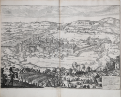
PLAN releué de la Ville et Citadelle de CAZAL auec le Paissage dalentour et lordre du Camp fait deuant jcelle par le Marquis de Spinola le 24 jour de May 1630 et defendue par M.r de Toiras...
A low-middle oblique view of the second siege of Casale Montferrato, besieged by the Spanish, commanded by Ambrogio Spinola, 1st Marquis of the Balbases (1569-25 September 1630) and defended by Jean Caylar d'Anduze de Saint-Bonnet, Marquis de Toiras (1585-1636), from 24 May to 18 October, when the town was relieved by a supporting French army under Henri II, duc de Montmorency (1595-30 October 1632). War of the Mantuan Succession (1628-31). Oriented with south to top.
A very rare view of the siege of Casale Monferrato, ascribed to the French engraver and publisher Melchior Tavernier.
Etching with engraving printed on contemporary laid paper, trimmed to the paltemark or with thin margins, very good condition.
https://militarymaps.rct.uk/thirty-years-war-1618-1648/siege-of-casale-monferrato-1630-plan-releue-de-la-ville
Melchior TAVERNIER (1564 ca. - 1644)
|
He was a member of a large family involved in the publishing trade in Paris in the early years of the seventeenth century .He is probably best known for his publication of a map of the Post Roads of France which was copied many times until the end of the century.He also issued an atlas under the same title as J. Le Clerc’s Theatre Geographique,using many of Le Clerc’s maps,but incorporating others from the maps noted below ,he pubblished works for other cartographers,including N.Sanson ,N.Tassin,and P.Bertius.He is not to be confused with his nephew of the same name (1594-1665),who also engraved maps for Nicolas Sanson.
1632 Carte Geographique des Postes qui traversent la France
1658 re-issued by N.Sanson
1634 Theatre Geographique du Royaume de France
1640-42 Description de la Carte Generale de tout le Monde
|